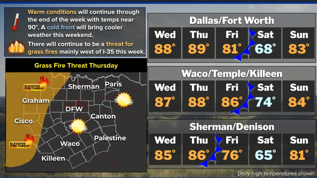
Very warm conditions will prevail through Thursday, followed by a cold front on Friday that will bring temperatures down through Saturday, with no precipitation forecasted. A rapid warm-up is expected Sunday through Tuesday of next week. These are the key weather stories for the next 7 days.
Good morning, and welcome to Wednesday. The forecast for North Texas over the next 7 days is relatively benign, with the exception of a notable cold front that will briefly cool the region during the second half of Friday through Sunday morning.
Currently, we are experiencing a mostly clear sky, but an area of low clouds is moving in from the Gulf, which may affect parts of North Texas through 10:00 a.m. Temperatures are mild for this time of year, with readings in the low 60s. Any clouds that move through this morning will dissipate by late morning, allowing for plenty of sunshine and warm temperatures in the upper 80s. It will be a breezy day with south winds gusting up to 20 mph.
Tonight, low clouds will attempt to move into the area from the south, with temperatures only falling to the mid-60s. South winds will pick up on Thursday, gusting up to 30 mph, allowing temperatures to warm up close to 90 degrees. The record high for Thursday is 91 degrees.
Low clouds may move in on Friday morning, with temperatures falling to the mid-60s. Brief sunshine will warm temperatures close to 80 degrees by lunchtime, but a strong cold front will bring a cloud bank, strong winds with gusts up to 35 mph from the north, and falling temperatures by evening. Your car thermometer will likely read 60 degrees when you drive home from work on Friday, so be sure to grab your jacket.
As for rainfall along or behind the front, there is a slight chance of a few showers behind the front late Friday into Saturday morning, but most areas will remain dry. Temperatures will fall to the upper 40s to low 50s on Saturday morning, with wind chills in the 40s.
Clouds will slowly break up by Saturday afternoon, with highs in the mid to upper 60s, which is slightly below average for this time of year. We will return to the 50s on Sunday morning, but south winds will return, rapidly warming temperatures to the low 80s.
The cooler air will not last long, as our warming trend will continue for Monday and Tuesday, with afternoon highs in the mid-80s and morning lows in the low 60s.
Unfortunately, we need rainfall, but none is forecasted for the next 7 days. However, the good news is that this dry weather pattern may change as we enter April. Please note that April and May are our top two months for severe weather in North Texas, so stay tuned for updates.
Have a great Wednesday and enjoy the weather when you can, it's the only weather you've got!
7-Day Headlines:- DFW Airport reached 84 yesterday.
- Wind picking up.
- Warming temperatures Wednesday and Tuesday.
- Grass fire danger.
- Friday lunchtime windy cold front. A few showers.
- A cool Saturday, warming Sunday- Tuesday.
- *Yest Rain: 000”; Yest High: 84; Low: 61
- *Today’s Averages: High: 71; Low: 50
- *Record high: 97 (1899); Record low 26 (1955)
- *March rain: 2.91”; Surplus: 0.33”
- *2026 Rain: 5.15”; Snow: 2.4” Deficit: <2.72”>
- *Sunrise: 7:24am; Sunset: 7:44pm
- Wednesday: Morning clouds, afternoon sun. Breezy. High: Mid to upper 80s. Wind: South 10-20 mph.
- Wednesday night: Partly cloudy, breezy and mild. Low: Mid to upper 60s. Wind: South 10-20 mph.
- Thursday: Partly cloudy and warm. High: Near 90. Record is 91 degrees. Wind: SE 15-25, G30 mph.
- Friday: Increasing clouds. Noonish cold front. Windy and cooler, with a few showers through the day. High: Near 80 early, falling into the 50s by mid evening.
- Saturday: Mostly to partly cloudy, breezy and cool. High: Mid to upper 60s.
- Sunday: Sunny and perfect! High: Near 80.
- Monday and Tuesday: Sunny, breezy and warm. High: Mid 80s.
LISTEN on the Audacy App
Tell your Smart Speaker to "PLAY 1080 KRLD"
Sign Up to receive our KRLD Insider Newsletter for more news
Follow us on Facebook | Twitter | Instagram | YouTube
Cold front arrives Friday
Cold front arrives Friday