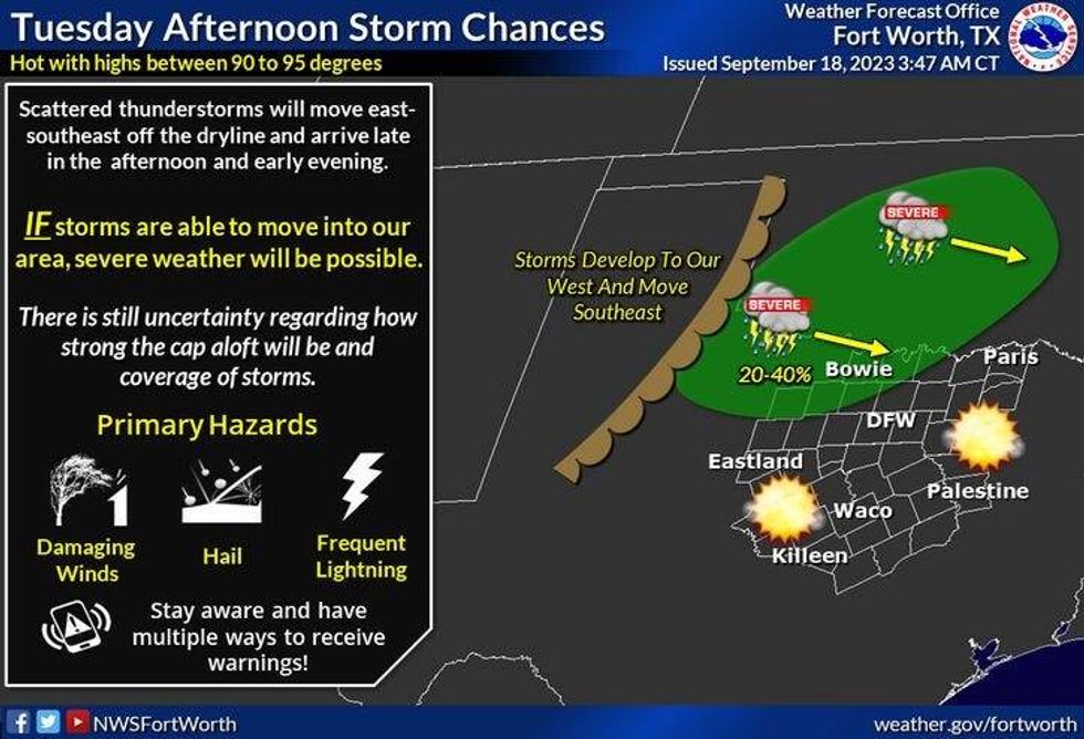
Welcome to the last week of Summer! Unfortunately it's going to feel like Summer this week with above average temperatures, and a few lucky ones will see some rain, especially late Tuesday into early Wednesday and then again late Saturday. A few storms late tomorrow evening may become severe, especially north of Highway 380.
In the meantime, enjoy this comfortable morning! Just about everybody has fallen well down into the sixties at this hour. We still have very dry air in place, so even though we'll reach the low 90s today, it'll feel a few degrees cooler than that.
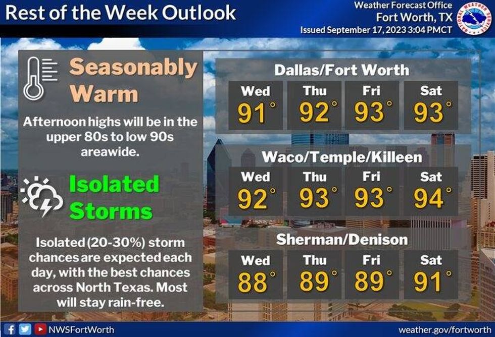
Southerly winds return overnight tonight and will continue through the rest of the week. It'll be a breezy week with increasing humidity. Afternoon highs tomorrow through Saturday will reach the low 90s.
 National Weather Service - Fort Worth
We're going to keep an eye on the northwestern sky late Tuesday into early Wednesday morning. Scattered strong to severe storms will break out across southern Oklahoma and northwest Texas tomorrow evening. Some of these may hold together and affect the northern half of north Texas into early Wednesday morning. Hail and damaging wind will be the threats. Coverage will be around 30% in DFW ...40% to 50% closer to the Red River Valley.
A few storms will redevelop in east Texas on Wednesday, but they won't affect the Dallas-Fort Worth area.
 National Weather Service - Fort Worth
There's a very slight chance for a late day storm Thursday and Friday, but a bit better chance will arrive late Saturday as a weak cold front moves into the area. Afternoon highs will cool into the mid 80s on Sunday under a clear sky.
By the way, Fall officially arrives at 1:50 a.m. early Saturday morning.
*Yest Rain: 0.00"; Yest High: 91; Low: 69
*Today's Averages: High: 88; Low: 68
*Record high: 100 (1975): Record low: 47 (1981)
*September Rain: 0.31"; Deficit: 1.35"
*2023 Rain: 15.14"; Deficit: 11.07"
*Sunrise: 7:14am; Sunset: 7:30pm

Today: *Air Quality Alert* Mostly sunny and warm. High: Low 90s. Wind: South 5 mph.
Tonight: Clear and mild. Low: 68-72. Wind: South 10 mph.
Tuesday: Partly cloudy, breezy and warm. Scattered late evening storms.Isolated severe towards midnight. Threats: Hail and damaging wind. High: Low 90s. Wind: South 10-20, G25 mph.
Wednesday: Morning showers and storms, then partly cloudy, and warm. Slight chance of afternoon showers and storms, mainly east of DFW. High: Near 90.
Thursday and Friday: Partly cloudy, windy and warm. Slight chance of late day showers and storms. High: Low 90s.
Saturday: *First day of Fall* Partly cloudy, windy and warm. Slight chance of evening showers and storms. High: Low 90s.
Sunday: Sunny and a bit cooler. High: Mid 80s.
LISTEN on the Audacy App
Tell your Smart Speaker to "PLAY 1080 KRLD"
Sign Up to receive our KRLD Insider Newsletter for more news
Follow us on Facebook | Twitter | Instagram | YouTube