Good morning everyone, happy Monday! In case you haven't heard, we broke the record high yesterday when we reached 106 degrees. It marked the 36th triple-digit day of the year in North Texas and the 21st consecutive day at or above 100 degrees. Some relief is coming though.
This summer has been the hottest summer in quite some time. This morning, as of 7:00 a.m., DFW Airport has been above 80° for 15 straight days. This record will come to an end overnight tonight, as temperatures dip below 80° for the first time in over 2 weeks!
A cold front crossed the Red River Valley on Monday morning. This front will arrive in Dallas-Fort Worth late this morning through the early afternoon knocking temperatures down to near 100 degrees at DFW Airport. They will fall to the low to mid-90s north of the area and slightly above 100 to our south. This is where Heat Advisories and Excessive Heat Warnings will continue Monday. There is a very slight chance of scattered showers Monday afternoon south of North Texas. Unfortunately, I'm not expecting any rain in the metroplex.
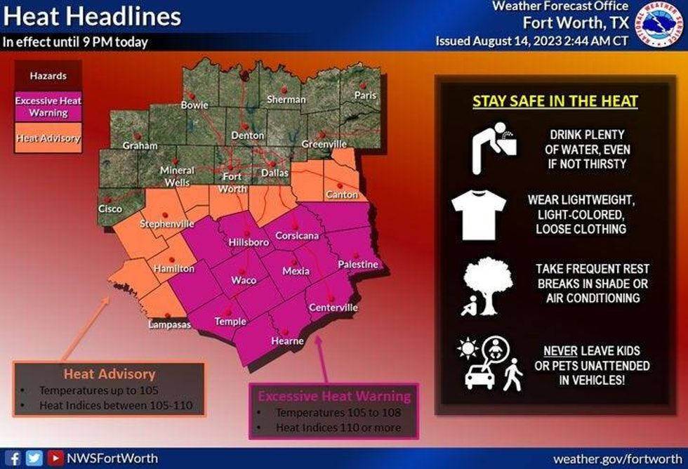 Heat Advisories and Excessive Heat Warnings in place Monday in parts of North Texas.National Weather Service
The cool-down will be noticeable starting Tuesday morning as temperatures fall into the upper 60s to low 70s across the area. Northerly winds will continue to usher in cooler air afternoon highs in the mid-90s.
There will be another relatively cool start for Wednesday morning with areas away from DFW dipping into the 60s, but afternoon highs will warm to near 100 degrees.
Unfortunately, the upper-level ridge builds right back over North Texas Thursday through Sunday as the intense heat rapidly returns. Afternoon highs will be 105 degrees or higher through the period, with Excessive Heat Warnings returning to the area.
Extended model data is hinting at slightly cooler temperatures returning the following week.
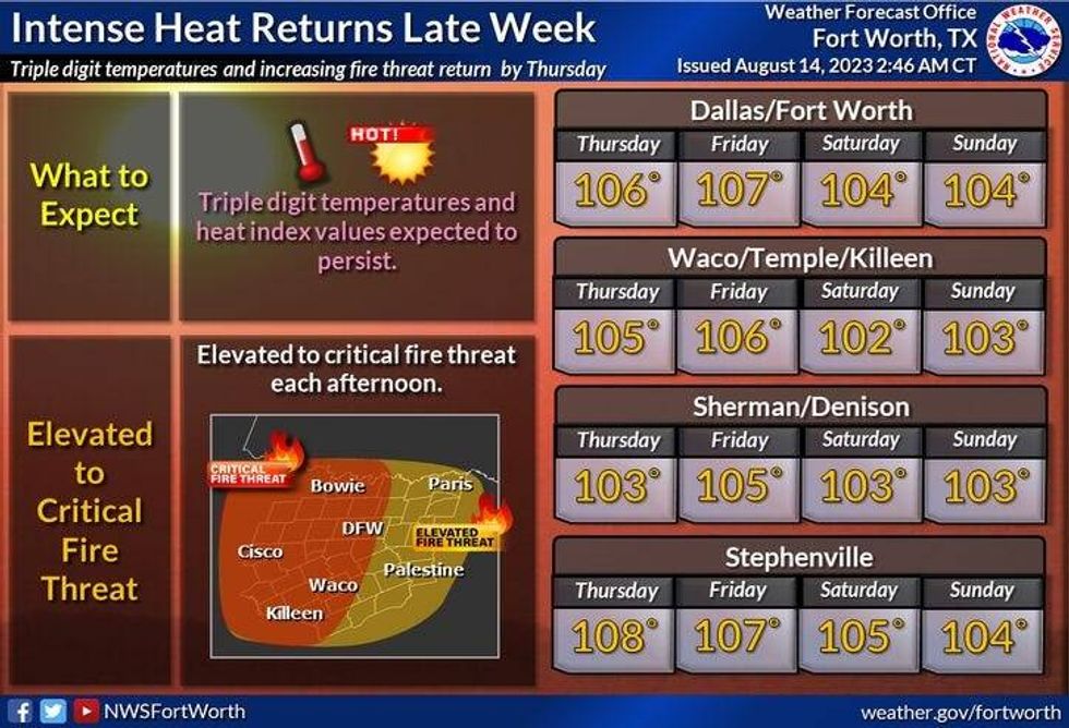 Extended North Texas forecastNational Weather Service
7-Day Headlines
* DFW reached 106 degrees Sunday, a new record.
* 36 triple-digit days in 2023, 21 in a row.
* Heat Warnings and Advisories south of DFW Monday.
* Elevated fire threat Monday.
* Cold front Monday brings a brief cooldown through Wednesday.
* Slight rain chance south of DFW.
* Triple digits return Thursday-Sunday.
*Sunday Rain: 0.00"; Sunday High: 106(Rec) Low: 84
*Monday's Averages: High: 97; Low: 76
*Record high: 106 (1911, 2012): Record low: 62 (1967)
*August Rain: Trace; Deficit:
*2023 Rain: 14.83"; Deficit:
*Sunrise: 6:51am; Sunset: 8:15pm
Monday: *Heat Advisories and Warnings south of DFW* Partly cloudy and cooler. Slight rain chance south of DFW. High grass fire danger. Highs: 93-102. Wind: NNE 10-20 mph.
Monday night: Clear and cooler. Lows: 67-73. Wind: NNE 10-20 mph.
Tuesday: Sunny, not as hot. High: Mid 90s. Wind: NNE 10-20 mph.
Wednesday: Sunny and a bit warmer. High: Upper 90s.
Thursday and Friday: Sunny, breezy and very hot. High: 107.
Weekend: More of the same. Sunny and very hot. High 106.
LISTEN on the Audacy App
Tell your Smart Speaker to "PLAY 1080 KRLD"
Sign Up to receive our KRLD Insider Newsletter for more news