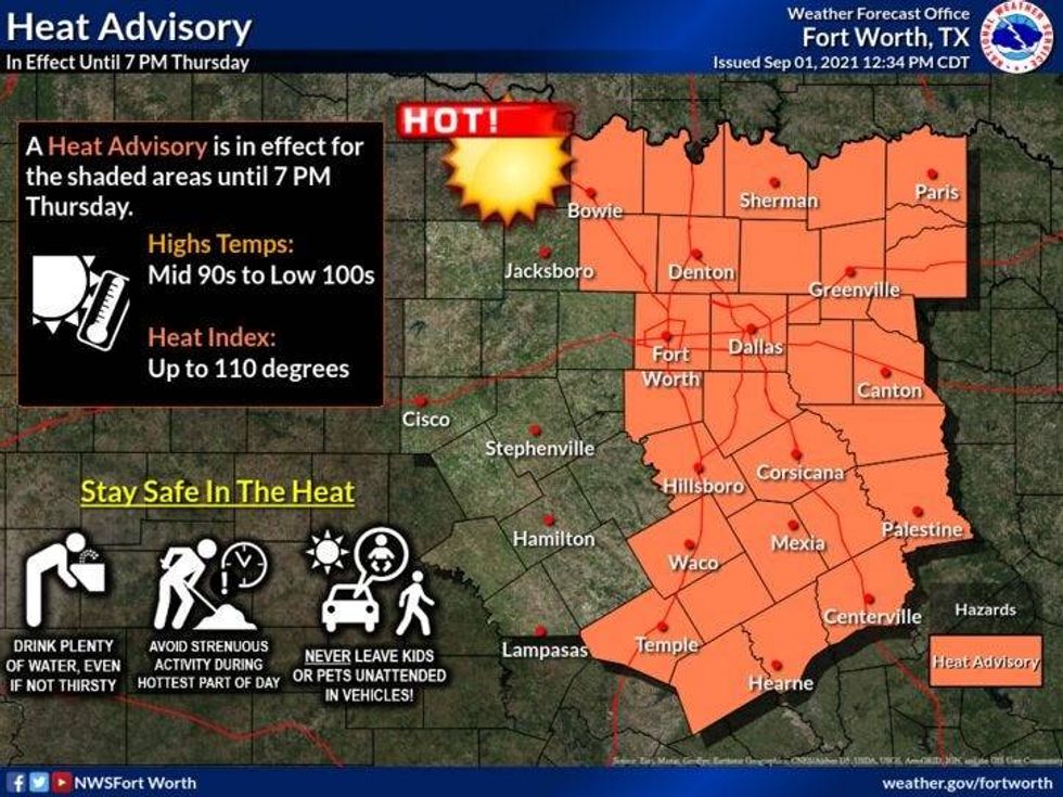
High pressure in the upper levels of the atmosphere will continue to dominate our weather through Saturday. Another Heat Advisory is in effect for all of north Texas today and possibly tomorrow.
 NWS
NWS
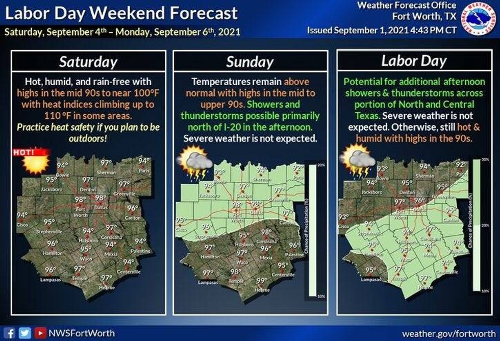
Yesterday we hit 99゚ at DFW... we'll hit that mark again today and possibly tomorrow. Hot weather continues through Sunday with daytime highs in the mid to upper 90s.
Things have changed in the forecast for Sunday and Labor Day. A cold front will sag into the area sometime Sunday producing scattered strong and isolated severe thunderstorms, with damaging wind being the primary threat. It's still to early to predict the timing of this front. Some data has it coming through Sunday afternoon other data has it coming through late Sunday into early Labor Day. Either way, I have to add storms to the forecast during this time frame. As of now, most of Labor Day looks quiet with the exception of some leftover morning showers, that is, if the front comes to a little later on Sunday.
 NWS
NWS
A few isolated late day showers and storms remain in the forecast Labor Day through Wednesday of next week. High temps with be in the mid 90s, with a ton of humidity.
Enjoy the heck out of your day today!
____________________________________________________
7-Day Headlines:
* 99 degrees yesterday at DFW.
* Heat Advisory today. Feeling like 105 degrees.
* Upper level high dominates into Sunday.
* Cold front brings rain late Sunday into early Labor Day.
* Remnants of Ida now moving out to sea in Cape Cod, MA.
__________________________________________________________
*Yest Rain: 0.00"; *Yest High: 99; Low: 79
*Today's Averages: High: 92; Low: 73
*Record high: 109 (2000); Record low: 50 (1915)
___________________________________________________________
*September rain: 0.00"; September deficit:
*Sunrise: 7:04am; Sunset: 7:51pm
Today: *Heat Advisory*..Partly cloudy and hot. An isolated late day shower or storm (south and east of DFW). High: Near 100. Heat index: 105+. Wind: SE 10-15 mph.
Tonight: Clear and muggy. Low: Mid to upper 70s. Wind: SE 5 mph.
Friday-Sunday: Partly cloudy and hot. High: Mid to upper 90s. Heat index: Near 105. Wind: SE 5-10 mph.
Sunday: Sunshine early, increasing clouds late. Decent chance of strong storms late Sunday into early Labor Day morning. Threat: Wind. Highs: Mid to upper 90s.
Labor Day: Morning showers and storms, afternoon sun. High: Low to mid 90s.
Tuesday and Wednesday: Partly cloudy, hot and humid. Isolated late day showers and storms. High: Low to mid 90s.
LISTEN on the Audacy App
Sign Up and Follow NewsRadio 1080 KRLD