One last day of 80° weather, a huge weather change late tonight with colder air and some rain arriving, staying chilly through all of next week, and more rain in the forecast by next Monday.
We're waking up to a partly cloudy sky and temperatures in the low to mid 60s. A mix of sun and clouds today with readings getting close to 80° again. Yesterday we hit 83° at DFW airport.
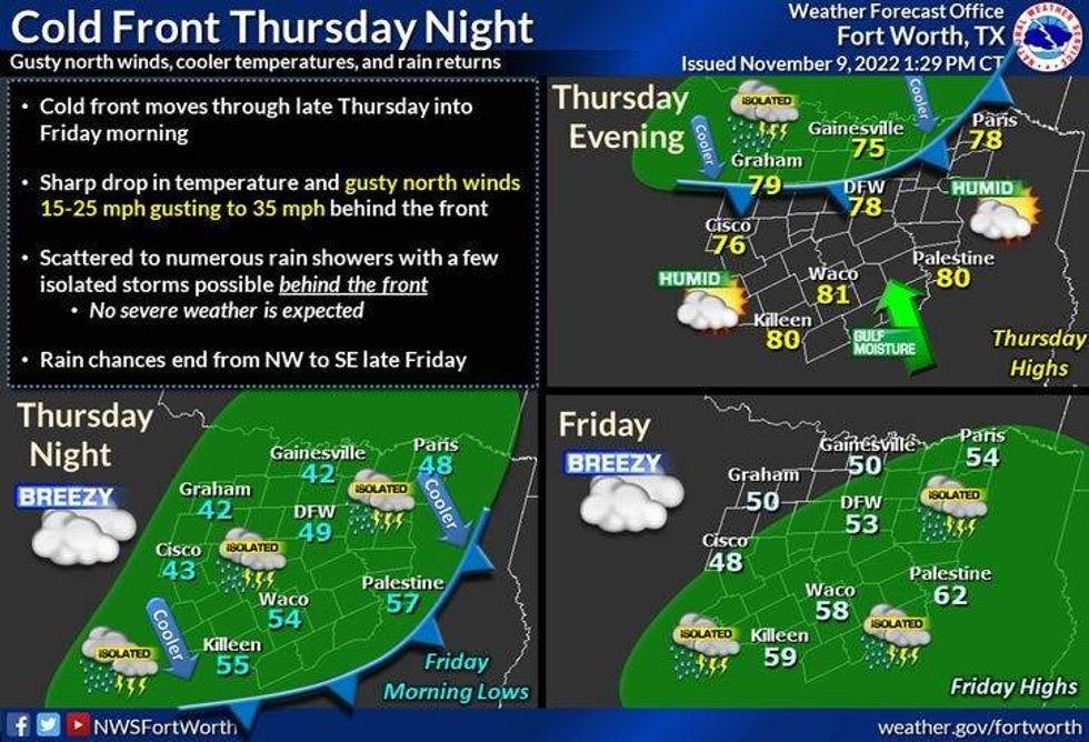
After midnight tonight, a very strong cold front will plow through the area bringing a chance of scattered showers and a rumble of thunder to all of North Texas. Nothing severe is expected.
 National Weather Service - Fort Worth
This front will continue to head towards the Texas Coast by Saturday morning. In its wake, an upper level disturbance will cross through central Texas during the day tomorrow giving us one more wave of scattered showers and storms from late morning into the early afternoon hours. The heaviest rain will be south and east of DFW.
The colder air behind the front will be the biggest story. This colder than average temperature regime will continue through the weekend and all of next week. Readings will be in the upper 60s at midnight tonight, upper 40s when you're driving into work tomorrow, and low 40s when you're heading home. Factor in the 35 mph wind gusts, wind chills will be in the 30s all day long.
 National Weather Service - Fort Worth
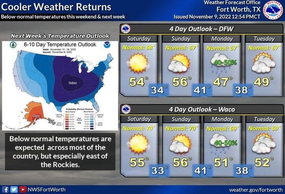
The weekend's looking pretty nice but please protect your plants, cover tender vegetation, and bring your pets indoors for Saturday and Sunday mornings. Low temperatures will range between 28 and 34 degrees, with a light freeze expected away from the DFW. Afternoon highs will reach 50° on Saturday, mid 50s on Sunday.
By Sunday night, clouds will increase rapidly out and ahead of our next weather maker. This system will bring a chilly rain to all of North Texas on Monday. Temperatures on Monday will start off in the upper 40s and then fall into the low 40s by evening. Nothing severe is expected.
We slowly clear up Tuesday and Wednesday, but it remains cold. 45 for a highTuesday, 49 on Wednesday, with morning lows well down into the 30s again.
*Yest Rain: 0.00"; High: 83; Low: 67
*Today's Averages: High: 69; Low: 48
*Record high: 86 (1934, 1949); Record low: 26 (1955, 1991)
*November rain: 3.04"; Surplus: 2.10"
*2022 Rain: 30.89"; 2022 deficit: 1.69"
*Sunrise: 6:54am; Sunset: 5:30pm
Today: Some morning clouds, afternoon sun. Breezy and warm. High: Near 80. Wind: South 10-20 mph.
Tonight: Increasing clouds, chance of showers and isolated NON SEVERE storms after midnight. Turning windy and MUCH colder. Low: Upper 60s, falling into the 40s by daybreak. Wind: North 15-25, G30 mph.
Friday/Veterans Day: Mostly cloudy, windy and cold. Chance of a chilly rain through early afternoon. High: Falling temperatures into the low 40s by early evening. Wind chills in the 30s. Wind: North 15-25m G35 mph.
Weekend: Sunny and cool. Highs: Low to mid 50s. Lows: 28-34.
Monday: Increasing clouds. Chance for chilly showers and isolated storms. High: Falling through the 40s.
Tuesday: Partly cloudy, continued chilly. High: Mid 40s.
Wednesday: Sunny, continued cold. High: Upper 40s. Low: 30s.
LISTEN on the Audacy App
Tell your Smart Speaker to "PLAY 1080 KRLD"
Sign Up and Follow NewsRadio 1080 KRLD