Good morning, everyone! Hope you had a great Monday. We're back to work this morning with dry roadways and no weather-related travel problems across North Texas.
Temperatures are starting the day mainly in the upper 70s to lower 80s, and we'll continue to see breezy conditions today and through the rest of the week.
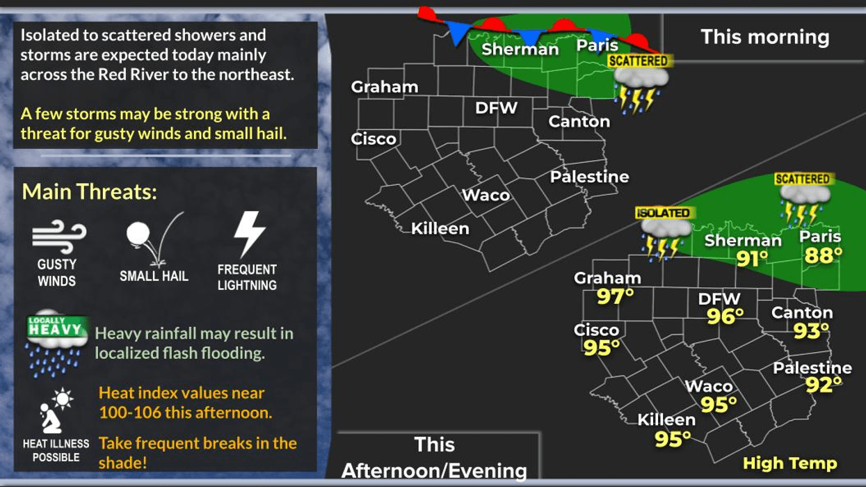
Today will be mainly dry and hot, but I'm watching a cluster of thunderstorms developing across western Kansas this morning. Those storms will dive southeast through the day and could survive long enough to reach areas near the Red River later this afternoon and evening.
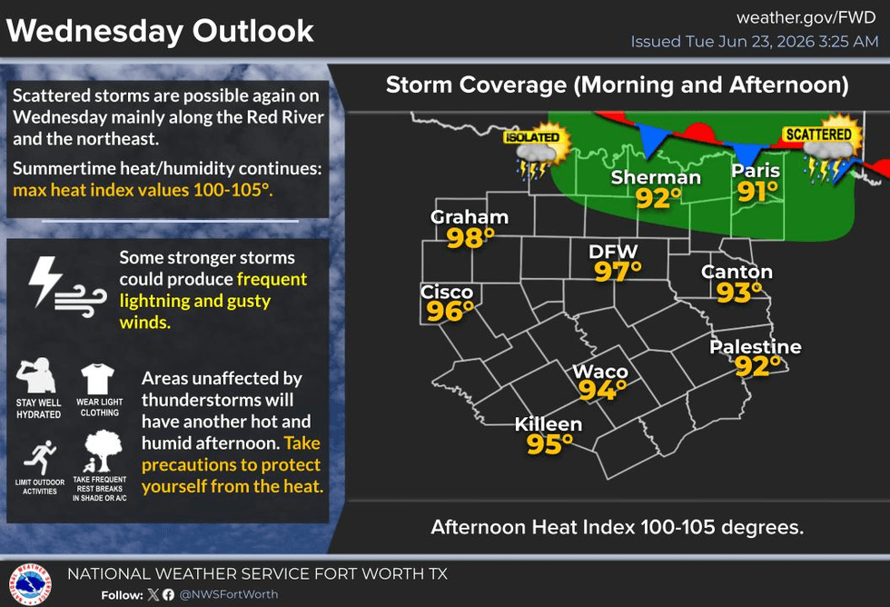
A second complex of storms is expected to develop across Kansas late this afternoon and evening. That system will also move southeast overnight and may reach portions of North Texas sometime during the early to mid-morning hours Wednesday. While widespread severe weather is not expected, a few storms could bring gusty winds, lightning, and brief heavy rainfall if they hold together.
After those storm chances move through, high pressure will strengthen in the upper levels of the atmosphere. That means a return to hot and mainly rain-free weather for the end of the week and into the weekend.
Forecast Highs
• Today: Mid to upper 90s
• Wednesday: Mid to upper 90s
• Thursday: Mid to upper 90s
• Friday through the Weekend: Near 100
When you factor in the humidity, it will feel hotter than the actual air temperature, with heat index values topping 100°. Heat advisories may become necessary this weekend, especially across western portions of Texas where temperatures will be even hotter and heat index values could exceed 105°.
Summer Heat Safety Tips
• Drink plenty of water and stay hydrated.
• Wear light-colored, loose-fitting clothing.
• Use sunscreen and wear a hat when outdoors.
• Make sure pets have access to shade and plenty of water.
• Check the back seat for children and pets every time you leave your vehicle. Interior temperatures can easily exceed 140°.
So, we have a small storm chance late this afternoon and another chance Wednesday morning into early afternoon. After that, the forecast turns hot and dry for several days.
Have a great Tuesday, and enjoy the weather when you can—it's the only weather you've got!
— Dan the Weatherman
7-Day Headlines:
- DFW Airport hit 97 degrees on Monday. Heat index reached 108 degrees
- Scattered late day storms today
- Scattered Wednesday morning storms
- Upper level high build in late week through the weekend
- Mid to upper 90s through Friday. Heat indices 105+
- Approaching 100 degrees this weekend. Heat indices near 110
- Mosquitoes and humidity dominate
- Download our AUDACY app. Listen to KRLD at home
Almanac:
- Yest Rain: 0.00”; Yest High: 97; Low: 72
- Today’s Averages: High: 93; Low: 74
- Record high: 104 (1980); Record low 63 (1903)
- June rain: 8.07”; Surplus: 5.28”
- 2026 Rain: 21.25”; Snow: 2.4”; Surplus: 1.87”
- Sunrise: 6:21am; Sunset: 8:40pm
Forecast:
Tuesday: Partly cloudy, hot, breezy and humid. Scattered late day showers and storms. High: Mid to upper 90. Heat index 105+. Wind: SE 10-20 mph.
Tuesday night: Partly cloudy and humid. Low: Upper 70s. Wind: South 10-20 mph.
Wednesday: Decaying late morning showers and storms, afternoon heat and humidity. High: Mid to upper 90s. Heat index: 105+. Wind: South 10-20 mph.
Thursday and Friday: Partly cloudy, hot, humid and windy. High: Mid to upper 90s. Heat index: 105+. Possible Heat Advisories.
Weekend: Mostly sunny, windy, hot and humid. Highs: Upper 90s. Heat index: 108+ Possible Heat Advisories!
Monday: Mostly sunny, hot and humid. High: Near 100. Heat index 108+. Possible Heat Advisories.
LISTEN on the Audacy App
Tell your Smart Speaker to "PLAY 1080 KRLD"
Sign Up to receive our KRLD Insider Newsletter for more news
Follow us on Facebook | Twitter | Instagram | YouTube