


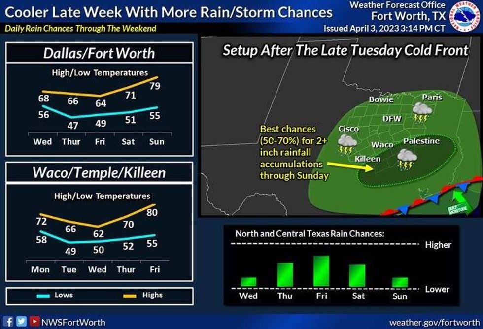
Here are your weather stories over the next seven days… A chance for isolated severe storms late this evening through early tomorrow morning, much cooler Wednesday through Friday, a chance of rain late Thursday through Saturday morning, with the heaviest south and east of DFW, and a nice Easter Sunday ahead with warming temperatures.
You won't need your jacket until this time tomorrow morning, as temperatures are well above average for this time of the year. This morning, temperatures are in the low 70s!
The sun will show its face today with high temperatures in the mid 80s! South winds will gust to 30 mph.
This evening, I'll be watching the progression of the dryline that'll be surging in from West Texas. This may spark 1 or 2 isolated supercells across the western half of North Texas. It depends on how strong the cap is.
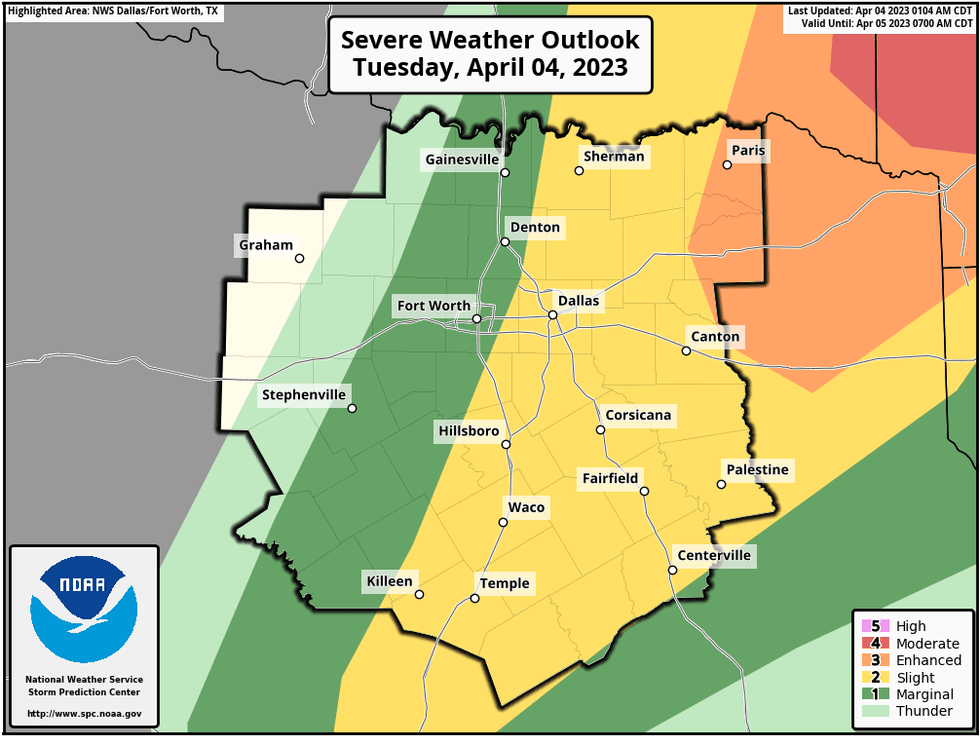
By late tonight, a strong cold front will plow through the area creating a line of showers and storms. As of now, it looks like this line of storms will form along and east of a Sherman to Mid Cities to Hillsboro line and then intensify as it races into the Arklatex. There is a level 2 out of 5 in place for severe storms across much of north Texas this evening through early tomorrow morning.
 National Weather Service - Fort Worth
You'll wake up tomorrow morning to temperatures in the mid 50s with a north wind gusting to 30 mph. This is when you'll need your jacket! Clouds will move out by afternoon with high temperatures only in the mid 60s.
Clouds will increase Thursday and there is a chance of showers, especially south and east of us late Thursday through Saturday morning. We may squeeze a quarter of an inch of rain out of this next system, but areas across southeast Texas will see upwards of 4 inches of rain. It will remain cool through the period with high temperatures in the low to mid 60s. The average high this time of the year is 74 degrees.
Clouds should move out by Saturday afternoon with high temperatures near 70゚. Easter Sunday looks fantastic with highs near 80゚. Monday will bring a partly cloudy sky with temperatures in the lower 80s.
Have an awesome day today and please enjoy the weather when you can, it's the only weather you've got!
7-Day Headlines:
* DFW reached 94 degrees yesterday. One away from the record.
* Very warm and windy today.
* Isolated severe storms late tonight, east of I-35E.
* THREATS: Hail, wind, an isolated tornado.
* Much cooler Wednesday - Friday.
* Possible rain Late Thursday - Saturday, heaviest south of us.
* Easter looks Fantastic!
*Yest Rain: 0.00"; Yest High: 94 Low: 64
*Today's Averages: High: 74; Low: 52
*Record high: 94 (1940); Record low: 31 (1920)
 National Weather Service - Fort Worth
*April Rain: 0.60"; Surplus: 0.30"
*2023 Rain: 8.71"; Deficit:
*Sunrise: 712am; Sunset: 7:50pm
Looking Ahead:
Today: Morning clouds, afternoon sum. Warm, windy and humid. High: Mid 80s. Wind: South 15-25, G30 mph.
Tonight: Partly to mostly cloudy, turning cooler after midnight. Scattered strong and isolated severe storms, mainly east of I-35W. THREATS: Hail, wind, isolated tornadoes. Low: Mid 50s. Wind: NW 15-25, G30 mph.
Tomorrow: Morning clouds, afternoon sun. Windy and cooler. High: Mid 60s. Wind: NNW 15-25 mph.
Thursday: Increasing clouds and cool. Slight chance of showers by late evening. High: Mid 60s.
Friday: Cloudy and cool. Isolated showers, heaviest well to the south of DFW. High: Low 60s.
Saturday. Morning showers, then mostly cloudy and a tad warmer. High: Near 70.
Easter Sunday: Mostly sunny and warmer. High: Upper 70s.
Monday: Partly cloudy and warm. High: Low 80s.

LISTEN on the Audacy App
Tell your Smart Speaker to "PLAY 1080 KRLD"
Sign Up to receive our KRLD Insider Newsletter for more news


