


Sometimes it takes a flood to break a drought, however, the drought is not gone but we've seen some welcome relief over the past 3 days across North Texas. Anywhere between 5 to 10 inches of rain has fallen through this time frame and there's more to come.
The Flash Flood Watch that was due to expire at 7:00 a.m. this morning has now been extended through the afternoon. Another wave of rain to our SW will move across areas along and east of I-35W late this morning into the early afternoon hours, then we'll get a bit of a break until Friday night. That is if you see a little sunshine.
A few isolated showers and patchy drizzle will cruise across the area overnight tonight as we drop to near 70°.
We'll see some breaks in the clouds by Friday afternoon with highs and the Low 80s. By Friday night, a large area of rain will develop to our south and clash with a slow-moving cold front coming in from the Northwest Friday evening into Saturday morning.
 National Weather Service - Fort Worth
More widespread rain will plague North Texas. An additional half inch to 1 inch of rain as possible through noon on Saturday. This cold front will stall south of the Dallas-Fort Worth area on Saturday, therefore there'll be a wide range of temperatures. 50s to the north of the front and 70s to the south of the front. Right now I'm thinking it'll stall just south of I-20.
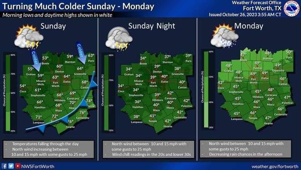
This front will sag well to the south of us by Sunday morning as north winds pick up and gust to 30 mph. There will be scattered showers around as temperatures tumble into the 40s by late afternoon.
Scattered showers will continue on Monday with low temperatures in the upper 30s to low 40s, afternoon highs will not get out of the mid-40s. It'll be a chilly - raw day.
 National Weather Service - Fort Worth
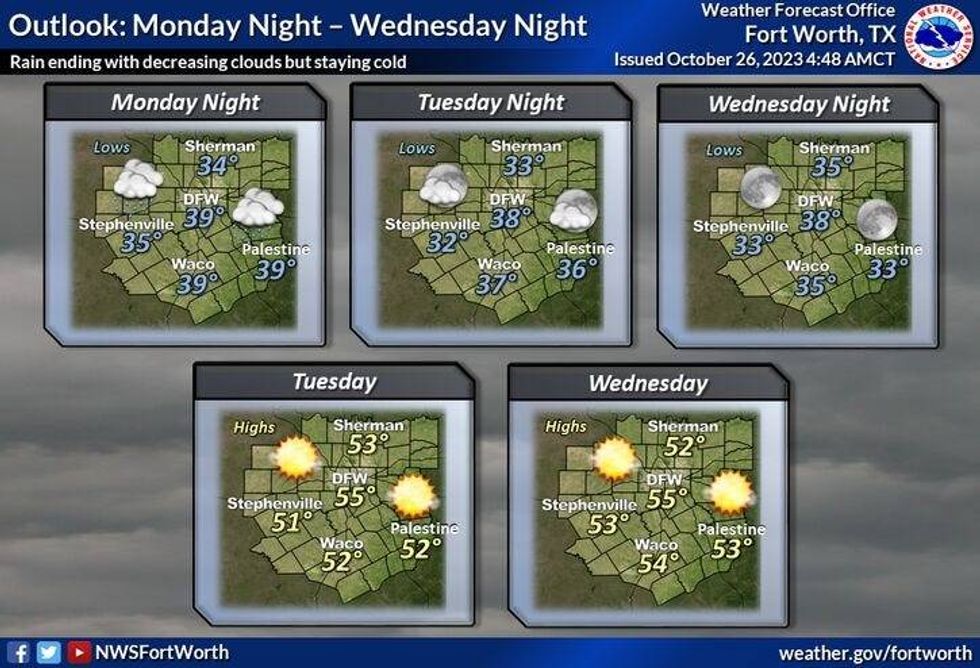
Slow clearing from north to south on Tuesday with afternoon highs struggling to hit 50°. Trick-or-treaters will experience temperatures in the upper 40s.
Plenty of sunshine will dominate on Wednesday, but it will remain very cool for this time of the year. Afternoon highs will be in the mid 50s.
*Yest Rain: 2.54"; Yest High: 80; Low: 68
*Today's Averages: High: 75; Low: 53
*Record high: 92 (1950) Record low: 33 (1898)
*October Rain: 2.77"; Surplus: 1.84"
*2023 Rain: 18.43"; Deficit: 9.77"
*Sunrise: 7:41am; Sunset: 6:43pm
Today: *Flood Watch until 7am* Cloudy and muggy. Scattered showers and isolated storms. High: Near 80. Wind: South 10-20, G25 mph.
Tonight: Cloudy, breezy and muggy. Isolated showers. Low: Low 70s. Wind: South 10-20 mph.
Friday: Mostly to partly cloudy and humid. Scattered showers and storms return by afternoon. High: Upper 70s. Wind: South 10-20 mph.
Saturday: Scattered showers/isolated storms. Turning colder north of I-20. Highs: Mid 50s north of I-20; Mid 70s, south of I-20.
Sunday: Cloudy, with a decent chance for rain. Cold front presses south of I-20 early. Turning windy and sharply colder. High: Falling into the 40s by afternoon. Wind chills in the 30s by evening.
Monday: Cloudy, windy and cold. Scattered showers pressing to our south by afternoon. High: Mid 40s.
Halloween: Decreasing clouds and unseasonably cool. High: 47-52.
Wednesday: Sunny and continued cool. Lows: 30s; Highs: 50s.
LISTEN on the Audacy App
Tell your Smart Speaker to "PLAY 1080 KRLD"
Sign Up to receive our KRLD Insider Newsletter for more news
Follow us on Facebook | Twitter | Instagram | YouTube


