Extreme heat warnings, dangerous heat, and maybe a little bit of rainfall by Friday evening — those are your weather stories as we migrate through our new work and school week.
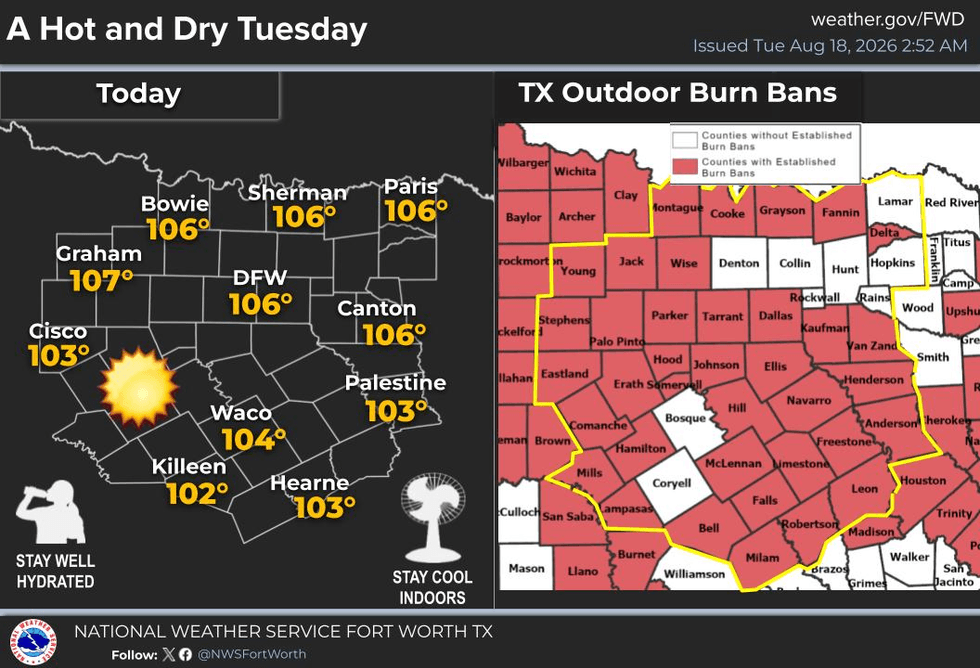
Believe it or not, we hit 106° yesterday at DFW Airport, and we're going to match that again today. We might even hit 107°. Extreme Heat Warnings are in place, and while the heat index won't be a major factor, the temperature itself will be.
So again, take it easy outdoors. Take frequent breaks, stay hydrated, check on your pets and make sure they have a cool place to stay. Periodically check in on the elderly and those with disabilities who may need some special attention during this brutal August weather pattern.
Afternoon highs today will again be close to 106°, perhaps a degree hotter tomorrow, around 105° on Wednesday, and about the same on Thursday and Friday.
But I'm tracking a weak cold front that's going to try to slide into the area Friday evening. It may touch off a few scattered showers and thunderstorms, especially along and south of I-380. Chances are slim, but at least it's in the forecast.
For Fort Worth, Saturday will be a degree or two cooler this weekend, with highs around 103°. Still, that's about 7 or 8 degrees above average for this time of year.
If you want to look at something on the bright side, temperatures are starting to trend downward as far as the averages go. That started Sunday, and we lose about a degree every three and a half days this time of year as we head toward fall and winter.
Fall officially begins on September 22 — so what's that, some quick math? 13 and 22... 35 days until the first day of fall!
And the State Fair of Texas is just around the corner as well. That'll cool you off!
Have a great day today, and enjoy the weather when you can. It's the only weather you've got!
7-Day Headlines:
- DFW Airport hit 106 degrees on Tuesday
- 24 triples this summer
- 33 days with no measurable rain at DFW
- Top 10 hottest August
- Heat Warnings are back again
- Slight rain chance late Friday
- Triple digits through next week
- Download our AUDACY app! Listen to KRLD LIVE at home or at work
Almanac:
- Yest Rain: 0.00”; Yest High: 106; Low: 81
- Today’s Averages: High: 96; Low: 76
- Record high: 11 (1909); Record low 65 (1992)
- August rain: Trace; Deficit: <1.03”>
- 2026 Rain: 22.61”; Snow: 2.4”; Deficit: <0.79”>
- Sunrise: 6:54am; Sunset: 8:09pm
Forecast:
Tuesday: **Extreme Heat Warning** Sunny and hot. Grass fire danger. High:106. Heat index:108. Wind: South 5-10 mph.
Tuesday night: Clear and warm. Low: Low 80s. Wind: South 10-15 mph.
Wednesday: **Possible Heat Warning** Sunny, breezy and hot. Grass fire danger. High: 107.
Thursday: **Possible Heat Warnings** Mostly sunny and hot. High: 106.
Friday: : **Possible Heat Warnings** Increasing clouds, continued hot. Evening “WEAK” cold font brings a chance of scattered showers and storms. High: 105.
Saturday: : *Heat Advisories likely** Showers and storms south of DFW. Mostly sunny and hot. High: 104.
Sunday and Monday: More of the same. Sunny and hot. High: 106.
LISTEN on the Audacy App
Tell your Smart Speaker to "PLAY 1080 KRLD"
Sign Up to receive our KRLD Insider Newsletter for more news
Follow us on Facebook | Twitter | Instagram | YouTube