
Morning fog, followed by afternoon sunshine, is expected to prevail on this beautiful Friday, with additional rain anticipated to move into the area late Sunday and persist until Monday noon. We are pleased to welcome a surplus of rainfall once again across North Texas.
Good morning, and we are delighted that it is finally Friday. Patchy fog is present across the area under a mostly cloudy sky. However, this fog will lift, and partly cloudy conditions will prevail this afternoon, with highs reaching the mid-70s, making for a beautiful day.
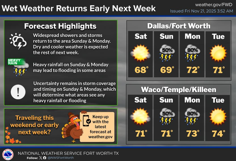
The storm system responsible for the recent rainfall will exit the state by early tomorrow morning, giving way to a picturesque Saturday. A weak cold front will move into the area on Friday night, causing temperatures to drop to the upper 40s to low 50s by Saturday morning. However, it will be sunny and 68 degrees by the afternoon, making for an enjoyable day.
Our next storm system will rapidly approach on Sunday, with increasing clouds throughout the day and rain moving in by late afternoon and evening. Some rain may be heavy at times, with isolated flooding possible overnight Sunday into Monday noon. The rain should be south and east of us by Monday afternoon, with afternoon highs reaching near 70 degrees.
On Tuesday, we can expect plenty of sunshine with highs in the low 70s, making for another beautiful day.
A strong cold front will move through North Texas before noon on Wednesday, causing temperatures to tumble through the 50s during the day and down into the mid-to-upper 30s by Thanksgiving morning. It will be a nice and cool Thanksgiving Day, with afternoon highs reaching only the mid-50s.
Some areas may experience a freeze on Friday morning, with afternoon highs reaching the upper 50s, making for a nice and cool fall day. A slow warm-up is expected into the following weekend.
As a side note, some weather pages have been discussing an Arctic air invasion for Thanksgiving. However, as you have just read, it will be cooler but not Arctic cold. It is essential to follow a reliable source for weather within a 7-day time frame, as anything beyond that is unreliable.
Have a terrific day today, an awesome weekend, and enjoy the weather when you can, it's the only weather you've got!
7-Day Headlines:
* DFW Airport reached 76 yesterday. Record rainfall: 3.95”
* Morning fog, afternoon sunshine.
* Friday evening weak/dry cold front.
* A perfect Saturday!
* More HEAVY rain Sunday evening into Monday morning.
* Turning colder Wednesday. 50s for Thanksgiving.
*November Rain: 3.98"; Surplus: +2.18”
*2025 Rain: 36.89”"; Surplus: +3.45”
*Sunrise: 7:05am; Sunset: 5:23pm
Friday: Morning fog, afternoon sun. High: Mid to upper 70s. Wind: WSW 5-10 mph.
Friday night: Clear and cooler. Low: 45-50. Wind: North 5-10 mph.
Saturday: Sunny and pleasant. High: Upper 60s.
Sunday: Increasing clouds and mild. Rain moving in by dinner time. High: Near 70.
Monday: Morning clouds and rain, then decreasing clouds and mild. High: Near 70.
Tuesday: Sunny and beautiful. High: Low 70s.
Wednesday: Mostly sunny, windy and MUCH cooler. High: Near 60.
Thanksgiving: Sunny and cool. Low: Mid to upper 30s; High: Mid 50s.
LISTEN on the Audacy App
Tell your Smart Speaker to "PLAY 1080 KRLD"
Sign Up to receive our KRLD Insider Newsletter for more news
Follow us on Facebook | Twitter | Instagram | YouTube