Forecast Discussion:
Following a picturesque weekend, the prevailing weather pattern is expected to persist until the end of this week and into the upcoming weekend. At that point, showers and storms, some of which may be severe, are anticipated to return to North Texas. As we enter April, be aware of the potential for changing weather conditions.
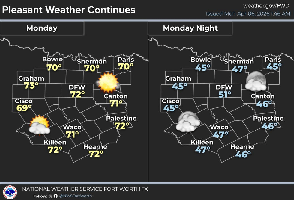
Good morning. I hope everyone had a pleasant Easter weekend. As we return to our regular work and school routines, wear a jacket when stepping outside this morning, as temperatures have dropped into the 40s across much of North Texas. The wind has subsided, and today is expected to be a beautiful day with ample sunshine. Afternoon highs are predicted to reach the low 70s.
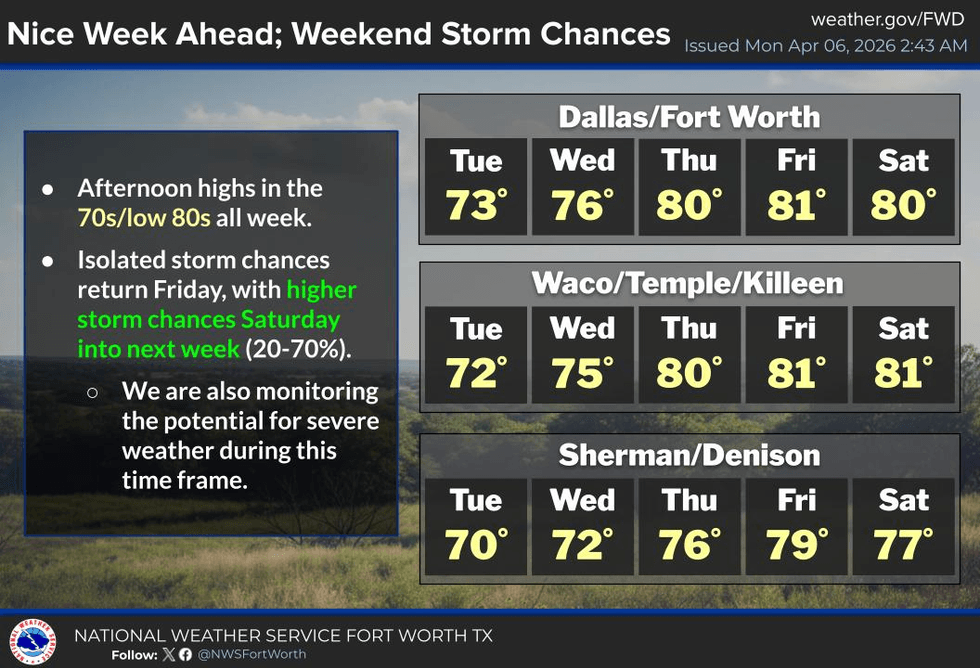
A surface high-pressure system will continue to nose into North Texas on Tuesday and Wednesday, maintaining cool mornings and mild to pleasant afternoons. Overnight lows will dip into the 50s, while afternoon highs will reach the low to mid-70s, which is near average for this time of year.
South winds will gradually return during this period as well. As we approach Thursday and Friday, temperatures are expected to rise to near 80 degrees, with morning lows in the low 60s. South winds will pick up, bringing Gulf moisture northward.
This weekend and into early next week, upper-level disturbances will move in from the southwest, triggering the dry line in West Texas. Severe storms will develop in these areas and move eastward during the late evening and early morning hours. The extent to which these storms will reach our area is still uncertain and will depend on the strength of the cap or lid on the atmosphere during this time frame. If any storms do reach our area, they are expected to be severe. Afternoon highs will reach near 80 degrees.
This pattern is anticipated to continue intermittently throughout the following week. I will continue to analyze the data as it becomes available this week and as we approach the weekend. By Friday, I hope to have a better understanding of what we can expect during the upcoming weekend. Please stay tuned for further updates.
Have a great day today, and be sure to enjoy the weather when you can, it's the only weather you've got.
7-Day Headlines:
- DFW Airport reached 70 on Sunday. 2.03” on Saturday!!
- Perfect weather all week!
- Seasonable temperatures.
- Gulf moisture slowly returns into the weekend.
- Storm chances increase late Saturday - Tuesday.
- Some storms MAY become severe.
Almanac:
- Yest Rain: 0.00”; Yest High: 70; Low: 47
- Today’s Averages: High: 74; Low: 53
- Record high: 95 (1960); Record low 35 (1994)
- April rain: 2.59”; Surplus: 2.10”
- 2026 Rain: 7.75”; Snow: 2.4” Deficit: <1.33”>
- Sunrise: 7:08am; Sunset: 7:53pm
7-Day Forecast:
- Monday: A cool start; A mild finish. Ample sunshine. High: Low 70s. Wind: Variable 5-10 mph.
- Monday night: Partly cloudy and cool again. Low: Mid to upper 40s. Wind: ESE 5-10 mph.
- Tuesday: Partly cloudy and perfect! High: Mid 70s. Wind: ESE 5-10 mph.
- Wednesday: Partly cloudy, continued nice! High: Mid 70s.
- Thursday and Friday: Partly cloudy and a tad warmer. High: Near 80.
- Saturday and Sunday: Partly cloudy and breezy. Scattered showers and storms return. High: Near 80.