Good morning everyone, and welcome to Tuesday!
An Excessive Heat Warning is in effect for much of North Texas this afternoon. High temperatures will climb to around 104°, but factoring in the humidity, it will feel more like 110° or higher. Heat advisories continue just south of the Dallas-Fort Worth Metroplex.
Expect sunny skies and no rain today. If you're working or spending time outdoors, stay hydrated, wear light-colored clothing, and take frequent breaks in the shade or air conditioning.
A subtle weather change arrives tomorrow as a backdoor cold front slips in from the northeast. It may provide just enough lift for a few isolated afternoon and early evening thunderstorms to develop. High pressure overhead will make it difficult for storms to grow, so many areas will stay dry, but we'll be watching closely. If a storm does develop, gusty wind and lightning will be the primary hazard, and any storms that form will quickly fade after sunset.
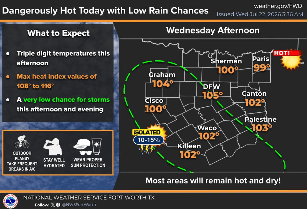
Temperatures will be slightly cooler Wednesday, with highs near 100°. Dry weather returns Thursday and Friday with highs around 101°. While that's a bit cooler, it's still above average for late July, and heat index values will remain above 105°, so additional heat advisories are likely.
Meanwhile, Tropical Storm Bertha formed overnight in the northern Gulf of Mexico. The storm is located about 100 miles south of Destin, Florida, moving northwest at 5 mph with maximum sustained winds of 50 mph. Bertha is expected to approach the New Orleans area by Thursday morning before tracking along the Louisiana coast and potentially making landfall near the Beaumont-Port Arthur area early Friday.
As the storm moves into Texas, strong high pressure over the state should cause Bertha to weaken rapidly. Even so, I can't rule out scattered showers and thunderstorms this weekend across the mid and upper Texas coast, East Texas, Central Texas, and perhaps even parts of the Dallas-Fort Worth area by Sunday. It all depends on how quickly the ridge weakens the storm.
In the meantime, expect temperatures to remain close to 100° through the end of the week and into the weekend.
Hope everyone has a great day, stay cool, and enjoy the weather when you can—it's the only weather you've got!
7-Day Headlines:
- DFW Airport hit 100 degrees on Monday
- 4th triple digit temperature this week
- Extreme Heat Warning/Heat Advisories today
- Heat index values 105-110 degrees
- Tropical Storm Bertha has developed
- Isolated storms on Wednesday
- Watching this weekend for scattered storms (Bertha)
- Download our AUDACY app! Listen to KRLD LIVE at home or at work
Almanac:
- Yest Rain: 0.00”; Yest High: 100; Low: 80
- Today’s Averages: High: 96; Low: 76
- Record high: 109 (2018); Record low 66 (1989)
- July rain: 1.36”; Deficit: <0.20”>
- 2026 Rain: 22.61”; Snow: 2.4”; Surplus: 0.76”
- Sunrise: 6:35am; Sunset: 8:34pm
Forecast:
Tuesday: **Extreme Heat Warning** **Heat Advisory** Sunny and hot. High: Near 105. Heat index 105-112. Wind: South 5 mph.
Tuesday night: Clear and warm. Low: Low 80s. Wind: SE 5 mph.
Wednesday: ** Heat Advisories likely** Partly cloudy and hot. Weak cold front. Isolated late-day showers and storms. Threats: Strong wind, lightning, brief heavy rain. High: Near 105. Heat index: Near 110. Wind South 5-10 mph.
Thursday: Sunny, a bit cooler. High: Mid to upper 90s. Heat index: Near 105.
Friday: ** Heat Advisories likely** Sunny and hot. High: Upper 90s. Heat index: Near 105.
Weekend: ** Heat Advisories likely** Sunny and hot. Isolated late day showers and storms. High: Near 102. Heat index 105+.
Monday: ** Heat Advisories likely** Sunny and hot. High: 102. Heat index: 105+.
LISTEN on the Audacy App
Tell your Smart Speaker to "PLAY 1080 KRLD"
Sign Up to receive our KRLD Insider Newsletter for more news
Follow us on Facebook | Twitter | Instagram | YouTube