
We're getting a taste of our 1st decent cold front across north Texas.
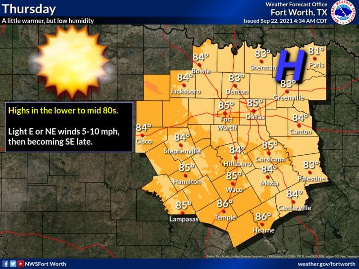
Humidity levels will stay low, ample sunshine, and below average temperatures are the rule through the end of the week! Afternoon highs today will be in the low 80s. Mid 80s tomorrow and Friday and warming into the upper 80s to near 90 through the weekend and into early next week. Morning lows will stay cool and comfortable. Tomorrow morning, low temperatures will fall into the low to mid 50s!

We could use some rain as well! September has been very dry. Analyzing some of the extended data, its showing signs of a pattern change by next Tuesday, we may see rain returning to north Texas.
Enjoy the 1st day of fall everybody!
*Yest Rain: 0.01”; *Yest High: 88; Low: 75
*Today’s Averages: High: 87; Low: 66
*Record high: 101 (2005); Record low: 45 (1983)
*September rain: 0.19”; September deficit: 1.81"
*2021 Rain: 27.03”; 2021 surplus +0.48”
*Sunrise: 7:16am; Sunset: 7:24pm
Today: Fall arrives at 2:21pm!! Sunny, breezy and cooler. High: Low 80s. Wind: North 10-20 mph.
Tonight: Clear and cool. Less wind. Low: Low to mid 50s. Wind: ENE 5-10 mph.
Tomorrow: Sunny and pleasant. High: Mid 80s. Wind: SW 5-10 mph.
Friday: Sunny and warmer. Opening day for The State Fair of Texas! High: Upper 80s.
Weekend: Sunny and warm, but pleasant mornings. High: Near 90.
Monday: More of the same. Mostly sunny and warm. Increasing humidity. High: near 90.
Tuesday: Scattered showers and storms may return! High: Mid to upper 80s.
Related

LISTEN on the Audacy App
Sign Up and Follow NewsRadio 1080 KRLD