
We are gradually approaching the commencement of fall, which will arrive next Monday. Over the next seven days, some of you may require an umbrella. This is indeed welcome news.
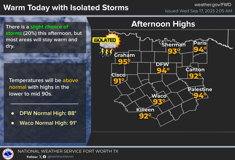
Happy Wednesday, ladies and gentlemen. We are awakening to a clear sky, a pleasant crescent moon in the eastern sky, and temperatures ranging from the low to mid-70s at this hour. Currently, there are no weather systems on 1080 weather radar. However, this may change later in the afternoon. I am predicting a 20% coverage of daytime and early evening showers and storms, primarily between 3:00 p.m. and 7:00 p.m., with most of you remaining dry.
High pressure in the upper levels of the atmosphere will briefly recede to the West on Thursday and Friday, allowing a couple of disturbances to enter the area. The first disturbance will arrive on Thursday in a weakened state. Nevertheless, there will be some showers and storms in our Northwestern counties early Thursday morning, although most of us will remain dry. Afternoon highs today and tomorrow will reach the low to mid-90s.
A second, stronger disturbance will move in for the Northwest on Thursday night and Friday. A large area of showers and storms will develop in Oklahoma on Thursday evening. In my opinion, these storms will hold together and arrive on Friday morning, just in time for your commute to work. As of now, it appears that these storms will weaken slightly as they arrive, but I cannot rule out some gusty wind, brief heavy rain in areas, and lightning. I will have a better understanding of the timing and strength of this system by this time tomorrow. Highs on Friday will reach 90 degrees.
The upper-level high will briefly return this weekend, allowing temperatures to warm back into the low 90s. Most of us will remain dry. By late Sunday night into Monday, another cold front and a stronger disturbance will arrive. Widespread shower and thunderstorm activity will break out on Sunday evening to the West and Northwest of us. These will move into the area during the day on Monday, dragging a weak cold front close to the area.
I am expecting more showers and storms to impact our weather on Monday as the entire system slowly moves to the South by Monday evening. There may be some heavy rain across the Hill Country and Central Texas, areas that truly need rain. Temperatures will cool into the 80s for most of next week, with morning lows in the 60s.
It is too early to determine if this upper-level low will become trapped to our South, maintaining clouds and the threat of showers and storms towards the middle to end of next week. Please stay tuned. Again, fall will arrive next Monday, and the weather pattern will reflect the seasonal change next week.
Have a great day today and enjoy the weather when you can, as it is the only weather you've got!
7-Day Headlines:
DFW hit 94 degrees on Monday.5 days until fall.Above average temperatures, for now.Isolated late-day showers and storms today and Thursday.Scattered storms Friday.Isolated late-day storms this weekend.Better rain chances next week along with cooler temperatures.
*Yest Rain: 0.00”; Yest High: 94 Low: 73
*Today’s Averages: High: 88; Low: 68
*Record high: 99 (1997); Record low: 44 (1903)
*September Rain: 0.69”; Deficit:
*2025 Rain: 27.74”; Surplus: 1.62”
*Sunrise: 7:13am; Sunset: 7:30pm
Wednesday: *Air Quality Alert* Partly cloudy and hot. An isolated late-day storm. High: Low to mid 90s. Wind: SW 5 mph.
Wednesday night: Mostly clear and mild. Low: Low to mid 70s. Wind: South 5 mph.
Thursday: Partly cloudy and hot. Isolated late-day storms. High: Low to mid 90s. Wind: SW 5-10 mph.
Friday: Mostly to partly cloudy and warm. Scattered showers and storms, especially in the morning. High: Upper 80s.
Weekend: Partly cloudy and warm. Isolated late-day showers and storms. Increasing rain chances LATE Sunday evening (west of DFW) High: Low 90s.
Monday: Mostly cloudy and warm. Scattered showers and storms. High: Near 90.
Tuesday: Mostly cloudy and cooler. Scattered showers and storms, especially south of DFW. High: Low to mid 80s.
LISTEN on the Audacy App
Tell your Smart Speaker to "PLAY 1080 KRLD"
Sign Up to receive our KRLD Insider Newsletter for more news
Follow us on Facebook | Twitter | Instagram | YouTube