
Happy Monday ladies and gentlemen! It was a very stormy Sunday night across Denton County. Flipped RVs and trucks as well as damage to a Walmart Distribution Center in Sanger late yesterday afternoon into the early evening hours. Now we're dealing with a flooding threat and Denton County early Monday morning. A complex of storms continues to slowly drift east-southeast this morning and packing areas along the north of Interstate 30. Make sure you check in on traffic and weather together on the 8s on NewsRadio 1080 KRLD AM. Joyce and I got you covered through the morning hours.
This morning's rain should taper off by lunchtime, but please stay weather aware in the flood-prone areas. A flood warning continues for Denton County until 8:15 this morning. Temperatures this afternoon will be warm and humid with highs in the low-to-mid 90s. Heat index values will approach 100°.
Tuesday is the calm before the storm. Partly cloudy, hot, and humid with highs in the mid-90s. Heat index value is close to 100° again.
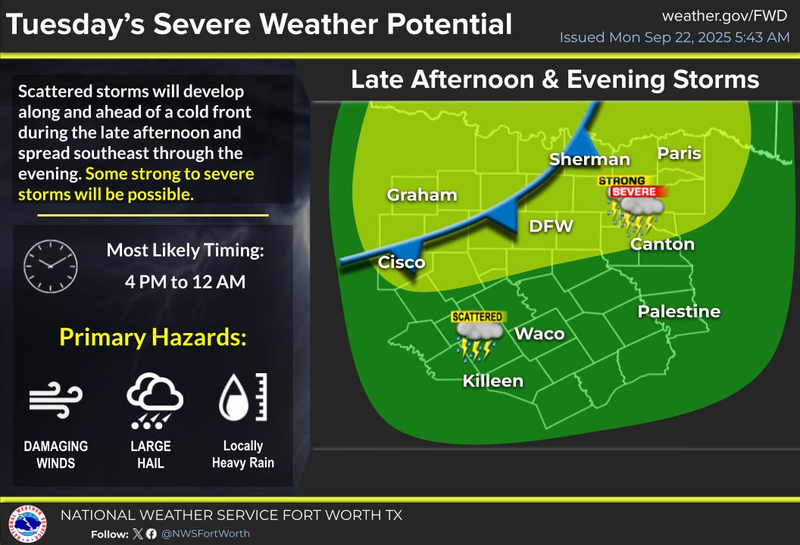
By late Tuesday into Wednesday, our first fall cold front arrives. Numerous showers and storms will develop along the front late Tuesday evening, and sag out through the early morning hours, pressing south of DFW by Wednesday afternoon. Heavy rain, frequent lightning, some hail, and damaging wind will be the threats. The tornado threat is very low, but you never can rule out a brief tornado during any severe weather event. Rainfall totals will range between 0.50" and 2.00" in areas.
Cooler/drier air will filter into the area Thursday and for the first day of the State Fair of Texas on Friday. Afternoon highs will reach the mid 80s, morning lows in the low to mid-60s! Time to start taking those morning walks again!
The weekend looks very nice, but it's heating up. Upper 80s to near 90 both Saturday and Sunday, with morning lows in the mid to upper 60s. Enjoy!
Please stay weather aware this morning, then again late Tuesday and Wednesday, and try to enjoy the weather when you can, it's the only weather you've got!
7-Day Headlines:
* DFW Airport reached 95 on Sunday.
* Pockets of heavy rain and flooding this morning.
* Fall arrives at 1:19pm today!
* Late Tuesday, early Wednesday cold front brings isolated severe storms.
* Cooler Thursday and Friday.
* A slow warm up this weekend. Near 90 degrees.
_________________________________________________________
*Yest Rain: 0.13"; Yest High: 95; Low: 74
*Today’s Averages: High: 87; Low: 66
*Record high: 100 (2005); Record low: 45 (1983)
__________________________________________________________
*September Rain: 0.82"; Deficit:
*2025 Rain: 27.87"; Surplus: 1.32
*Sunrise: 7:17am; Sunset: 7:23pm
__________________________________________________________
Monday: Morning storms, pockets of heavy rain, becoming partly cloudy, hot and humid. High: Low to mid 90s. Wind: South 10-20 mph.
Monday night: Partly cloudy and muggy. Low: Low to mid 70s. Wind: South 10-20 mph.
Tuesday: Partly cloudy and hot. High: Low to mid 90s.
Tuesday night: Scattered showers and isolated severe storms. Cold front. Low: 64-74.
Wednesday: Morning showers and storms. High: 78-83.
Thursday and Friday: Mostly sunny and seasonable. High: Mid 80s.
Weekend: Mostly sunny and warm. High: Near 90.