
Bid farewell to the 70s and 80s for the time being. Three cold fronts are expected to impact our weather over the next seven days, but unfortunately, precipitation is not forecasted until possibly early to mid-next week.
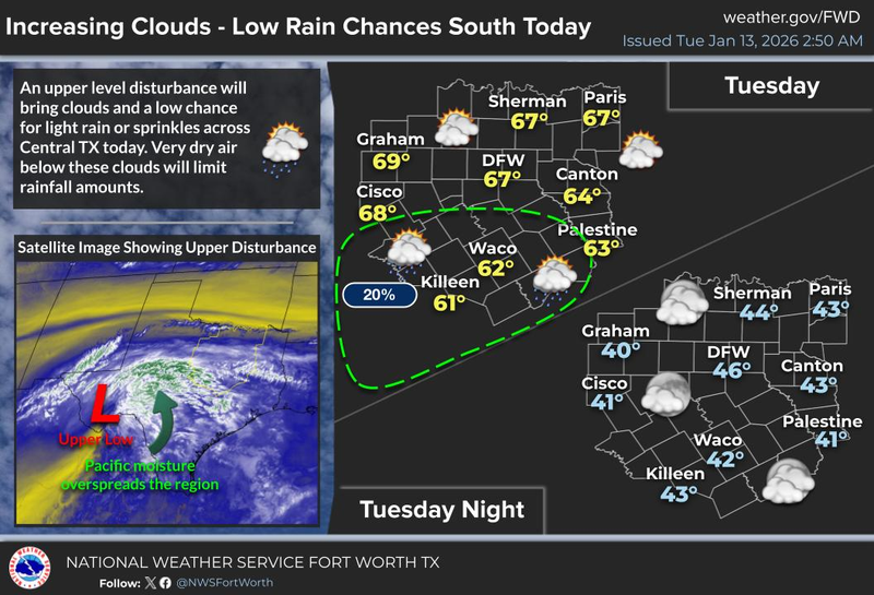
Good morning, and happy Tuesday. We are waking up to a partly to mostly cloudy sky this morning, with temperatures in the 30s and 40s. The clouds will be more pronounced the farther south you get away from North Texas, as a strong upper-level system moves through the Hill Country in Southeast Texas today. There will be some light rain showers impacting travel if you're heading south today, but unfortunately, no precipitation is expected for our area. A mix of sun and clouds is anticipated today, with afternoon highs reaching the mid-60s, similar to yesterday.
After midnight tonight, a windy cold front will arrive, but there's not a significant amount of cold air behind it. You will wake up tomorrow morning under a mostly cloudy sky, with temperatures in the mid to upper 40s. A north wind will gust up to 35 mph throughout the day on Wednesday, and highs will struggle to reach 60 degrees. The average high temperature for this time of year is 56 degrees.
Mostly sunny skies will prevail on Thursday as the wind relaxes. Morning lows will dip into the 30s, with afternoon highs returning to the low 60s. This is relatively close to average for this time of year.
Another weak cold front will arrive on Friday, reinforcing the cool, dry air that will already be in place. No precipitation is expected with this front. Friday highs will reach 60 degrees, with passing high clouds.
It will be slightly cooler on Saturday, with afternoon highs in the mid to upper 50s. There may be a light freeze in some areas on Sunday morning. Sunday will be sunny, breezy, and cool, with highs in the low 60s. Winds will pick up from the south at 20 mph.
The next weather change is expected to arrive early next week. Currently, it appears that clouds will increase on Monday, with highs returning to the low 60s. It's still too early to determine if we'll see any precipitation with our next system, which is expected to move in from the southwest late Monday and into Tuesday. Stay tuned for updates on this forecast.
I have a significant birthday approaching at the end of the month, and typically, it gets quite cold around that time. This is a pattern I've tracked for nearly 60 years. We'll see what happens this year.
That's all for now. I hope everyone has a terrific day today and enjoys the weather while they can. After all, it's the only weather you've got!
7-Day Headlines:
* DFW Airport reached 66 yesterday.
* Two DRY cold fronts this week.
* First front early Wednesday.
* Second front Friday.
* No rain for a while.
* Chilly mornings and cool afternoons though the weekend.
*Yest Rain: 0.00”; Yest High: 66; Low: 35
*Today’s Averages: High: 56; Low: 36
*Record high: 78 (1996); Record low: 7 (1912)
*January Rain: 0.01"; Deficit:
*2026 Rain: 0.01"; Deficit:
*Sunrise: 7:31am; Sunset: 5:44pm
__________________________________________________________
Tuesday: Mostly to partly cloudy, breezy and cool. A few showers in central Texas. High: Mid 60s. Wind: SW 10-20 mph.
Tuesday night: Partly cloudy and cool. Low: Mid to upper 40s. Wind: South 5-10 mph.
Wednesday: Early morning windy cold front. No rain. Partly cloudy to mostly sunny and cool. High: Near 60.48-53. Wind chills in the upper 40s. Wind NW 15-25, G35 mph.
Thursday: Mostly sunny and cool. Low humidity. High: Low 60s.
Friday: High clouds, remaining cool. Afternoon DRY cold front. High: Near 60.
Saturday: Sunny and cool. High: Mid to upper 50s.
Sunday: Sunny, breezy and cool. High: Low 60s.
Monday: Increasing clouds, remaining cool. Showers late? High: Low 60s.
LISTEN on the Audacy App
Tell your Smart Speaker to "PLAY 1080 KRLD"
Sign Up to receive our KRLD Insider Newsletter for more news
Follow us on Facebook | Twitter | Instagram | YouTube