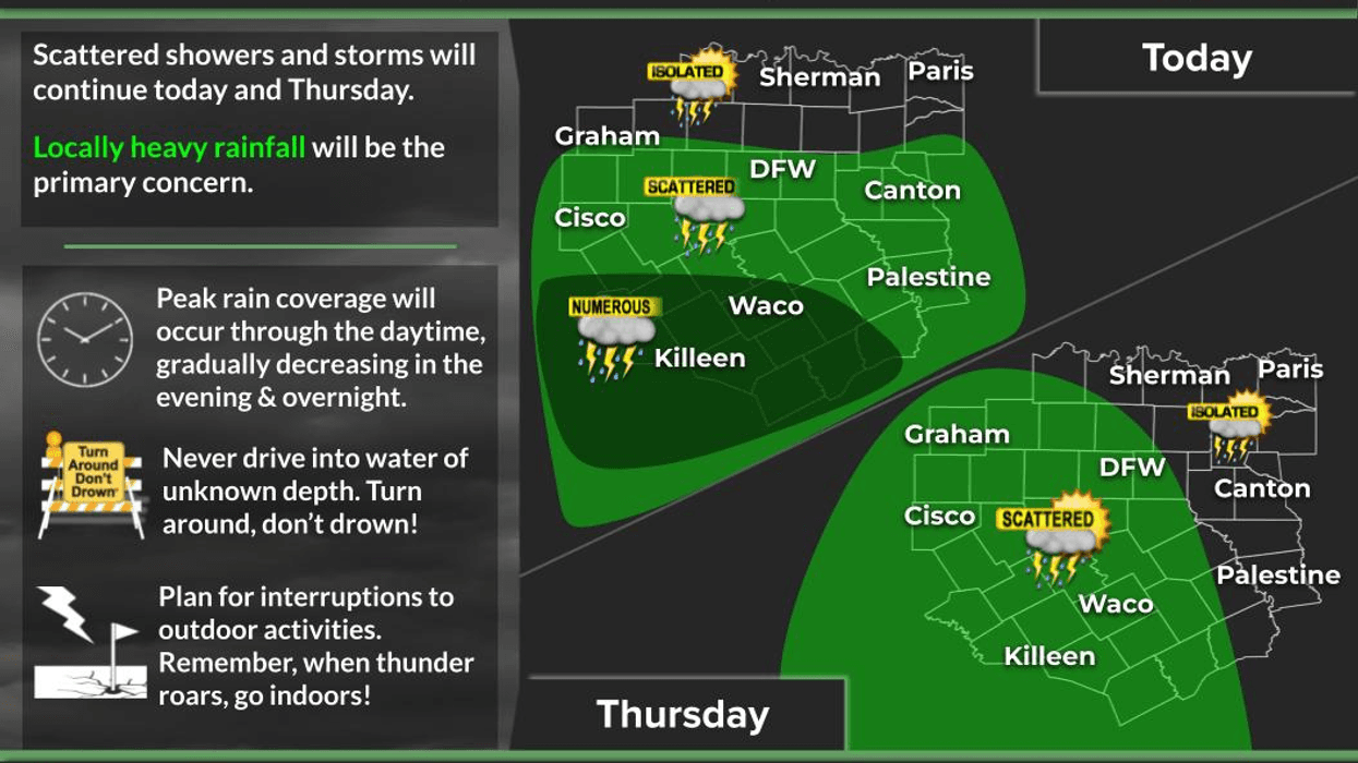

Scattered afternoon and evening showers and thunderstorms remain in the forecast through Friday. After that, we'll begin to warm up and dry out heading into the weekend.
Good morning! I hope everyone has a great Wednesday.
I've been tracking an upper-level low-pressure system across Southwest Texas that continues to produce flooding rains across parts of the Hill Country, the Mid Rio Grande, and the Upper Rio Grande Valley. This area of heavy rain and thunderstorms will slowly shift westward over the next 48 hours, lingering across West Texas through Thursday and Friday before finally exiting the state this weekend.
Flash Flood Watches remain in effect from Austin to San Antonio, south to Eagle Pass, then west along the Rio Grande into the Big Bend region, including the Davis and Guadalupe Mountains. The watch also extends generally along and south of the Colorado River and just south of the Midland-Odessa area. Additional flash flooding is expected over the next couple of days.
As of this morning, Doppler radar continues to show heavy rain west of I-35 and south of Highway 290, stretching from Austin to Fredericksburg and south toward Interstate 10. This includes Junction, Brady, Kerrville, Hondo, Pearsall, and Lakey. Some of these storms are nearly stationary, producing rainfall rates of 1 to 2 inches per hour.
Flood Warnings remain in effect for the Fredericksburg, Kerrville, and Uvalde areas, extending toward the Highland Lakes region. Overnight, many locations picked up an additional 3 to 6 inches of rain on top of what fell yesterday. Numerous Flash Flood Warnings and Flood Advisories also remain in effect around Junction, Hondo, and along the Nueces and Frio Rivers.
If you're camping, this is not a good time to be near rivers, creeks, or low-water crossings. If you're traveling or staying in an RV, make sure you have a safety plan and know where higher ground is located. Have multiple ways to receive weather warnings. A NOAA Weather Radio is an excellent tool because it can wake you up in the middle of the night if a warning is issued, giving you valuable time to seek higher ground.
Across North Texas, expect scattered afternoon and evening showers and thunderstorms today and Thursday, with only isolated activity on Friday. Rain chances are around 30% today, 40% Thursday, and 20% Friday. High temperatures will range from the upper 70s where clouds and rain persist to the lower 90s where sunshine breaks through.
This weekend finally looks dry, with highs returning to the lower and middle 90s. Heat index values will once again climb above 100 degrees.
I'm Meteorologist Dan Brounoff in the KRLD Weather Center. Enjoy the weather when you can—it's the only weather you've got!
7-Day Headlines:
- DFW Airport hit 92 degrees on Wednesday
- Scattered late day showers and storms through Friday
- Pockets of heavy rain
- HIghest coverage south of I-30 and west of I-35W
- Threats: Heavy rain, lightning, gusty wind
- Hot and dry this weekend
- Download our AUDACY app! Listen to KRLD LIVE at home or at work
Almanac:
- Yest Rain: 0.00”; Yest High: 92; Low: 75
- Today’s Averages: High: 96; Low: 76
- Record high: 107(1978); Record low 59 (1967)
- July rain: 1.29”; Surplus: 0.09”
- 2026 Rain: 22.54”; Snow: 2.4”; Surplus: 1.05”
- Sunrise: 6:31am; Sunset: 8:37pm
Forecast:
Wednesday: Partly cloudy, warm and humid. Scattered late day showers and storms. Highest coverage south of I-30. High: Low 90s. Wind: SE 5-10 mph.
Wednesday night: Partly to mostly cloudy and humid. Low: Low to mid 70s. Wind: SE 5-10 mph.
Thursday: Partly cloudy, warm and humid. Scattered showers and storms. High: Low 90s. Wind: South 10-20 mph.
Friday: Partly cloudy, warm and humid. Isolated late-day showers and storms. High: Near Low 90s
Weekend: Partly cloudy, hot and humid. Highs: Mid 90s.
Monday and Tuesday: Mostly sunny, hot and humid. High: Upper 90s.
LISTEN on the Audacy App
Tell your Smart Speaker to "PLAY 1080 KRLD"
Sign Up to receive our KRLD Insider Newsletter for more news
Follow us on Facebook | Twitter | Instagram | YouTube