
MULTIPLE INCHES OF RAIN HEADING INTO NORTH TEXAS!
Good morning, everyone! I hope you’ve had a great workweek so far!
We’re FINALLY going to see some much-needed rain around here — but sometimes too much rain in a short period of time can create a whole new problem: FLASH FLOODING.
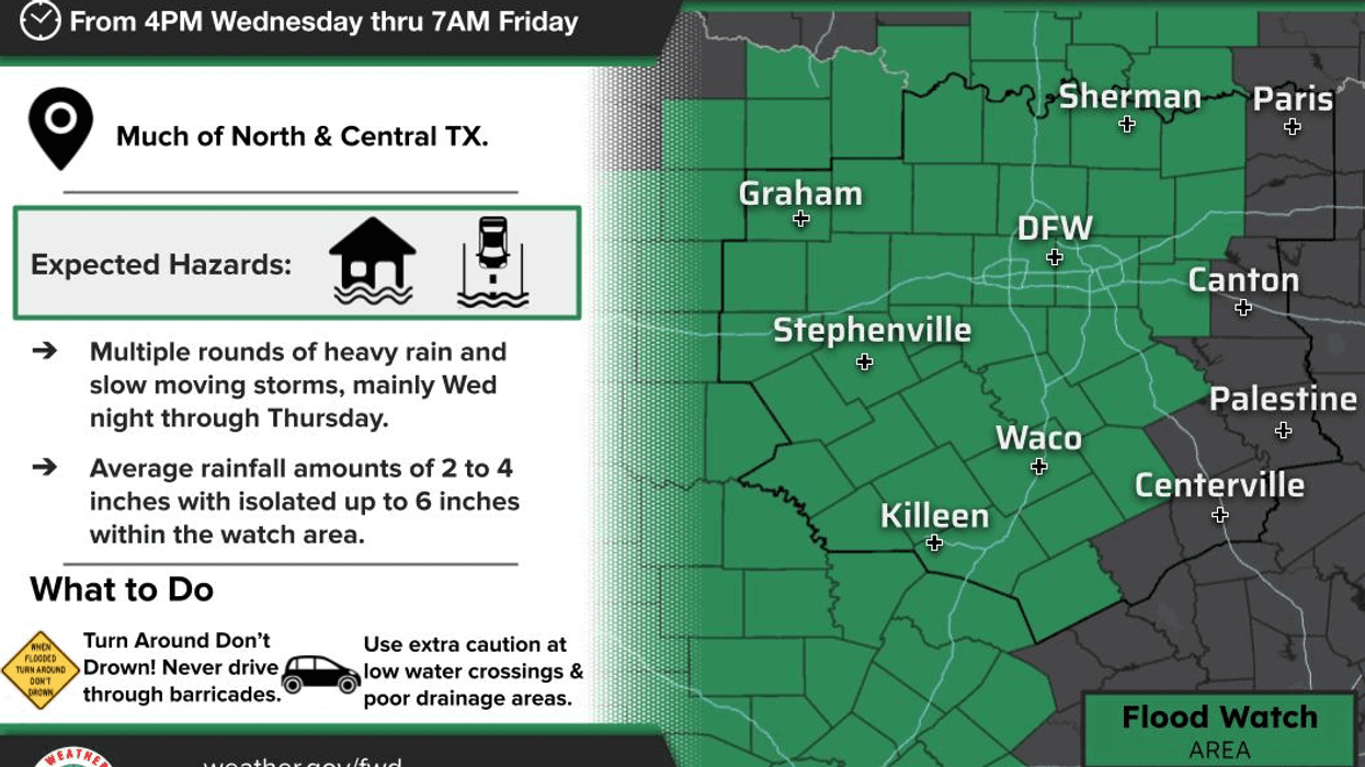
A Flood Watch will go into effect late this afternoon and continue into Friday morning. Several waves of rain and thunderstorms will move across North Texas from late this evening through Friday.
Here’s the big concern: our soil has been extremely dry, so it won’t be able to absorb all of this water quickly. A significant amount will run off into creeks, streams, lakes and rivers. That means flooding can develop much faster once the heavy rain begins.
MY BEST ADVICE:
If you don’t absolutely have to travel overnight tonight, DON’T.
And be prepared for a VERY, VERY messy Thursday morning commute. Give yourself extra time and NEVER drive through a flooded roadway.
Turn around, don’t drown!
TODAY:
We’re starting with temperatures in the 70s and clouds coming and going. It will be windy today, with south winds gusting around 35 mph. There will also be an increased fire danger until the rain begins moving in from the west late this afternoon and into this evening.
SEVERE WEATHER:
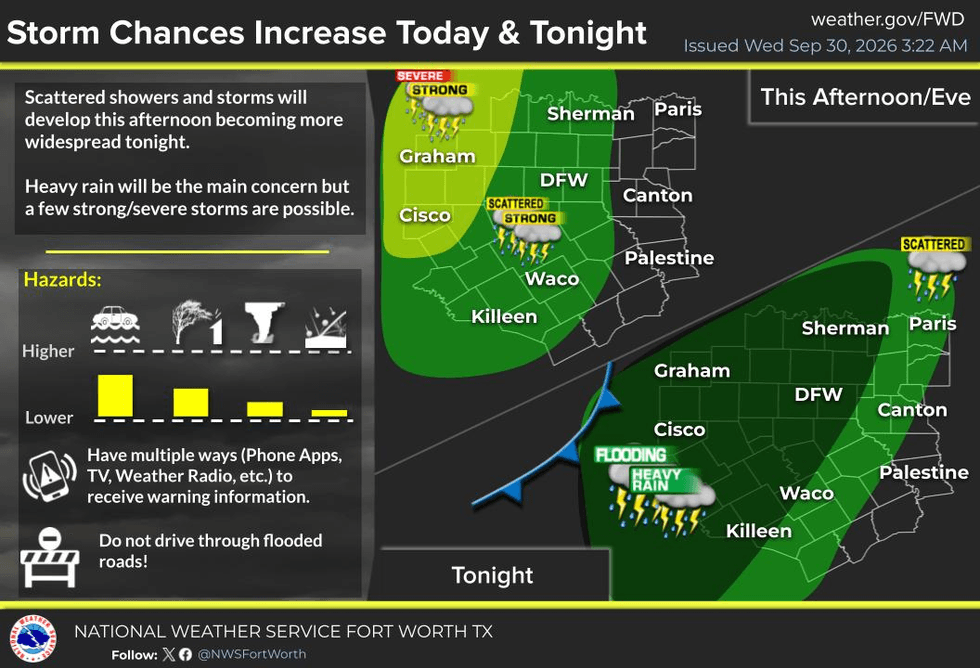
The Storm Prediction Center has Level 2 out of 5 — a SLIGHT Risk — for severe weather generally along and west of a Wichita Falls–Mineral Wells–Comanche line.
Could we see a few severe thunderstorm warnings along and west of the Denton–Fort Worth–Granbury line this evening? Absolutely.
Hail and damaging winds will be the primary threats, but with increasing wind shear, there could also be an isolated tornado or two, especially west of I-35W through midnight tonight.
Stay weather-aware!
THE GOOD NEWS:
You’re okay this morning. You’re okay this afternoon.
So get those errands done!
Go to the grocery store. Get the kids where they need to go. Take care of whatever you need to do before the heavy rain arrives tonight.
RAIN TIMELINE:
As the rain moves in late this afternoon and evening, it will become heavier overnight.
One to three inches of rain is possible through about noon Thursday, with locally heavier amounts — particularly west of the DFW Metroplex.
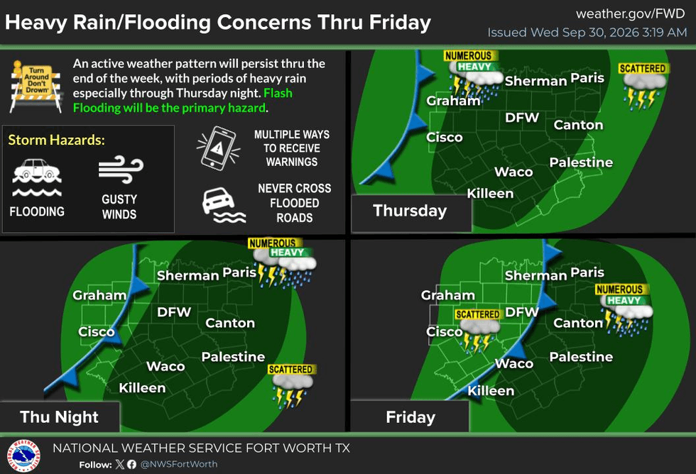
We may get a little break around the middle of Thursday afternoon, but don’t let your guard down. More scattered showers and thunderstorms could develop Thursday evening and continue into Friday.
A cold front will also move into the area. It’s NOT a Blue Norther, but it will help push the heaviest rainfall farther south of the Dallas-Fort Worth area late Thursday into Friday and Saturday.
Conditions should slowly improve Friday into Saturday, although scattered showers may still show up on the radar.
AND YES… IT’S FINALLY GOING TO GET COOLER!
Temperatures will fall into the 70s while it’s raining, and as the rain gradually tapers off this weekend, many of us should warm only into the lower 80s.
I’ll take that ANY DAY over the 90-degree-plus temperatures we’ve been dealing with for the last 103 days, including today!
And yes… that includes all those triple-digit days we experienced in July, August and early September!
BOTTOM LINE:
I don’t think this rainfall event is going to be quite as bad as some earlier forecasts suggested.
Two to four inches of rain will be possible across much of North Texas, with isolated higher totals possible, especially west and south of the Dallas-Fort Worth area.
The rain is coming — and after such a long, hot and incredibly dry stretch, North Texas certainly needs it.
But too much rain too quickly can create dangerous flooding.
PLEASE BE CAREFUL, ESPECIALLY TONIGHT AND THURSDAY MORNING!
As always, I appreciate everyone who follows my page!
Please LIKE and SHARE this post with your friends, family and coworkers. Let’s keep everyone informed and weather-aware!
Have a great Wednesday, everyone — and enjoy the weather when you can, it’s the only weather you've got!
7-Day Headlines:
- DFW Airport hit 95 degrees on Tuesday
- One more hot day ahead (90s)
- Flood Watch starts: 4pm Wednesday; Ends: 7am Friday
- Heavy rain threat late Wednesday into Thursday
- Rain chances continue Friday into the weekend
- Average rainfall totals: 2”-4”...isolated 4”-6”
- Cooler temperatures
- Low humidity next week
- Download our AUDACY app! Listen to KRLD LIVE at home or at work
Almanac:
- Yest Rain: 0.00”; Yest High: 95; Low: 77
- Today’s Averages: High: 84; Low: 64
- Record high: 98 (1953,1977); Record low 43 (1984)
- September rain: 0.01”; Deficit: <2.63”>
- 2026 Rain: 22.62”; Snow: 2.4”; Deficit: <4.57”>
- Sunrise: 7:22am; Sunset: 7:13pm
Forecast:
Wednesday: Increasing clouds, breezy and warm. **Flood Watch begins at 4pm**. Heavy rain moves in from the west by mid evening and continues overnight. Isolated severe (west of DFW before midnight). High: Low 90s. Wind: South 15-25, G35 mph.
Wednesday night: **Flood Watch** Cloudy, breezy and stormy! Heavy rain with thunder and gusty wind. (2”-3”). Low: Low 70s. Wind: South 15-25 mph
Thursday: **Flood Watch** Cloudy, breezy and cooler. Numerous showers and isolated strong storms through noon. Heavy rain and flooding threat early (1” of rain) High: Upper 70s. Wind: South 10-20 mph.
Friday: Morning cold front. Decent chance of showers and isolated storms (1” of rain). Flooding possible. High: Near 80.
Saturday: Mostly cloudy and mild. Scattered showers (0.50” of rain). High: Upper 70s.
Sunday: Partly cloudy, continued mild. A few leftover showers. High: Low 80s.
Monday and Tuesday: Mostly sunny and seasonable! Drier air FINALLY arrives. High: Low 80s.
LISTEN on the Audacy App
Tell your Smart Speaker to "PLAY 1080 KRLD"
Sign Up to receive our KRLD Insider Newsletter for more news
Follow us on Facebook | Twitter | Instagram | YouTube