UPDATE (7:00 P.M.): A severe thunderstorm watch remains in place for the following 10 counties in North Texas: Cooke, Hood, Montague, Young, Denton, Jack, Somervell, Erath, Johnson and Wise.
There is also a tornado warning in place for Denton County.
UPDATE: A Severe Thunderstorm Watch has been activated across North Texas thru 8 p.m. Friday evening.
The counties affected include Collin, Dallas, Denton, Kaufman, Rockwall, Tarrant, Travis, Williamson and Wise counties.
Temperatures are in the mid to upper fifties this morning and we're on our way up into the middle seventies later on this afternoon.
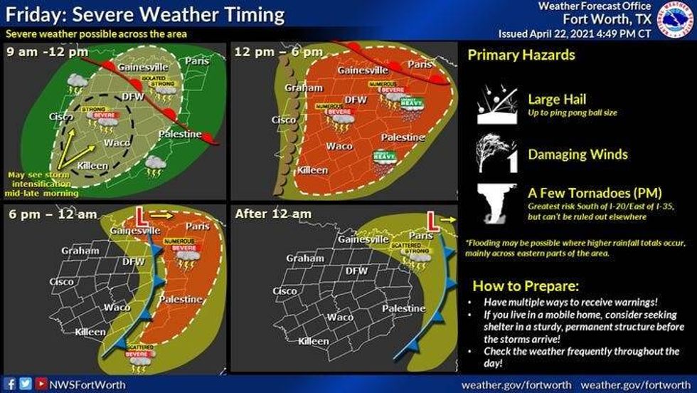
Please be weather aware roughly between noon and 6:00 p.m. across north Texas. Very large hail and damaging wind will be the threats, with an isolated tornado chance. The greatest chance, and it's not too high, for tornadic development will be east of interstate 45 and south of interstate 30 later this afternoon. Mainly in east Texas spreading into the northern half of Louisiana. There's also another small bullseye for tornadic development along the dry line late this afternoon from Wichita Falls, northwest to Childress and then into southwest Oklahoma.
 NWS
NWS
Make sure you have multiple ways to receiving warnings. Also, make sure your emergency alerts are switched to the "on" position on your smartphones. This way you'll get push notifications for any warnings that are issued for your neighborhood. Also, make sure you have downloaded the AUDACY App to your smartphones. This way, you can listen to KRLD any time, anywhere... 24/7.
To reiterate, my biggest concern will be for very large hail during that noon to 6:00 p.m. time frame.
There will be one more small chance for isolated severe storms late this evening through 3:00 a.m. as the cold front comes through the area. The greatest chance as of now, will be along and north of 380 stretching into Oklahoma. Damaging wind and small hail will be the threats.
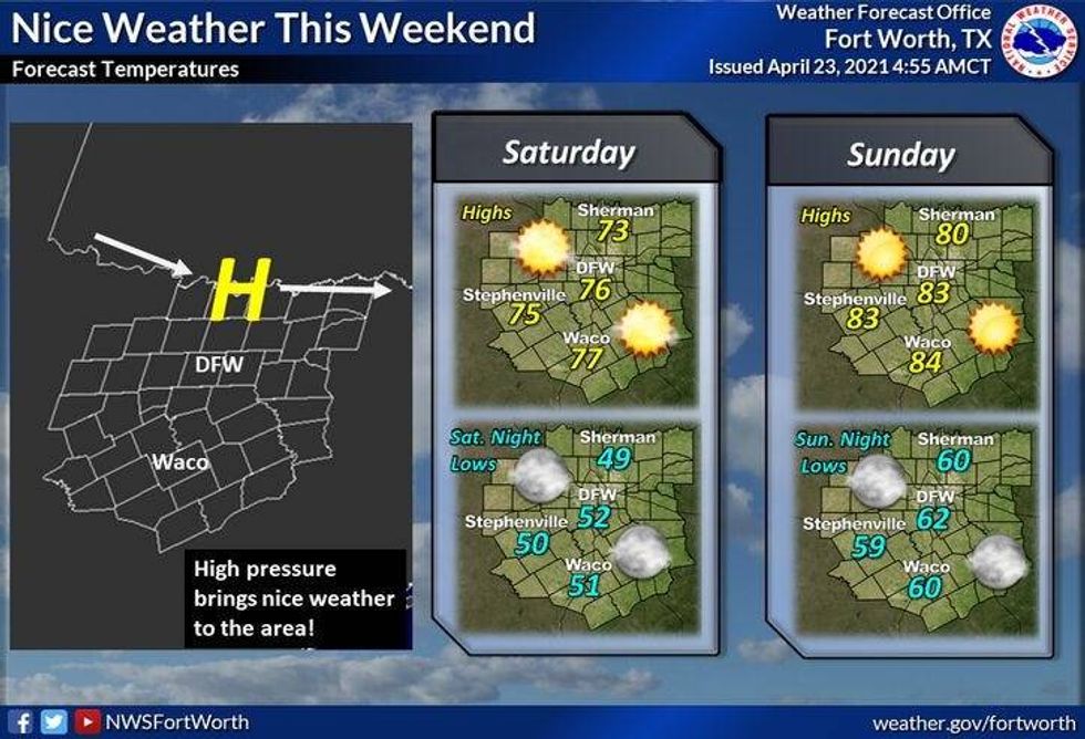
Good news: When you wake up tomorrow morning, all the rain will have pressed east of north Texas and skies will clear through the morning. I'm forecasting a very nice weekend for all of us!
 NWS
NWS
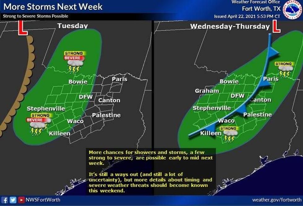
We really warm up into Monday and Tuesday of next week with highs in the middle eighties, before our next chance for severe storms arrives late Tuesday.
 NWS
NWS
Stay weather aware y'all and enjoy the weather, when you can, it's the only whether you've got!
7-Day Headlines:
* Level 2 (Slight risk) for severe weather today.
* Threats: Large hail and wind. Isolated tornadoes (SE of DFW)
* A nice weekend ahead!
* Warming up Sunday through Tuesday.
* More severe weather possible Tuesday.
__________________________________________________________
*Yest Rain: 0.00"; *Yest High: 65; Low: 54
*Today's Averages: High: 78; Low: 57
*Record high: 90 (1934); Record low: 41 (1907. 2013)
___________________________________________________________
*April rain: 1.72"; April deficit: ">
*2021 Rain: 7.82"; 2021 deficit: ">
*Sunrise: 6:49am; Sunset: 8:04pm
___________________________________________________________
Today: Numerous showers and storms. Some severe (Level 2 out of 5, SLIGHT RISK). Threats: Large hail, damaging wind, and isolated tornadoes. High: Low to mid 70s. Wind: SE 15-25 mph.
Tonight: Showers and isolated severe storms before midnight along cold front. Low: Low to mid 50s. Wind: SE to WNW 10-20, G25 mph.
Tomorrow: Mostly sunny, breezy and pleasant. Lower humidity. High: Mid 70s. Wind: North 15-25 mph.
Sunday: Mostly sunny, breezy and warmer. High: Low 80s.
Monday: Mostly cloudy, windy and warm. High: Low to mid 80s.
Tuesday: Mostly cloudy. Chance of thunderstorms. Some severe towards evening. High: Low to mid 80s.
Wednesday: Partly cloudy and cooler. Isolated showers and storms. High: Mid 70s.
Thursday: Sunny and pleasant. High: Mid 70s.