

Well, it's that time of year again. We're wrapping up July and heading into the hottest month of the year—August. Climatologically, this is when North Texas reaches its peak heat. The average low is now 77°, and the average high is 97°. Those averages hold steady through about August 15 before we slowly begin to cool as we inch closer to fall.
Good morning, everyone, and welcome to Tuesday!
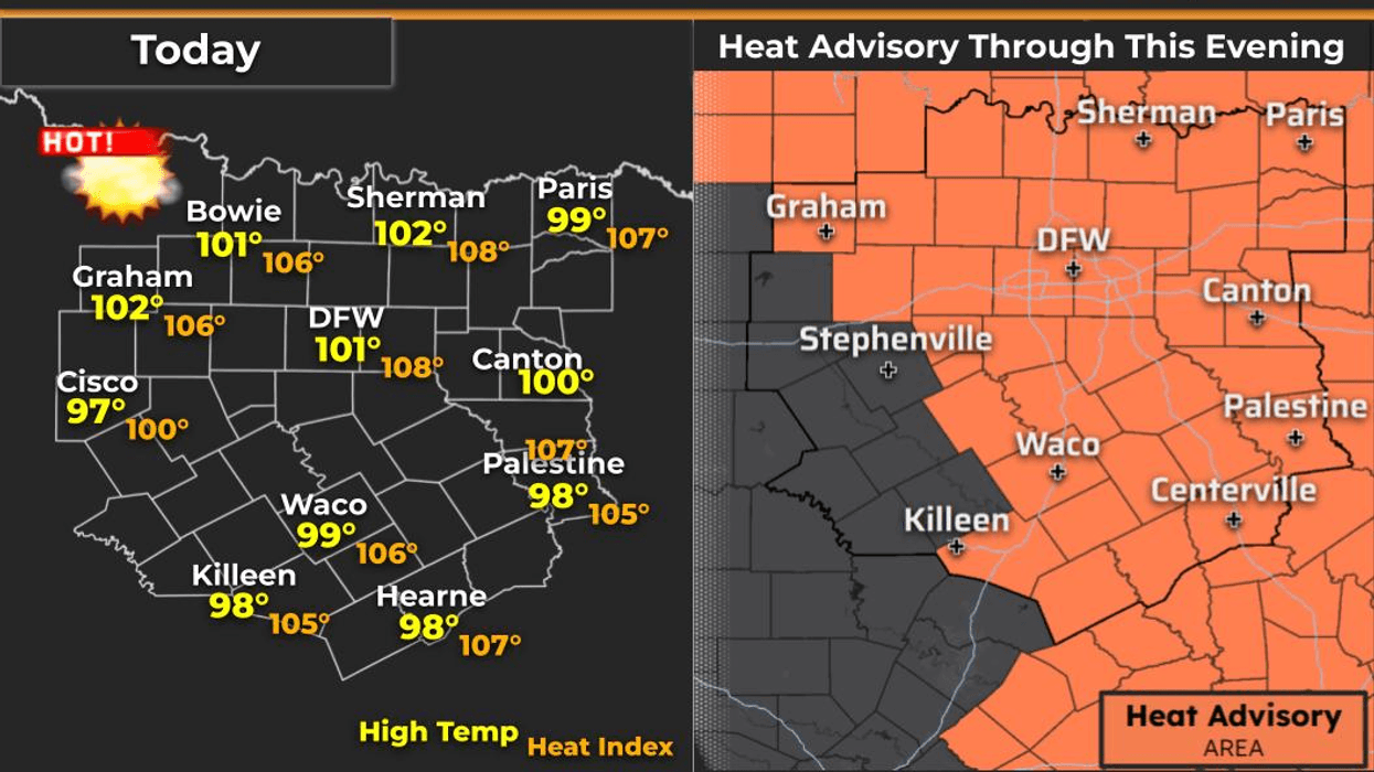
Yesterday, DFW topped out at 100°, making it the seventh 100-degree day of the summer so far. On average, we see 20 triple-digit days each summer, so we still have plenty of hot weather ahead.
Temperatures will warm to 101 today, 102 on Wednesday, 103 on Thursday.
The good news is a weak cold front will slide into North Texas Friday night. It won't bring much rain, but there is a very slight chance of a shower or thunderstorm mainly south of I-20 late Friday night into Saturday morning. Before the front arrives, Friday will likely be our hottest day of the week, with highs around 105° thanks to compressional heating ahead of the front, which will still be over Oklahoma Friday afternoon.
Behind the front, temperatures ease back into the upper 90s on Saturday, with highs around 97° on Sunday—right at average for this time of year. We'll be back close to 100° as we head into early next week.
With the dangerous heat continuing, remember to stay hydrated and take frequent breaks if you're working outdoors. Wear light-colored, loose-fitting clothing, along with sunscreen and a hat. Don't forget to check the back seat for children, and make sure pets have a cool place to stay during the hottest part of the day.
Have a great Tuesday, enjoy the weather when you can, and that's the latest weather you've got!
7-Day Headlines:
* DFW Airport reached 100 on Monday
* Heat Advisory today through 8pm
* More Heat Advisories through the week
* Triple digit temperatures continue through Friday
* A bit cooler Sunday and Monday
* Triple digits return this next week
* Please download our Audacy app. Listen to NewsRadio 1080am live anytime/anywhere
Almanac:
*Yest Rain: 0.00”; Yest High: 100; Low: 80
*Today’s Averages: High: 97; Low: 77
*Record high: 105 (1995, 2008); Record low 66 (1994)
*July rain: 1.36”; Deficit: <0.52”>
*2026 Rain: 22.61”; Snow: 2.4” Surplus: 0.44”
*Sunrise: 6.40am; Sunset: 8:29pm
Forecast:
Tuesday: **Heat Advisory** Mostly sunny and hot. High: 101. Heat index: 105+. Wind: South 5-10 mph.
Tuesday night: Mostly clear, warm and muggy. Low: Near 80. Wind: South 5-10 mph.
Wednesday: **Heat Advisory** Mostly sunny and hot. High: 102. Heat index: 105+. Wind: South 5-10 mph.
Thursday: **Heat Advisory likely** Mostly sunny and hot. High: 103. Heat index: 105+
Friday: **Heat Advisory likely* Mostly sunny and hot. Late evening cold front. Slight chance of showers. High: Near 105. Heat index: Near 109+.
Saturday: Partly cloudy and a bit cooler. A light chance of showers south of I-20. High: Upper 90s.
Sunday: Mostly sunny and hot. High: Upper Mid to upper 90s.
Monday: Mostly sunny and hot. High: Near 100.
LISTEN on the Audacy App
Tell your Smart Speaker to "PLAY 1080 KRLD"
Sign Up to receive our KRLD Insider Newsletter for more news
Follow us on Facebook | Twitter | Instagram | YouTube