More Heat Advisories will be in place across North Texas on Wednesday and Thursday before two cold fronts bring rain back to the area for the first time in more than three weeks.
Afternoon highs on Wednesday will be near 100 degrees, but when you factor in the humidity, it'll feel more like 105-108 during the peak heating hours. There is also a bit of Saharan dust in the air. It looks like all fireworks shows will be OK on Thursday evening, with the exception of the Red River Valley area.
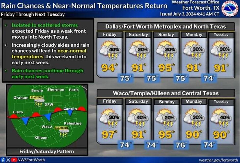
The first cold front will arrive early Friday morning bringing a chance for showers and storms. A large area of storms will form in Oklahoma late Thursday afternoon and evening and sag across the Red River Valley through the early morning hours on Friday. These will most likely weaken, but reform along the front during the afternoon and evening on Friday. Widespread coverage will form along this boundary, but it's still too early to say where this front will lay during the afternoon and evening hours. Afternoon highs will be cooler with readings struggling to get above 90 degrees.
It looks like the first front will be south of Interstate 20 on Saturday and move back to the north of DFW on Sunday. More afternoon-evening storms are possible through the weekend, all front location dependent. Highs this weekend will be near 90 degrees.
 North Texas weekend forecastNational Weather Service
A second front will edge to the area next Monday bringing more scattered showers and storms back to North Texas. Afternoon highs will struggle to reach 90 degrees again. Tuesday and Wednesday's forecasts are all dependent on the track of Hurricane Beryl.
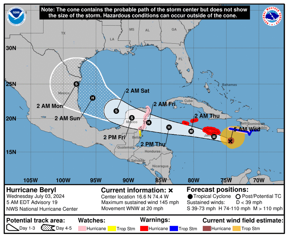
As of early Wednesday, Beryl's maximum sustained wind was still holding at 145 mph. This makes it a strong Category 4 hurricane as it makes a beeline for the southern shores of Jamaica. Five to ten inches of rain, a storm surge up to 10 feet and catastrophic wind damage are the threats.
Beryl's next stop will be on the Yucatan Peninsula on Friday morning. The Hurricane Center predicts Beryl will lose some of its punch as it approaches the eastern shores. Hurricane Watches are in place across the eastern Yucatan, north of Belize.
By Saturday morning, Beryl will have re-emerged in the southwestern Gulf of Mexico. The degree of uncertainty of Beryl's track expands greatly after that. All eyes from northeast Mexico to the middle Texas coast need to keep an eye on this storm late Sunday into Monday as it makes landfall.
 Hurricane Beryl trackNational Weather Service
7-Day Headlines
* DFW Airport reached 100 on Tuesday. 4th triple digit temperature this year.
* Beryl's wind at 145mph Wednesday morning, slams Jamaica this afternoon.
* Beryl heads to the Yucatan Friday and possibly the lower or middle TX coast late Sunday into Monday.
* Stalling Friday cold front brings storms and cooler temperatures.
* Scattered storms this weekend, mainly south of DFW.
* Watching Beryl's track next week. Could be a rainy week!!
_______________________________________________________
*Tuesday Rain: 0.00"; Tuesday High: 100; Low: 82
*Wednesday's Averages: High: 94; Low: 75
*Record high: 109 (1980); Record low: 64 (1924)
________________________________________________________
*July Rain: 0.00"; Deficit:
*2024 Rain: 28.74"; Surplus: 8.24"
*Sunrise: 6:25am; Sunset: 8:40pm
________________________________________________________
Wednesday: *Heat Advisory* Mostly sunny and hot. High: 101. Heat index: 105 - 109. Wind: South 10-20 mph.
Wednesday night: Clear, breezy, warm, and muggy. Low: Low 80s. Wind: South 10-20 mph.
Thursday: *Possible Heat Advisory* Partly cloudy, continued hot. Scattered storms after midnight. High: 101. Heat index: 105 - 109. Wind: South 10-20 mph.
Friday: Mostly cloudy and cooler. Scattered showers and some strong storms. Threats: Wind and lightning. High: Near 90.
Weekend: Partly to mostly cloudy and warm. Scattered showers and storms, mainly south of I-20. Isolated to the north. Highs: Near 90.
Monday: Partly to mostly cloudy. Scattered showers and storms. Watching Beryl's track. High: Near 90.
Tuesday: Cloudy, windy and mild. Scattered showers and storms. Watching Beryl's track. High: Upper 70s.
LISTEN on the Audacy App
Tell your Smart Speaker to "PLAY 1080 KRLD"
Sign Up to receive our KRLD Insider Newsletter for more news
Follow us on Facebook | Twitter | Instagram | YouTube