We're heating up today and tomorrow. Showers and thunderstorms return on Friday, we'll dry out for most of the weekend, and additional rain chances arrive early next week. Those are your weather stories over the next seven days.
Discussion:
Good morning, everyone, and welcome to Wednesday!
Most of North Texas is waking up under a clear sky this morning, although a few low clouds are trying to work northward from the Gulf. Temperatures are mild and muggy, generally in the mid to upper 70s.
Today will be sunny, hot, and humid. Afternoon highs will climb into the mid-90s, while heat index values approach 105 degrees in some locations. The good news is that south winds will increase to 15 to 25 mph, providing at least a little relief from the heat.
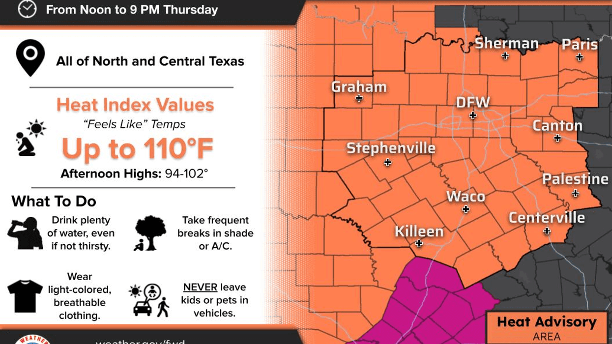
Thursday looks even hotter. We'll start the day with some morning clouds before sunshine takes over during the afternoon. High temperatures will range from 95 to 100 degrees, with the hottest readings expected west of Fort Worth. Heat index values will exceed 105 degrees across much of North Texas, and heat advisories will likely be needed area-wide.
The good news? This heat won't last long.
A cold front currently moving across the northern Plains will slowly push into North Texas on Friday. As it arrives, showers and thunderstorms will move out of Oklahoma and into north Texas, especially west of Interstate 35E. Severe weather appears unlikely at this time, but heavy rainfall, frequent lightning, and gusty winds are possible.
As we move through Friday afternoon and evening, the greatest coverage of showers and storms should shift east of Interstate 35E. Temperatures will struggle to get out of the mid to upper 80s, and some locations that remain under persistent rain may stay in the 70s all day.
After a few lingering morning showers Saturday, most of the weekend looks hot and dry. Highs will be near 90 degrees Saturday and return to the mid-90s by Sunday. Heat index values will once again top 100 degrees.
Looking ahead to early next week, rain chances increase as another cold front attempts to sag southward toward North Texas. The exact placement of the front will determine who receives widespread showers and thunderstorms and who sees only isolated activity. Right now, areas along and north of Interstate 20 appear to have the best opportunity for rain Monday and Tuesday.
Temperatures early next week will vary considerably. Areas experiencing rain may remain in the 70s, while locations seeing more sunshine could warm into the upper 80s and lower 90s.
Meanwhile, the system in the northwestern Gulf continues to slowly creep northeastward and is producing very heavy rainfall along the upper Texas Coast today through Thursday morning, along with gusty winds. There remains a slight chance that the system could briefly strengthen into a tropical storm. If that occurs, it would receive the name Arthur. Regardless of development, the system should move away from the upper Texas Coast by midday Thursday.
I hope everyone has a great day today and please enjoy the weather when you can, it's the only weather you've got!
— Dan the Weatherman
7-Day Headlines:
* DFW Airport reached 91 on Tuesday
* Heating up today and Thursday
* Heat index values exceed 100 degrees Wednesday
* Heat Advisory Thursday. Heat index 105+
* Scattered showers and storms return Friday into Saturday morning
* Mostly of the weekend is dry, hot and humid
* Scattered showers and storms return Monday and Tuesday
Almanac:
*Yest Rain: 0.00”; Yest High: 91; Low: 73
*Today’s Averages: High: 92; Low: 73
*Record high: 105 (1911); Record low 58 (1981)
*June rain: 7.40”; Surplus: 5.35”
*2026 Rain: 20.58”; Snow: 2.4” Surplus: 1.94”
*Sunrise: 6.20am; Sunset: 8:39pm
Forecast:
Wednesday: Morning clouds, afternoon sun. Breezy, hot and humid. High: Mid 90s. Heat index: Near 105. Wind: South 15-25 mph.
Wednesday night: Increasing low clouds. Mild, breezy and muggy. Low: Mid to upper 70s. Wind: South 15-25 mph.
Thursday: **HEAT ADVISORY** Morning clouds, afternoon sun. Breezy, hot, and humid. Scattered storms towards midnight. High: 95-100. Heat index: 105+. Wind: South 15-25 mph.
Friday: Morning storms. Highest coverage west of I-35E. Breezy and cooler. Leftover afternoon and evening showers and storms are possible. Highest coverage east of 35E. High: Mid 80s.
Saturday: Morning showers, becoming partly cloudy, warm and humid. Isolated afternoon showers and storms. High: Near 90. Heat index: Mid 90s.
Sunday: Mostly sunny, breezy, hot and humid. High: Mid 90s. Heat index low 100s.
Monday and Tuesday: Partly cloudy, hot and humid. Scattered showers and storms, mainly north of I-20. Highs: Low to mid 90s.