Above-average temperatures, breezy conditions, heat index values approaching 105°, and no rain until possibly early Friday morning.
Good morning, everyone, and welcome to Tuesday!
We're waking up to temperatures in the mid to upper 70s with a south wind gusting to around 20 mph. That southerly flow will continue to pull low clouds inland from the Gulf during the morning hours, so we'll call it mostly cloudy through mid- to late morning before sunshine breaks out this afternoon.
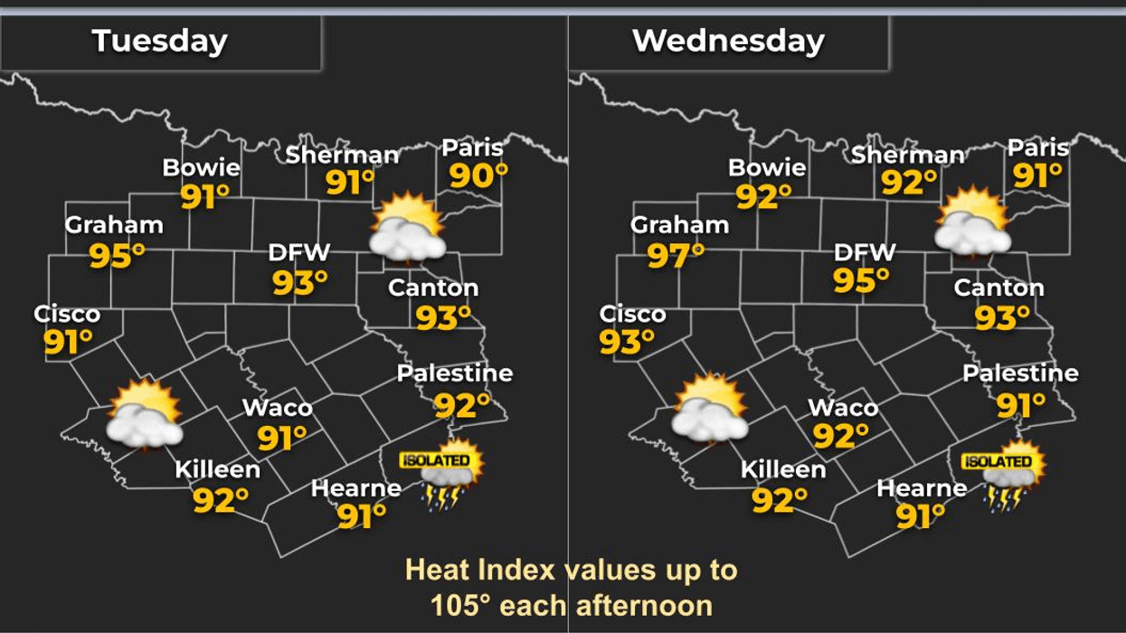
High temperatures will climb back into the mid-90s today. We reached 95° yesterday, and I expect similar temperatures both today and Wednesday. If you're working outdoors, be sure to stay hydrated and take frequent breaks. Also, make sure pets have plenty of water and are indoors during the hottest part of the day.
As we move into Wednesday and Thursday, not much changes. Afternoon highs will remain in the low to mid-90s with heat index values climbing above 100°. Despite the heat, no Heat Advisories are currently in effect.
Looking ahead, the upper-level wind pattern will gradually shift to a more northwesterly flow late this week and into the weekend. This will allow a cold front to slide south toward the Red River early Friday morning, where it may stall through much of the weekend.
Meanwhile, numerous thunderstorms are expected to develop across eastern Colorado, western Kansas, and portions of the High Plains Thursday through Saturday afternoon and evening. Some of these storm complexes may track southeast toward the Red River Valley during the overnight and early morning hours on Friday, Saturday, and Sunday.
I'll keep a close eye on the front's position, as even small shifts could determine how far south the rain chances extend. Don't be surprised if you hear a few rumbles of thunder and see some rain during the early morning hours this weekend.
By late Sunday into early Monday, the front may finally get the push it needs to move through North Texas. If that happens, a more widespread round of showers and thunderstorms with heavy rainfall could move across the area. In a northwesterly flow pattern, damaging wind gusts are often the primary threat, so I'll continue monitoring that potential as we get closer.
Early next week should bring somewhat cooler temperatures along with the possibility of lingering showers and thunderstorms into Monday and perhaps early Tuesday.
In the meantime, stay cool, stay hydrated, and enjoy the weather when you can—it's the only weather you've got!
— Dan Brounoff, Meteorologist
7-Day Headlines:- DFW Airport reached 95 on Tuesday
- Low to mid 90s through the weekend, heat index values 100-105
- Windy through the weekend
- Scattered morning showers and storms through Saturday, especially north of I-30
- Storm chances increase early next week
- Watching early next week cold front
- Yest Rain: 0.00”; Yest High: 95; Low: 78
- Today’s Averages: High: 91; Low: 71
- Record high: 102 (1911); Record low 59 (1955, 1978)
- June rain: 7.16”; Surplus: 6.09”
- 2026 Rain: 20.34”; Snow: 2.4” Surplus: 2.68”
- Sunrise: 6.19am; Sunset: 8:36pm
Tuesday: Morning clouds, afternoon sun, wind, and heat. High: Low to mid 90s. Heat index: 100-105. Wind: South 15-25, G30 mph.
Tuesday night: Partly cloudy, humid and breezy. Low: Mid to upper 70s. Wind: South 10-20 mph.
Wednesday: Morning clouds, afternoon sun. Windy and warm. High: Low to mid 90s. Heat index: 100-105. Wind: South 15-25,G30 mph.
Thursday: Morning clouds, afternoon sun. Windy and warm. High: Low to mid 90s. Heat index: 100-105.
Friday and Saturday: Morning showers and storms (especially north of Hwy 380. High: Low to mid 90s. Heat index: 100-105.
Sunday: Mostly to partly cloudy, hot and humid. Scattered storms by late evening. High: Low to mid 90s. Heat index: 100-105.
Monday: Scattered showers and storms. Cold front timing? Breezy and cooler. High: Upper 70s.