
**GOOD MORNING, NORTH TEXAS! HAPPY TUESDAY!**
Good morning, everyone! I hope you had a great Monday for Columbus Day and Indigenous Peoples’ Day!
**VERY WARM AND BREEZY WEATHER THROUGH THURSDAY!**
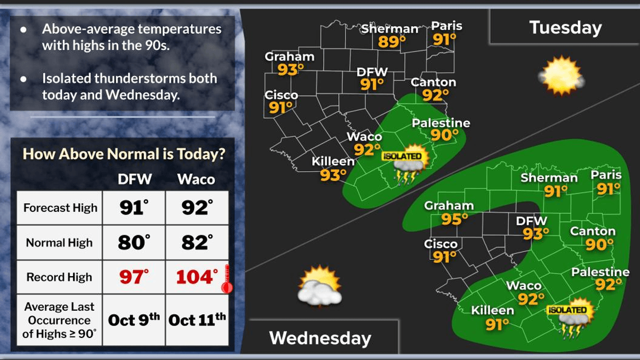
Get ready for a few more days of unseasonably warm temperatures across North Texas! We’ll have plenty of wind around today through Thursday, along with a slight chance of a few showers or an isolated thunderstorm late this afternoon and evening.
Most of that activity should stay south of the Dallas-Fort Worth area today and Wednesday, but a few of you could get lucky and see some much-needed rain!
**A BIG CHANGE IS COMING LATE THURSDAY!**
A strong cold front will move through North Texas late Thursday, bringing a dramatic change in temperatures just in time for the upcoming weekend!
Here’s what you can expect:
**FRIDAY MORNING:** Temperatures will drop into the 55–60-degree range, with strong north winds gusting up to 40 mph!
**FRIDAY AFTERNOON:** Highs will struggle to reach the mid-to-upper 60s. It will remain breezy throughout the day, so you’ll definitely want to grab a jacket!
**SATURDAY:** Another cool and breezy day, with temperatures gradually becoming more comfortable.
**SUNDAY MORNING:** Bundle up! Temperatures will dip into the upper 40s to mid-50s, with plenty of sunshine expected during the day.
**SUNDAY INTO MONDAY:** Sunshine returns, and temperatures will gradually warm back up, with highs climbing into the mid-70s by Monday!
**THE BOTTOM LINE:** Enjoy the summerlike warmth while it lasts, because a taste of fall is headed our way late this week! Those cooler temperatures should feel absolutely wonderful after everything we’ve been through this summer.
I hope everyone has a fantastic Tuesday!
**PLEASE LIKE AND SHARE THIS POST** with your friends, family, and neighbors so everyone can stay informed about the upcoming weather changes! Your shares help keep North Texas weather-aware and prepared!
And always remember...
**ENJOY THE WEATHER WHEN YOU CAN — IT’S THE ONLY WEATHER YOU’VE GOT!**
7-Day Headlines:
* DFW Airport reached 90 on Monday
* Above average temperatures through Thursday
* Heat index vales approach 100 degrees
* Isolated showers today and Wednesday south and east of DFW
* Scattered storms west of I-35W on Thursday. Evening STRONG cold front
* MUCH cooler Friday through the weekend!
* Please download our Audacy app. Listen to NewsRadio 1080am live anytime/anywhere
Almanac:
*Yest Rain: 0.00”; Yest High: 90; Low: 71
*Today’s Averages: High: 80; Low: 59
*Record high: 97 (1910); Record low 38 (1977)
*October rain: 3.84”; Surplus: 2.44”
*2026 Rain: 26.62”; Snow: 2.4” Deficit: <2.05”>
*Sunrise: 7:32am; Sunset: 6:56pm
Forecast:
Tuesday: Morning clouds, afternoon sunshine. Breezy and VERY warm. An isolated late-day shower or storm south and southeast of DFW. High: Low 90s. Heat index: Upper 90s. Wind: SE 10-20, G30 mph.
Tuesday night: Increasing clouds. Mild and muggy. Low: Mid 70s. Wind: South 10-20 mph.
Wednesday: Morning clouds, afternoon sunshine, An isolated late-day shower or storm. Warm, breezy, and humid. High: Low 90s. Heat index: Upper 90s. Wind: South 15-25 mph.
Thursday: Mostly cloudy, and warm Afternoon and evening showers a good bet, especially west of I-35W. STRONG late evening cold front! Turning VERY windy and cooler. High: Near 90..
Friday: Mostly to partly cloudy, VERY windy and MUCH cooler. Lows: 55-60; Highs: Mid to upper 60s. Wind: North 20-30, G40 mph.
Saturday: Partly cloudy, breezy and cool. High: Mid to upper 60s.
Sunday: Partly cloudy and perfect. Less wind. High: Mid 70s.
Monday: Mostly cloudy and pleasant. A slight chance of showers. High: Mid to upper 70s.
LISTEN on the Audacy App
Tell your Smart Speaker to "PLAY 1080 KRLD"
Sign Up to receive our KRLD Insider Newsletter for more news
Follow us on Facebook | Twitter | Instagram | YouTube