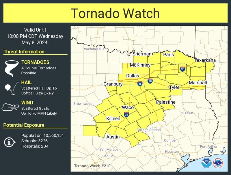

A TORNADO WATCH has been issued for parts of North Texas. It is in effect until 10:00 p.m. The counties under watch are below.

Wednesday started with low clouds, humidity, and mild temperatures for this time of the year. Readings only fell into the mid to upper 70s, with a south wind at 10 to 15 mph.
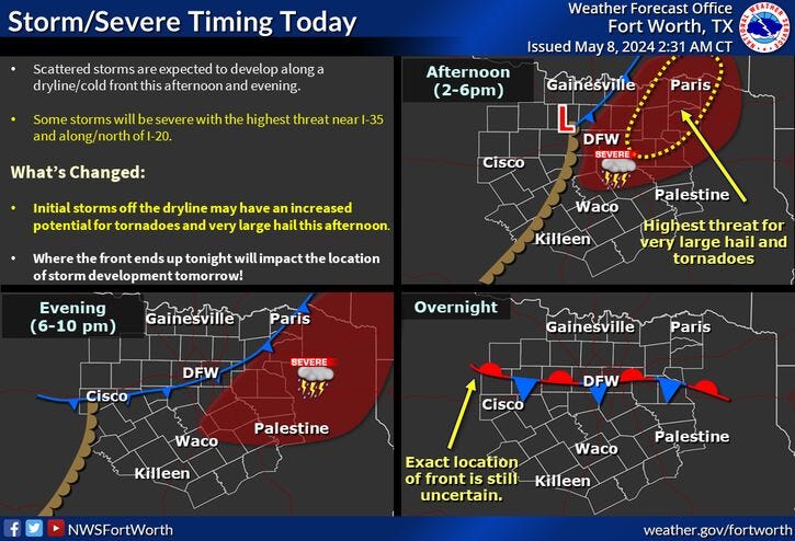
This low cloud cover will give way to a partly cloudy sky in the afternoon with highs in the low 90s. Heat index values will approach 100 degrees. To make matters worse, the dryline will surge into North Texas Wednesday afternoon, sparking scattered showers and severe storms along and east of Interstate 35W. Large hail, damaging wind, and isolated tornadoes are the threats. Please stay weather aware from 4-9 p.m.
Things will calm down Wednesday night with low clouds moving back into the area and a cold front approaching from the northwest. Morning lows will range from the low 60s to mid-70s from north to south.
This cold front will stall over North Texas Thursday afternoon and will be the focal point for more severe storms to break out. Areas between U.S. Highway 380 and Interstate 30 have a slight chance of severe weather and areas along and south of Interstate 30 have the greatest chance for severe storms. Stay weather-aware Thursday from 4-9 p.m.
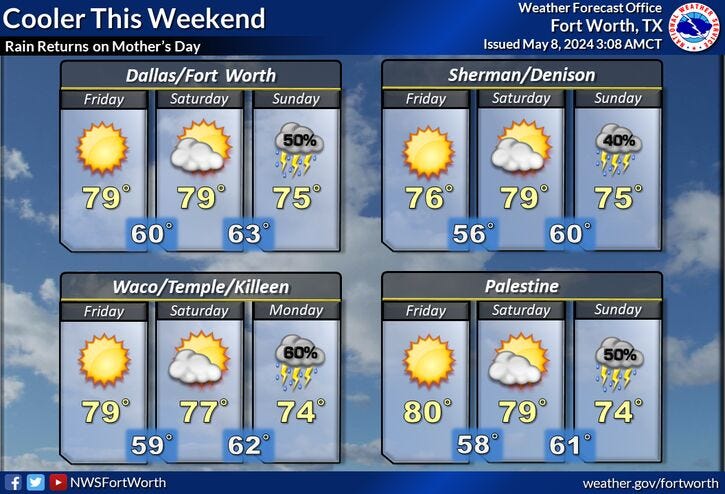
The cold front will move south of Dallas-Fort Worth late Thursday night and give way to a beautiful Friday afternoon: low humidity, plenty of sunshine with afternoon highs near 80 degrees.
Mother's Day weekend will start off beautifully. Plenty of sunshine Saturday with highs near 80 degrees again. Clouds will increase on Saturday night.
The next disturbance arrives on Mother's Day. There's a decent chance of scattered showers and nonsevere thunderstorms off and on during the day. Afternoon highs will be cooler due to the cloud cover with readings only in the mid-70s.
Depending on the speed of Sunday's disturbance will depend on whether we see leftover showers and storms on Monday. Highs will approach 80 degrees.
Morning clouds and afternoon sun for Tuesday with highs in the mid-80s.
7-Day Headlines
* DFW Airport reached 91 Tuesday.
* Severe storm threat Wednesday and Thursday.
* Wednesday's threat (Large hail, isolated tornadoes, wind): Mainly east of a Sherman to Mid Cities to Granbury line.
* Thursday's threat (Large hail, isolated tornadoes, wind): Along stationary front.
* Cooler/drier air Friday - Saturday.
* Storms returning Mother's Day into Monday.
_____________________________________________________
*Tuesday Rain: 0.00"; Yest High: 91; Low: 73
*Wednesday’s Averages: High: 81; Low: 62
*Record high: 95 (1933) Record low: 44 (1958)
________________________________________________________
*May Rain: 2.28"; Surplus: 1.23"
*2024 Rain: 19.55"; Surplus: 6.69"
*Sunrise: 6:34am; Sunset: 8:16pm
________________________________________________________
Wednesday: Morning clouds, afternoon sun. Warm and humid. Chance of showers and isolated severe storms (4pm-10pm, all modes), SE half of north Texas. High: Low 90s. Heat index: Near 100. Wind: South 15-25, G30 10 mph.
Wednesday night: Scattered evening severe storms, otherwise increasing low clouds after midnight. Cold front stalls. Low: 65-72. Wind: Variable 10-20 mph.
Thursday: Morning clouds, afternoon sun. Scattered afternoon and evening severe storms along a stalled cold front (Mainly south of US 380, Mckinney, Denton, and Decatur). Threats: Large hail, wind, and very isolated tornadoes. High: 80- 90. Wind: Variable 10-15 mph.
Friday: Mostly sunny and nice! Lower humidity. High: Upper 70s.
Saturday: Mostly sunny and pleasant. High: Near 80.
Mother's Day: Partly to mostly cloudy. Scattered showers and storms. HIgh: Mid 70s.
Monday: Leftover showers and storms. High: Low 80s.
Tuesday: Partly cloudy and warmer. High: Mid 80s.
LISTEN on the Audacy App
Tell your Smart Speaker to "PLAY 1080 KRLD"
Sign Up to receive our KRLD Insider Newsletter for more news
Follow us on Facebook | Twitter | Instagram | YouTube