
Record Heat Yesterday, Weather Changes Ahead This Week
Good morning, everyone! I hope you had a great weekend and managed to stay as cool as possible.
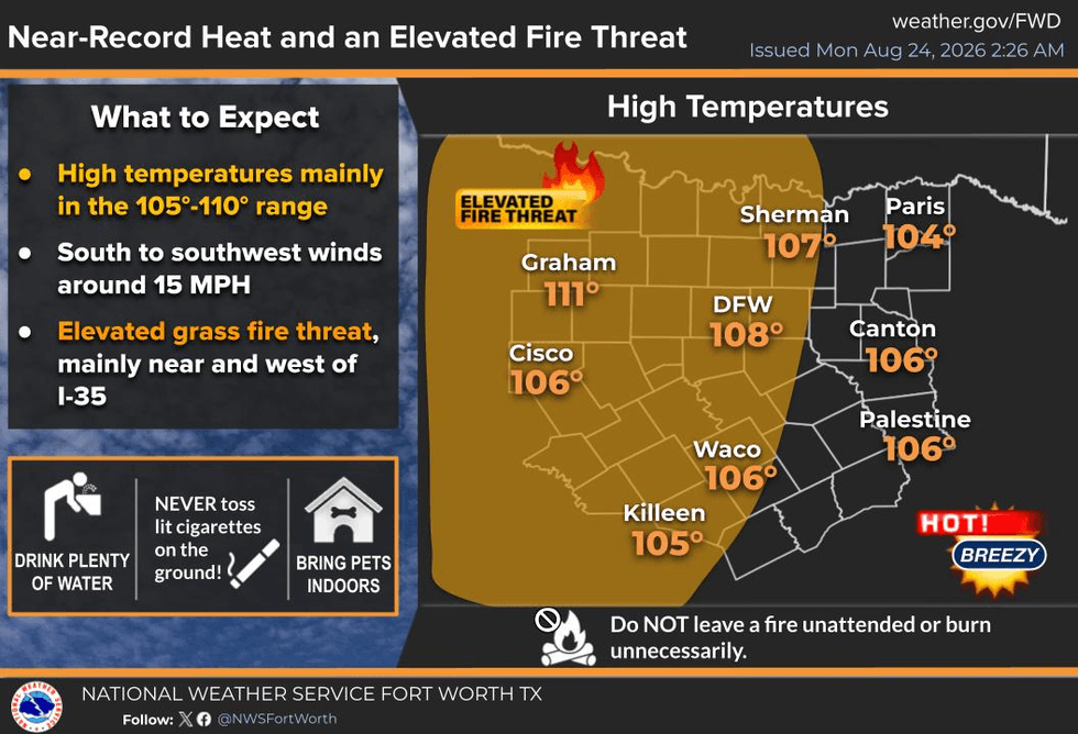
We set a new record high at DFW Airport yesterday when temperatures soared to 109 degrees. Today's record is 107 degrees, and we will come very close to tying or breaking that record as this dome of high pressure continues to grip North Texas.
We're waking up to temperatures in the low 80s this morning, with just a few clouds across the sky. Temperatures will quickly climb, with afternoon highs around 107 degrees, and we could even get a little hotter.
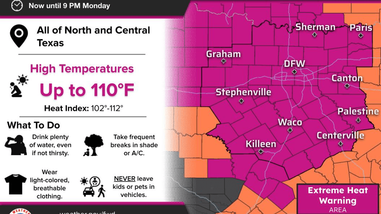
Please take this heat seriously. Heat warnings remain in effect across North Texas and will most likely be extended into Tuesday.
Speaking of Tuesday, a weak disturbance will move through the area, bringing some additional clouds to North Texas during the morning. There may also be a few thunderstorms developing across Oklahoma. We'll have to see if those storms survive the trip south or weaken and evaporate before reaching North Texas.
Tuesday afternoon will still be extremely hot, with highs around 105 to 106 degrees.
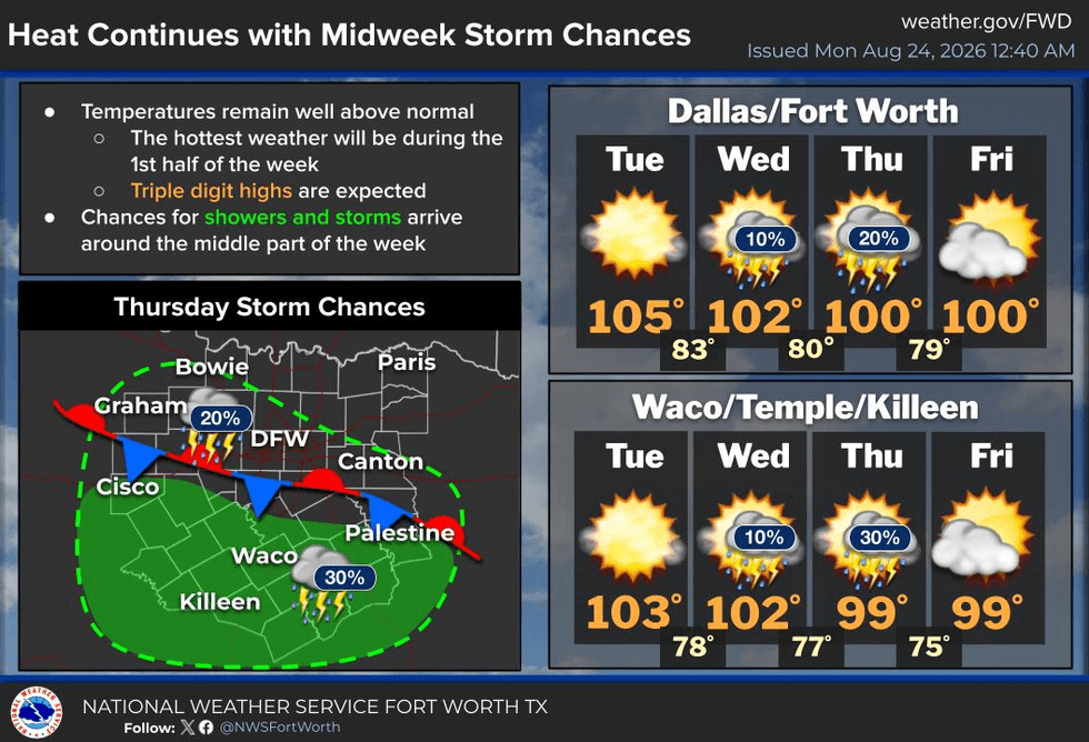
Wednesday will be a little cooler, with highs around 103 to 104 degrees. However, a strong upper-level disturbance will move in from the Northwest during the day. By Wednesday evening, numerous showers and thunderstorms could develop as that system approaches.
The big question will be whether those storms can penetrate the strong ridge of high pressure. They will likely weaken as they move into North Texas, but I'm still expecting around 40% coverage Wednesday evening.
Some showers and storms could linger, especially across the western counties, into Thursday. Temperatures should cool further, with highs around 103 degrees Wednesday and closer to 100 degrees Thursday.
Unfortunately, the heat dome will begin rebuilding by the end of the week and into next weekend. Temperatures will climb back to near 102 degrees Friday through the weekend, although it does not appear we'll be quite as hot as we are right now.
We're getting closer and closer to September, but the heat has certainly made it feel like summer is refusing to let go. DFW has recorded 29 triple-digit days so far this summer, and today will be another major test.
We're also approaching 39 consecutive days without measurable rainfall at DFW Airport. Hopefully, we can finally break that streak before the end of the week.
Stay cool, my friends. Please take this heat seriously, stay hydrated, limit your time outdoors during the hottest part of the day, and enjoy the weather whenever you can.
That's the only weather you've got!
7-Day Headlines:
- DFW Airport hit 109 degrees on Sunday. NEW record!
- 29 triples this summer
- 38 days with no measurable rain at DFW
- Top 10 hottest August
- Heat Warnings continue
- Slight rain chance early Tuesday, Wednesday evening and Thursday
- Triple digits through this weekend
- Download our AUDACY app! Listen to KRLD LIVE at home or at work
Almanac:
- Yest Rain: 0.00”; Yest High: 109; Low: 84
- Today’s Averages: High: 95; Low: 75
- Record high: 107 (2023); Record low 60 (1961)
- August rain: Trace; Deficit: <1.48”>
- 2026 Rain: 22.61”; Snow: 2.4”; Deficit: <1.24”>
- Sunrise: 6:58am; Sunset: 8:02pm
Forecast:
Monday: **Extreme Heat Warning** Mostly sunny and hot. High:108. Heat index:110. Record high: 107 (2023). Wind: South 10-20 mph.
Monday night: Passing clouds and warm. Low: Low to mid 80s. Wind: South 10-20 mph.
Tuesday: **Possible Heat Warnings** A few morning sprinkles north of DFW, otherwise partly cloudy and hot. High: 107. Record is 110 (2023).
Wednesday: **Possible Heat Warnings** Isolated afternoon and evening showers and storms. Partly cloudy and hot. High: 104.
Thursday: **Possible Heat Advisories** Isolated afternoon and evening showers and storms (mainly south of DFW). Partly cloudy and a tad cooler. High: 101.
Friday: **Possible Heat Advisories** Mostly sunny and hot. High: 102.
Weekend: **Possible Heat Advisories** Mostly sunny and hot. High: 102.