
Good morning, everyone! Welcome to almost Friday!
High pressure remains firmly in control across North Texas, and that will continue to be our big weather story through the middle of next week. We may see a slight rain chance late this evening, with another chance late Friday.
We’ve had plenty of triple-digit heat this month. In fact, we’ve only failed to reach 100° three times so far in August. For the summer, DFW Airport has now recorded 26 days at 100° or higher.
Even more concerning, DFW has gone 35 consecutive days without measurable rain. That could finally change late Friday afternoon and evening, although rain chances remain quite low.
A weak cold front is slowly moving through Oklahoma this morning, with scattered showers and storms developing along it. By Friday morning, areas along and east of a Sherman-to-Dallas line may have a slightly better chance of seeing a few storms. By Friday afternoon and evening, isolated storms could develop across North Texas.
Rain chances are only around 25% because the air is very dry, and some of the rainfall may evaporate before reaching the ground. If a storm develops near you, strong gusty winds, lightning, and brief heavy rain will be the main threats.
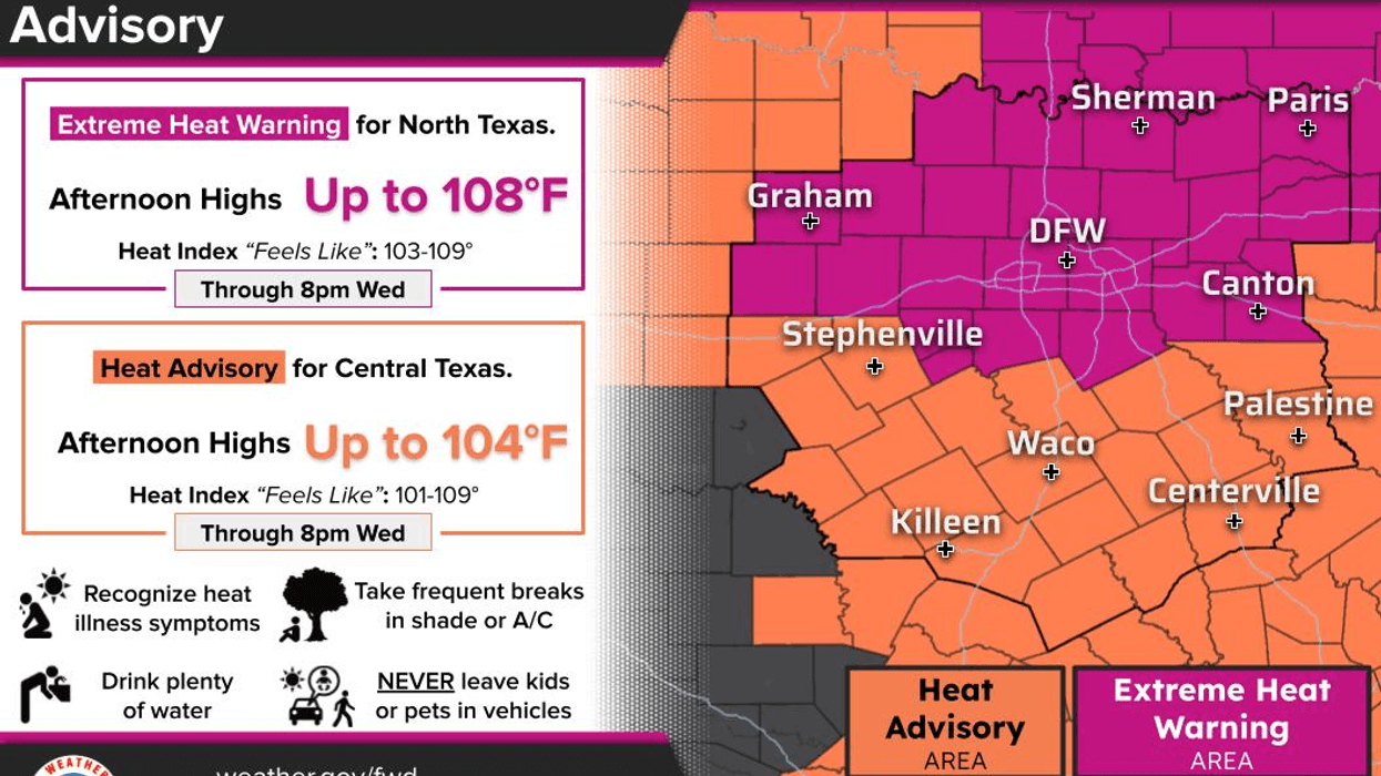
As for temperatures, we're looking at 105° to 106° today. Friday's record high is 106°, so we could tie or even break that record.
Expect around 104° Saturday before temperatures climb back toward 106° Sunday through the middle of next week.
The extended models continue to hint at a possible pattern change toward the end of next week, potentially bringing better rain chances and cooler temperatures.
We're getting closer to September, and fall officially begins September 22. Until then, stay cool, stay hydrated, check on your pets and loved ones, and enjoy the weather when you can.
7-Day Headlines:
- DFW Airport hit 105 degrees on Wednesday
- 26 triples this summer
- 35 days with no measurable rain at DFW
- Top 10 hottest August
- Heat Warnings continue
- Slight rain chance late Thursday-Saturday
- Triple digits through next week
- Download our AUDACY app! Listen to KRLD LIVE at home or at work
Almanac:
- Yest Rain: 0.00”; Yest High: 105; Low: 83
- Today’s Averages: High: 96; Low: 76
- Record high: 109 (2023); Record low 58 (1940)
- August rain: Trace; Deficit: <1.17”>
- 2026 Rain: 22.61”; Snow: 2.4”; Deficit: <0.93”>
- Sunrise: 6:56am; Sunset: 8:06pm
Forecast:
Thursday: **Extreme Heat Warning** Partly cloudy and hot. Isolated late day showers and storms (mainly east of Central Expressway) High:105. Heat index:108. Wind: South 5-10 mph.
Thursday night: An evening shower or storm possible. Partly cloudy and warm. Low: Low 80s. Wind: South 5-10 mph.
Friday: **Possible Heat Warning** Partly cloudy and hot. Scattered evening showers and storms.. High: 107. Record is 106.
Saturday: **Possible Heat Warnings** Isolated afternoon and evening showers and storms. Mostly sunny and hot. High: 106.
Sunday: **Possible Heat Warnings** Mostly sunny and hot. High: 106.
Monday - Wednesday: **Possible Heat Warnings** Mostly sunny and hot. High: 106.
LISTEN on the Audacy App
Tell your Smart Speaker to "PLAY 1080 KRLD"
Sign Up to receive our KRLD Insider Newsletter for more news
Follow us on Facebook | Twitter | Instagram | YouTube