
Hello everyone! It's great to be back on the air! Over the next 7 days, North Texas can expect a whole bunch of NOTHING in terms of weather activity. Warm days and mild nights with no rain in the forecast. I should stop here but I'll keep going. LOL!
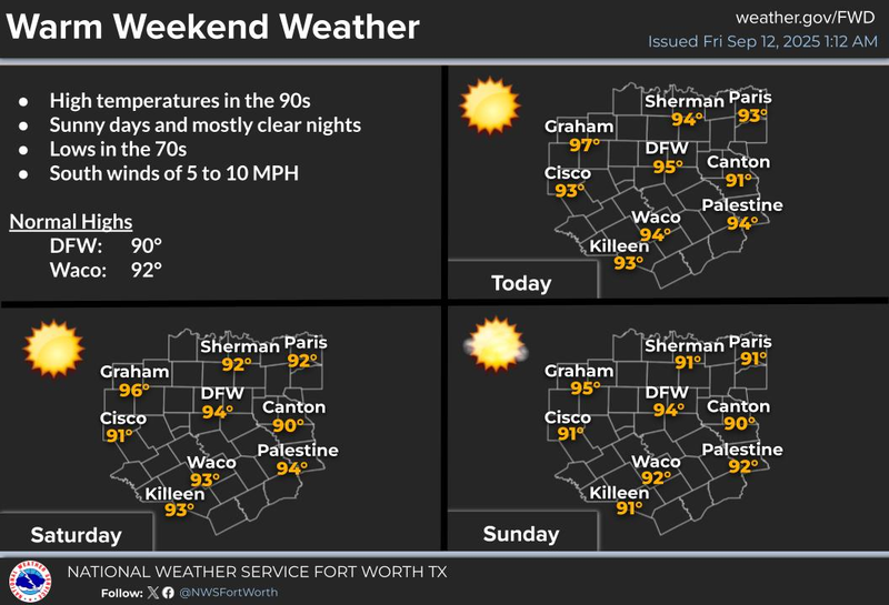
We're waking up to temperatures in the 70s this morning with a light southwesterly wind under a clear sky. Temperatures will warm up into the mid-90s today with a southwest wind at 10 to 15 mph.
A ridge of high pressure centered just to the east of North Texas will continue to dominate our weather through the weekend. One thing you will notice is high cloud streaming in from the west as a system affects the western quarter of the state Saturday and Sunday. This is where the rain will fall. Rain will form in New Mexico Saturday afternoon and move into these areas, including Amarillo, Lubbock, the Midland/ Odessa area, and far west Texas. The good news is that no rain will impact high school football across much of the state Friday evening. Make sure you dress appropriately for temperatures near 90 for kickoff.
Afternoon highs through the weekend will be in the low to mid-90s across North Texas. This bubble of high pressure isn't going anywhere anytime soon. Mild morning lows in the 70s with afternoon highs in the low to mid-90s pretty much every day next week, but no rain in the forecast. This pattern may slowly change in about 9 to 10 days as a cold front will be flirting with the area. This may cause compressional heating, not this weekend, but next weekend. So, I cannot rule out temperatures approaching 100 degrees again. Oh well!
The Gulf and Caribbean are quiet with no tropical activity expected over the next several days, however, there is a pretty strong disturbance coming off the African Coast. The Hurricane Center is monitoring this for possible development after day 5. It will be moving west-northwest and may impact the Leeward Islands and Lesser Antilles in about a week or so. Stay tuned.
Have a terrific day today, a splendid weekend, and please enjoy the weather when you can, it's the only weather you've got!
7-Day Headlines:
* DFW Airport reached 93 on Thursday.
* Upper level high pressure in control.
* Hot days, mild nights.
* Short sleeves, shorts and sandals for highschool and college football.
* No rain over the next 7 days.
* Possible weather change in 9 days.
*Yest Rain: 0.00"; Yest High: 93; Low: 68
*Today’s Averages: High: 90; Low: 70
*Record high: 103 (2011); Record low: 50 (1902)
*September Rain: 0.69"; Deficit:
*2025 Rain: 27.74"; Surplus: 2.10
*Sunrise: 7:11am; Sunset: 7:57pm
Friday: **Air Quality Alert** Mostly sunny and warm. High: Low to mid 90s. Wind: SW 10-15 mph.
Friday night: Clear and mild. Low: Mid 70s. Wind: SSW 5-10 mph.
Weekend: HIgh clouds and warm. High: Low to mid 90s. Wind: SSW 10-20 mph.
Monday - Thursday: Partly cloudy and warm. High: Low to mid 90s.
LISTEN on the Audacy App
Tell your Smart Speaker to "PLAY 1080 KRLD"
Sign Up to receive our KRLD Insider Newsletter for more news
Follow us on Facebook | Twitter | Instagram | YouTube