
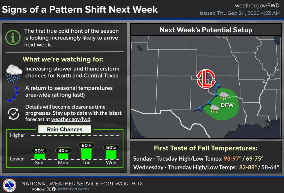
I know everybody is really, really curious about when it will finally start to feel like fall here across North Texas. If you can just be patient, I don't want to say that in about another five to six days, we'll finally start to feel some signs of fall, and some of us may even see some rain by the middle part of next week.
Good morning, everyone, and welcome to almost Friday. I hope everyone has had a great work week.
You won't need your umbrella anytime soon, I can guarantee you that. But you will need sunscreen, a ton of water, and light-colored, loose-fitting clothing if you're heading out to the opening weekend of the State Fair of Texas.
My best advice if you're going to the Fair is to find some air conditioning whenever you can. Go into the Automobile Building, check out all those new vehicles, and spend some time shopping in the buildings with all the vendors. You're definitely going to want some breaks from the heat.
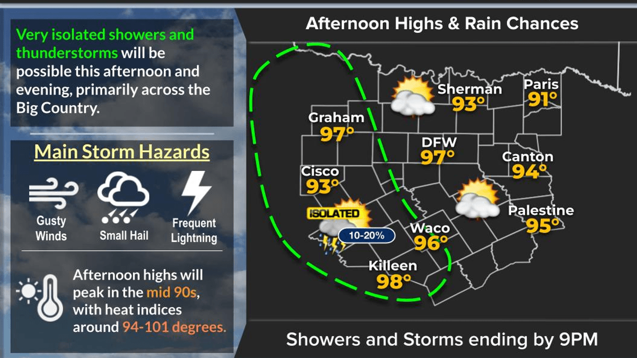
We'll be well into the 90s here Thursday, Friday, Saturday, Sunday and Monday — basically the next five days. Unfortunately, add about five degrees to those temperatures when you factor in the heat index. Morning temperatures will be relatively comfortable, in the low to mid-70s, but the afternoons are going to be hot.
All of the active weather across the state over the past couple of days has been occurring in areas that really need the rain, just like we do. That's especially true across the Panhandle, South Plains and West Texas, where flood watches continue from the Davis and Guadalupe Mountains up toward the El Paso area. Some locations have picked up several inches of rain.
If you're heading that direction, expect some travel delays. And if you're flying into Amarillo or Lubbock, be sure to check with your airline because scattered thunderstorms will continue to affect those areas.
For us here in North Texas, no rain for the rest of the week and into the weekend. We may want to add Monday to that as well.
Some of our western counties late tomorrow and Saturday may see a few showers and thunderstorms, with the better chances generally west of Highway 281. That activity is associated with the system impacting West Texas and New Mexico before moving into the Central Plains and away from the Lone Star State.
Now, here's the good news.
We may need to tweak the timing a little bit depending on how quickly the remnants of Hurricane Polo move across the region. Polo will be weakening as it moves inland, and it has to cross a tremendous amount of mountainous terrain in northern Mexico, so a lot of its moisture will likely be disrupted or lost.
However, there may be enough moisture left over, combined with an upper-level disturbance coming out of the Desert Southwest early next week, for those two systems to essentially shake hands and bring some much-needed rain to a good portion of Texas.
It's still way too early to talk about exactly how much rain we'll get or how widespread it will be, but there are indications that rain could develop across Texas from west to east Tuesday and Wednesday, possibly lingering into South Texas Thursday.
And here's the part I've really been waiting to talk about: that system should also drag a good, strong first fall cold front through the state.
Not just here in DFW, but across much of Texas.
So by the end of next week, we're actually looking at the potential for below-normal temperatures. We're talking highs in the 70s across North Texas and possibly the northern half of the state, 80s farther south, with morning lows in the 50s across the Panhandle and 60s across much of the rest of the state.
So you've got to wait another five to seven days, but it is coming.
In the meantime, make sure you stay hydrated. Wear light-colored, loose-fitting clothing if you're heading out to the State Fair of Texas this opening weekend. The same goes for high school football and college football. Stay hydrated, dress appropriately for the heat, and don't forget the sunscreen.
I'm Meteorologist Dan Brounoff in the KRLD Weather Center. Please enjoy the weather when you can. It's the only weather you've got.
Have a great day!
7-Day Headlines:
- DFW Airport hit 98 degrees on Wednesday
- 52 triples this summer
- Above average temperature through next Monday
- Hot and dry for the State Fair this weekend
- Pattern change arrives next Tuesday into Wednesday
- Increasing rain chances and cooler temperatures
- Download our AUDACY app! Listen to KRLD LIVE at home or at work
Almanac:
- Yest Rain: 0.00”; Yest High: 98; Low: 76
- Today’s Averages: High: 86; Low: 66
- Record high: 102 (2023); Record low 49 (1989)
- September rain: 0.01”; Deficit: <2.16”>
- 2026 Rain: 22.62”; Snow: 2.4”; Deficit: <4.10”>
- Sunrise: 7:18am; Sunset: 7:21pm
Forecast:
Thursday: Partly cloudy and hot. High: Mid to 90s. Wind: ESE 5-10 mph.
Thursday night: Partly cloudy and mild. Low: Mid to upper 70s. ESE 5-10 mph.
Friday: Opening Day of The State Fair of Texas. Partly cloudy and hot. High: Low to mid 90s.
Weekend: Partly cloudy, continued warm. Highs: Mid to upper 90s.
Monday: Partly cloudy and hot. High: Mid 90s.
Tuesday: Increasing clouds and cooler. Scattered showers and storms FINALLY return. High: Mid 80s.
Wednesday: Mostly cloudy and cooler. Scattered showers and storms. High: Near 80.
LISTEN on the Audacy App
Tell your Smart Speaker to "PLAY 1080 KRLD"
Sign Up to receive our KRLD Insider Newsletter for more news
Follow us on Facebook | Twitter | Instagram | YouTube