Good morning, everyone, and welcome to Tuesday! I hope you had a great Monday.
We're settling into a hot and fairly quiet weather pattern that will stick around through the end of the week, into the weekend, and likely for much of next week. High pressure in the upper levels of the atmosphere will continue to dominate our weather, keeping temperatures above average for this time of year.
Yesterday, DFW Airport officially reached 101°. Thanks to the relatively lower humidity, the heat index actually stayed a couple of degrees below the air temperature. That will begin to change, though, as humidity slowly increases through the rest of the week.
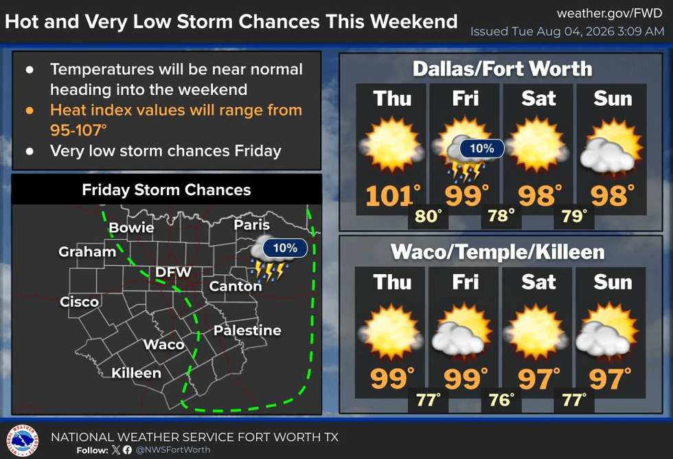
We're waking up to temperatures in the 70s this morning—not quite as cool as the last few mornings. Highs today will climb to around 100°, and afternoon temperatures will remain fairly steady through the weekend, hovering near the century mark.
As humidity continues to rise, so will the heat index. By this weekend, "feels-like" temperatures could approach 105°, putting us right on the threshold for Heat Advisories. We'll keep a close eye on that over the next few days.
Rain chances remain very slim. An upper-level ridge is expected to split, with one center shifting west and another developing to our east. That could create just enough of a weakness in the atmosphere for a slight chance of a shower or thunderstorm late Friday into the weekend. East Texas has the better opportunity for a few late-day showers and storms beginning as early as Thursday, but across North Texas, most of us will stay dry.
Morning lows will generally range from 75° to 80°, so even overnight temperatures will remain quite warm.
Stay cool, stay hydrated, my friends, and enjoy the weather while you can—because it's the only weather you've got!
7-Day Headlines:
- DFW Airport hit 101 degrees on Monday
- Air Quality Alert today
- No Heat Advisories….for now
- Flirting with triple digits through Friday
- VERY Isolated showers and storms on Friday
- Upper 90s this weekend! HA!
- Staying hot next week
- Download our AUDACY app! Listen to KRLD LIVE at home or at work
Almanac:
- Yest Rain: 0.00”; Yest High: 101; Low: 74
- Today’s Averages: High: 97; Low: 77
- Record high: 108 (2011); Record low 63 (1915)
- August rain: 0.00”; Deficit: <0.16”>
- 2026 Rain: 22.61”; Snow: 2.4”; Surplus: 0.08”
- Sunrise: 6:45am; Sunset: 8:23pm
Forecast:
Tuesday: **Air Quality Alert** Mostly sunny and hot. High: 101. Heat index: 103. Wind: South 5-10 mph.
Tuesday night: Clear and warm. Low: Upper 70s. Wind: South 5-10 mph.
Wednesday: Mostly sunny and hot. Isolated late-day showers and storms well east of DFW. High: 102.
Thursday: Partly cloudy, continued hot. High: 101.
Friday: Partly cloudy and hot. Humidity increasing. Isolated late-day showers and storms. High: Near 100.
Weekend: Partly cloudy, hot and humid. High: Upper 90s.
Monday: Partly cloudy, hot and humid. High: Upper 90s.
LISTEN on the Audacy App
Tell your Smart Speaker to "PLAY 1080 KRLD"
Sign Up to receive our KRLD Insider Newsletter for more news
Follow us on Facebook | Twitter | Instagram | YouTube