Good Friday morning, everyone! I hope you’ve had a great work week and are looking forward to the weekend.
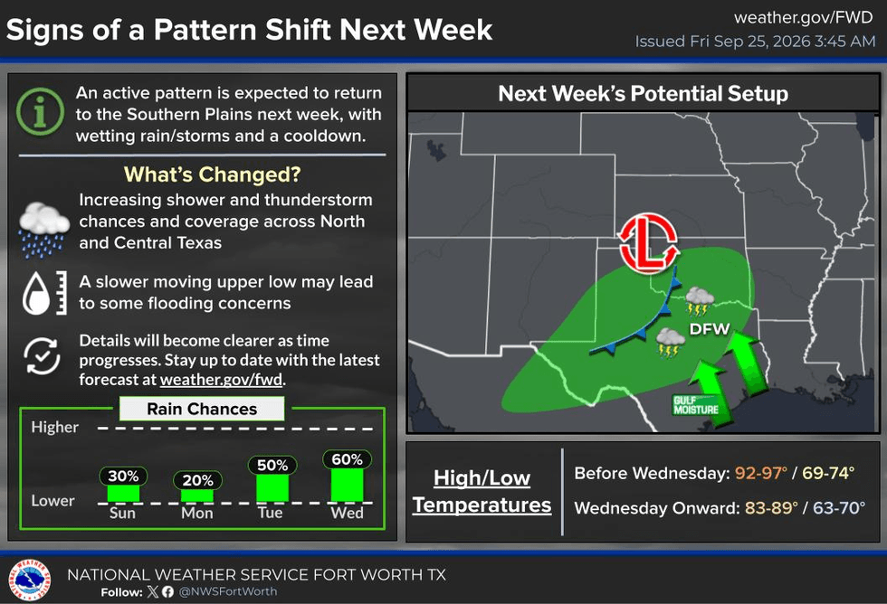
Summer is definitely hanging on across North Texas, and unfortunately, it looks like it will continue through early next week. A pattern change begins to unfold Tuesday into Wednesday, so hang in there. The stronger cold front still looks like it will come through, but unfortunately, the coolest air now appears likely to remain well north of the Lone Star State. We’ll keep a close eye on everything for you through the weekend.
It is a little cooler this morning, so if you haven’t noticed yet, step outside! Yesterday, we only reached 94 degrees. The average high for this time of year is now down into the mid to upper 80s, so we’re still running above average.
For the opening weekend of the State Fair of Texas, temperatures will remain on the warm side. Today, look for highs in the low to mid-90s. Tomorrow, we’ll be in the low to mid-90s, with temperatures potentially reaching the mid to upper 90s by Sunday. We’ll be back into the low to mid-90s Monday, with low 90s expected Tuesday.
There could be a few scattered showers and thunderstorms Sunday afternoon and evening, especially across western counties. It’s a setup similar to what we could see today. However, most of the Dallas-Fort Worth area should remain dry through the weekend, so I wouldn’t cancel those outdoor plans just yet.
If you’re heading to the State Fair, make sure you stay hydrated. My suggestion is to take mass transit if you can. Take the rail and it will drop you right near the front gates, and you won’t have to worry about fighting for parking. High school football games will mainly be in the evening, but if you’re heading to a college game or spending extended time outdoors, start drinking plenty of water the day before. Don’t wait until you’re already thirsty.
We’re also continuing to track Hurricane Polo. It’s currently out over the open Pacific, several hundred miles northwest of Cabo, with maximum sustained winds around 160 mph. That is one powerful hurricane. Polo is moving west at about 12 mph, but a turn toward the north is expected Sunday, followed by a turn toward the northeast Monday.
The system is expected to pass near or across the Baja Peninsula, with some potential for rough surf and dangerous rip currents along portions of the coast. Polo should weaken rapidly as it moves inland across northern Mexico.
The bigger story for us will be the moisture associated with the system. Some of that moisture will work its way into West Texas and the Permian Basin by the middle of next week. Areas across North Texas are dealing with severe to exceptional drought, so any rainfall we can get will certainly be welcome.
As the next front approaches Wednesday, we could see a line of showers and thunderstorms develop along the front. However, because of the expected track of the system and its moisture, the coolest air will once again remain well to the north of the Lone Star State.
We should finally see some improvement in temperatures by the middle to end of next week, with highs dropping into the 80s and lows into the 60s. However, it probably won’t be quite as cool as we were hoping for.
The next front may finally do the trick sometime in early October.
I’m Meteorologist Dan Brounoff. Have a great Friday, enjoy the opening weekend of the State Fair of Texas, stay hydrated, and most importantly, enjoy the weather whenever you can.
It’s the only weather you’ve got!If you want, I can also make this a little more humorous and “Dan the Weatherman” conversational while keeping all the weather information intact.
7-Day Headlines:
- DFW Airport hit 94 degrees on Thursday
- 52 triples this summer
- Above average temperature through next Tuesday
- Hot and mainly dry for the State Fair this weekend
- Pattern change arrives next Tuesday into Thursday
- Increasing rain chances and cooler temperatures
- Download our AUDACY app! Listen to KRLD LIVE at home or at work
Almanac:
- Yest Rain: 0.00”; Yest High: 94; Low: 78
- Today’s Averages: High: 86; Low: 65
- Record high: 102 (2005); Record low 44 (1989)
- September rain: 0.01”; Deficit: <2.23”>
- 2026 Rain: 22.62”; Snow: 2.4”; Deficit: <4.17”>
- Sunrise: 7:19am; Sunset: 7:19pm
Forecast:
Friday: Opening Day of The State Fair of Texas. Partly cloudy and hot. Isolated late-day storms well west of DFW. High: Low to mid 90s.
Weekend: Partly cloudy, continued warm. Isolated showers and storms, mainly west of DFW. Highs: Mid to upper 90s.
Monday: Partly cloudy and warm. High: Low 90s.
Tuesday: Increasing clouds and cooler. Scattered showers and storms late. High: Low 90s.
Wednesday: Cloudy and cooler. Numerous showers and storms. High: Near 80.
Thursday: Mostly cloudy. Scattered showers and storms ending. High: Mid 80s.
LISTEN on the Audacy App
Tell your Smart Speaker to "PLAY 1080 KRLD"
Sign Up to receive our KRLD Insider Newsletter for more news
Follow us on Facebook | Twitter | Instagram | YouTube