


As we reach the first day of September, here are some terrible North Texas summer stats.
Forty-seven triple-digit days this year is tied for the sixth-most all-time, 46 consecutive days with no measurable rain ranks this ninth-most all-time, and the 23 days with high temperatures of 105 degrees or higher is second. August is the second driest and the second hottest, while meteorological summer (June 1 - Aug. 31) ended as the third-hottest ever at 88.7 degrees and No. 4 with the lowest rainfall total of 1.25 inches.
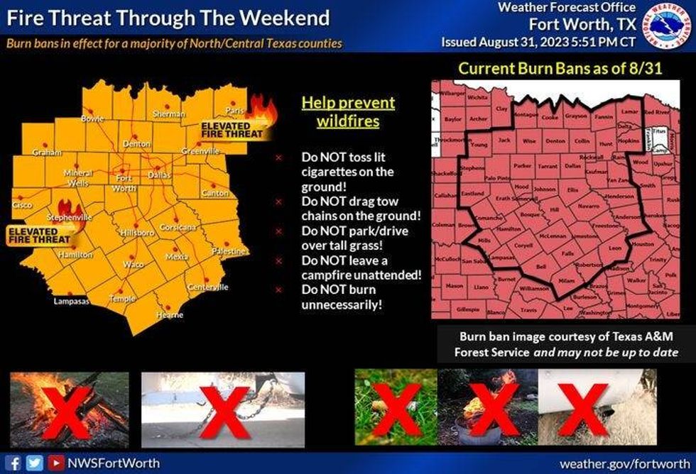 Fire threat for Labor Day weekendNational Weather Service
Now here's more bad news for you: we're going to be flirting with the 100-degree mark over the next seven days across North Texas. Morning lows will be in the 70s. Humidity levels will be tolerable Friday and Saturday, but start to increase Sunday through next week, as a southerly wind picks up and gusts up to 25 miles mph.
Area lakes should be OK as far as the chop goes until Labor Day. If you're going to be enjoying the late summer sun, watch out for a few scattered afternoon and early evening showers and storms on Sunday and Monday, especially along and east of a line that runs from Sherman to McKinney to Dallas to Waxahachie. The showers and storms should stay below the severe threshold and will dissipate by sunset.
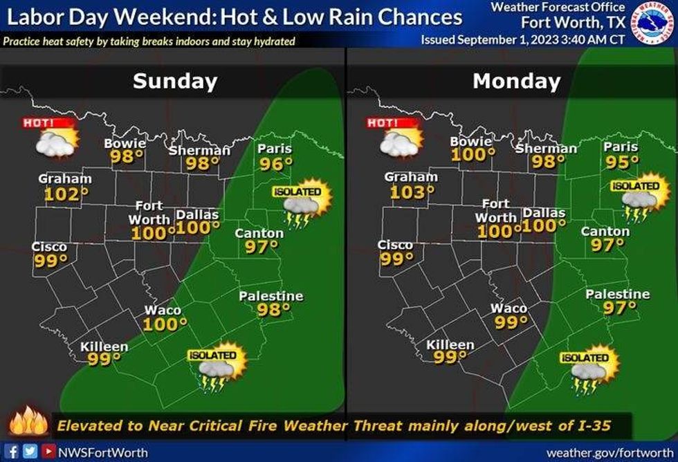 Forecast for Sunday and Monday.National Weather Service
Widespread rain is not in the forecast, nor are cold fronts or relief from the heat anytime soon. Please keep in mind, that this will not be record heat, but temperatures will remain above average (93 and 92) for this time of the year. The air quality will be terrible through Sunday with the Canadian smoke looming overhead.
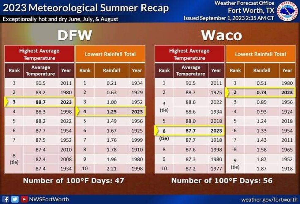 Summer heat and rainfall recapGetty Images
7-Day Headlines:
* DFW reached 99 degrees Thursday.
* No measurable rain since July 16, ranks No. 9 all-time (84 days in 2000).
* 47 triple-digit days in 2023.
* No Excessive Heat Warnings or Advisories Friday.
* Canadian wildfire smoke looms overhead. Poor air quality.
* Flirting with triple digits Labor Day weekend.
* Isolated showers and storms east of DFW Sunday - Tuesday.
* Heat continues next week.
*Thursday rain: 0.00"; Thursday High: 99; Low: 75
*Friday's averages: High: 93; Low: 73
*Record high: 109 (2000): Record low: 59 (1915)
*August rain: Trace; Deficit:
*2023 Rain: 14.83"; Deficit:
*Sunrise: 7:03am; Sunset: 7:52pm
Friday: *Ozone Action Day* Mostly sunny, smokey and hot. Low humidity. Grass fire danger. High: Upper 90s. Wind: SE 5-10 mph.
Friday night: Clear and pleasant. Low: Low to mid 70s. Wind: East 5-10 mph.
Saturday: Mostly sunny, hazy and hot. High: Near 100. Wind: East 5-10 mph.
Sunday: Mostly sunny, hazy and hot. Isolated showers and storms EAST of DFW. High: Near 100.
Labor Day: Mostly sunny and hot. Isolated showers and storms east of DFW. High: Near 100.
Tuesday - Thursday: Mostly sunny, breezy and hot. Increasing humidity High: Near 100.
LISTEN on the Audacy App
Tell your Smart Speaker to "PLAY 1080 KRLD"
Sign Up to receive our KRLD Insider Newsletter for more news


