
Tropical Storm Edouard made landfall yesterday in the southwestern Louisiana coastline with maximum sustained winds of 60 mph. Since then, the storm has tracked through the Port Arthur and Beaumont areas and continues to move slowly toward the northwest at around 8 mph.
Edouard is now a tropical depression, with winds estimated at 35 to 40 mph as of 4:00 this morning. The system should gradually pick up some forward speed today.
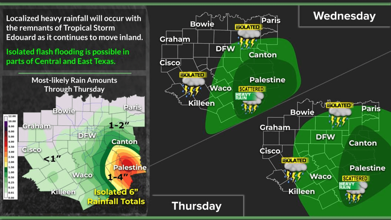
By this evening, the center of circulation should be near the Palestine and Athens areas, southeast of the Dallas-Fort Worth area. The big question is: Will it finally rain at DFW Airport after 48 days without measurable rainfall?
There is a chance.
As we move through the next 24 hours, we could see isolated showers and thunderstorms developing across North Texas, with moisture feeding in from the southeast and wrapping around the northern side of the circulation.
By Thursday morning, the center should be near the Kaufman area, just east of Waxahachie. Some potentially heavy rain could develop, mainly along and south of Interstate 20 and east of Central Expressway. A few showers and storms could also develop farther west, including parts of the Fort Worth area.
We'll have to see exactly how the track evolves over the next 24 to 36 hours, but I do think parts of North Texas will finally get some rain. The best chances will generally be south of Highway 380.
There are currently no flood watches in place, but some locally heavy rainfall will be possible, especially Thursday.
As for temperatures, we could still reach around 100° at DFW Airport today, although increasing clouds should help keep temperatures in the 90s on Thursday. That will be a welcome bit of relief. A leftover shower or thunderstorm will also be possible Friday, with highs in the mid-90s.
Looking ahead to the holiday weekend, the strongest part of the ridge of high pressure should remain north of us. Some locations may still approach 100°, but widespread rain is not expected.
The hot weather will continue into the first part of next week. No major cold fronts are showing up yet, but I guarantee you one will eventually make its way here before the end of September.
Have a great day today. Hopefully, you see some rain in your backyard, and enjoy the weather whenever you can. It's the only weather you've got!
7-Day Headlines:
- DFW Airport hit 100 degrees on Monday
- 38 triples this summer
- 48 days with no measurable rain at DFW
- Watching the remnants of Edouard!
- Southeastern half of north Texas gets rain Thursday
- Cooler Thursday
- Heating back up for Labor Day weekend
- Download our AUDACY app! Listen to KRLD LIVE at home or at work
Almanac:
- Yest Rain: 0.00”; Yest High: 100; Low: 80
- Today’s Averages: High: 92; Low: 73
- Record high: 109 (2000); Record low 58 (1915)
- September rain: 0.00”; Deficit: <0.10”>
- 2026 Rain: 22.61”; Snow: 2.4”; Deficit: <2.04”>
- Sunrise: 7:04am; Sunset: 7:50pm
Forecast:
Wednesday: Partly cloudy, hot with more humidity. Isolated showers moving in from the SE after the noon hour. High: Near 100. Wind: SSE 5-15 mph.
Wednesday night: Partly cloudy, breezy, mild and humid. Showers SE of DFW. Low: Upper 70s. Wind: SSE 10-15 mph.
Thursday: Partly to mostly cloudy and a bit cooler. Higher humidity. Scattered showers and isolated thunderstorms. Heaviest rain south and east of Dallas. High: Near 90. Wind: SE 10-20.
Friday: Partly cloudy, hot and humid. An isolated afternoon storm. High: Mid 90s.
Saturday and Sunday: Mostly sunny and humid. Heating back up. Highs: Upper 90s Heat index: Near 105.
Labor Day: Mostly sunny and hot. High: Near 101.
Tuesday: Mostly sunny, continued hot. High: Near 100.
LISTEN on the Audacy App
Tell your Smart Speaker to "PLAY 1080 KRLD"
Sign Up to receive our KRLD Insider Newsletter for more news
Follow us on Facebook | Twitter | Instagram | YouTube