We're waking up the temperatures a little cool for this time of the year with readings in the low to mid forties. Skies are mainly clear, but clouds will rapidly increase this evening as a strong upper level disturbance rolls in from the southwest.
There will be a few scattered showers and maybe even a rumble of thunder, especially along and south of I-30. Morning lows will dip back into the forties by daybreak..
Another reinforcing shot of cooler air arrives early Tuesday morning. This will keep temperatures in the low to mid 60s for highs on Tuesday. Factor in the 30 mph wind gusts, and it'll feel like it's in the 50s all day long. Jackes will definitely be necessary though the day.
Wednesday looks spectacular with highs in the upper 60s, with a light wind.
 National Weather Service - Fort Worth
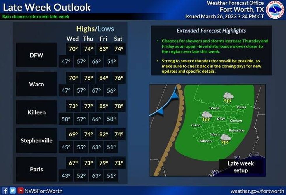
South winds pick up on Thursday and Friday and temperatures warm up a bit. Highs on Thursday will reach the low seventies with a few showers and storms arriving from the west by late evening and overnight. I think the best chances for showers and strong thunderstorms will be on Friday, as another cold front comes into the area. Temperatures will warm into the low 80s.
Another cold front comes through the 2nd half and Friday clearing things out and cooling temperatures back into the low to mid seventies into the weekend. Yes, it will be another spectacular weekend.
*Yest Rain: 0.00"; Yest High: 77 Low: 50
*Today's Averages: High: 72; Low: 51
*Record high: 96 (1956); Record low: 23 (1925)
*March Rain: 2.72"; Deficit: 0.07"
*2023 Rain: 8.02"; Deficit: 0.01"
*Sunrise: 7:22am; Sunset: 7:45pm
Today: Increasing clouds and cooler. High: Mid 60s. Wind: ENE 10-20 mph.
Tonight: Cloudy and cool. Chance of showers, mainly south of I-20. Low: Mid to upper 40s. Wind: North 10-15 mph.
Tomorrow: Morning clouds, afternoon sun. Another cold front early. Windy and chilly. High: Low to mid 60s. Wind: North 15-25 mph.
Wednesday: Mostly sunny and cool. Less wind. High: Upper 60s.
Thursday: Partly to mostly cloudy and seasonable. Scattered showers and storms late. High: Low to mid 70s.
Friday: Scattered showers and storms. A few strong ones possible. High: Low 80s.
Weekend: Ample sunshine and pleasant. Highs: Low to mid 70s.
LISTEN on the Audacy App
Tell your Smart Speaker to "PLAY 1080 KRLD"
Sign Up to receive our KRLD Insider Newsletter for more news