
GOOD MORNING, NORTH TEXAS! QUIET WEATHER HERE, BUT A MAJOR HURRICANE IS HEADING TOWARD THE GULF COAST!
Good morning, my friends! Happy Friday! I hope everyone has had a great week!
**NORTH TEXAS WEATHER: ENJOY IT WHILE IT LASTS!**
Our weather will remain quiet across North Texas today, throughout the weekend, and for most of next week as a strong ridge of high pressure continues to dominate our weather pattern.
We'll enjoy cool mornings, mild temperatures early in the day, and very warm afternoons for this time of year. By early next week, temperatures could climb to around 10 degrees above average. In other words, it's going to feel more like summer than fall!
**HURRICANE ISAIAS: A DANGEROUS SITUATION ALONG THE GULF COAST!**
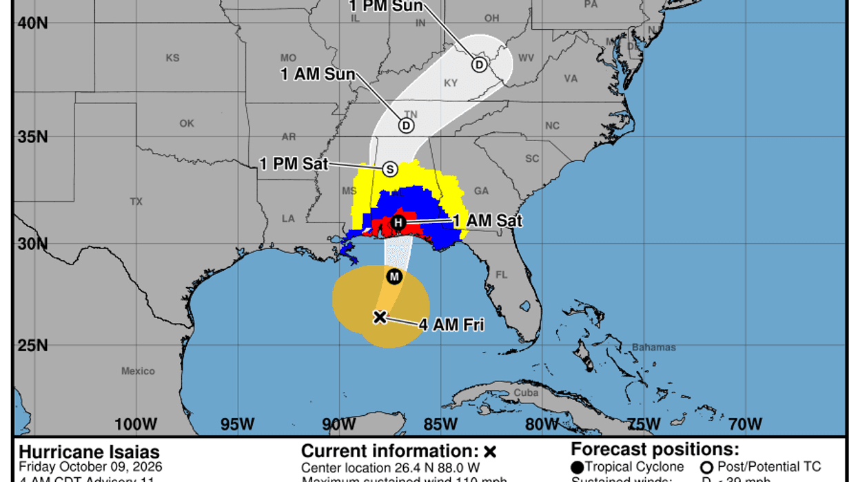
Meanwhile, if you haven't heard, Hurricane Isaias continues to strengthen over the Gulf of Mexico. As of 4 a.m. Friday, the storm was located about 200 miles south of the mouth of the Mississippi River, with maximum sustained winds of 110 mph.
That's just 1 mph below Category 3 status, which marks the beginning of major hurricane strength. Additional strengthening is possible before landfall later today, although some forecast guidance suggests the storm could weaken slightly as it approaches the coast.
**HERE'S WHAT RESIDENTS ALONG THE GULF COAST NEED TO KNOW:**
**Storm Surge:** A potentially life-threatening storm surge of 4–8 feet is possible along and east of the storm's center, creating dangerous coastal flooding.
**Heavy Rainfall:** Widespread rainfall totals of 5–10 inches are possible in some areas, raising the threat of significant inland flooding.
**Dangerous Rip Currents:** Life-threatening surf and rip currents could affect beaches well beyond the immediate landfall area.
**Tornado Threat:** Tornadoes will also be possible, particularly east of the storm's center, including portions of eastern Alabama and western Georgia.
Folks, this is a storm that needs to be taken seriously. If you have family or friends along the Gulf Coast, please check on them and make sure they're following instructions from local emergency management officials. If evacuation orders have been issued, don't wait until the last minute to leave!
Please keep everyone in the path of this storm in your thoughts and prayers.
As the system moves inland, its rain and wind impacts will spread across the Southeast and into the Tennessee Valley and Mid-Atlantic through the weekend. The storm is expected to continue northeastward toward the northeastern United States by early next week.
**A BIG WEATHER CHANGE COULD BE COMING TO NORTH TEXAS!**
Here's something I'm watching closely. Hurricane Isaias could help alter the upper-level wind pattern across the country by the middle to latter part of next week.
That could finally open the door for a decent cold front to move through North Texas, bringing us a chance of showers and thunderstorms late Thursday into Friday.
And here's the part I really like: Much cooler weather could arrive by NEXT weekend, just in time for the final weekend of the State Fair of Texas!
High temperatures potentially in the 60s next Saturday? Now THAT sounds like State Fair weather to me!
Of course, we're still several days away, so we'll need to watch how the forecast develops. I'll keep you updated as we get closer.
**FOR NOW, ENJOY OUR QUIET NORTH TEXAS WEATHER WHILE YOU CAN!**
We've certainly had our share of extreme heat, drought, and flooding this year. For now, we'll enjoy a few more warm, dry days before we potentially get a taste of some much-needed fall weather.
Please LIKE and SHARE this post to help keep your family and friends weather aware, especially anyone living along the Gulf Coast!
Remember, folks, it's the only weather you've got!
— Dan the Weatherman
7-Day Headlines:
- DFW Airport hit 90 degrees on Thursday
- Isaias closing in on major hurricane status
- Landfall along the FL/AL border late tonight
- No impacts from Isaias in North Texas
- Pleasant mornings/warm afternoons through most of next week
- Great weekend to hit the State Fair of Texas
- BIG change coming NEXT Friday
- Download our AUDACY app! Listen to KRLD LIVE at home or at work
Almanac:
- Yest Rain: 0.00”; Yest High: 90; Low: 647
- Today’s Averages: High: 81; Low: 60
- Record high: 96 (2017); Record low 36 (1917)
- October rain: 3.84” ”; Surplus: 2.97”
- 2026 Rain: 26.62”; Snow: 2.4”; Deficit: <1.52”>
- Sunrise: 7:29am; Sunset: 7:01pm
Forecast:
Friday: *Air Quality Alert* Sunny and warm. High: Near 90. Wind: East 5 mph.
Friday night: Clear and mild. Low: Mid 60s. Wind: East 5 mph.
Saturday: *Air Quality Alert* Sunny and warm. High: Near 90. Wind: East 5 mph.
Sunday: Sunny, breezy, continued warm. High: Near 90.
Monday - Wednesday: More of the same. Mostly sunny, breezy, and warm. Highs: Near 90.
Thursday: Increasing clouds, warm and breezy. Scattered storms late. High: Upper 80s.
LISTEN on the Audacy App
Tell your Smart Speaker to "PLAY 1080 KRLD"
Sign Up to receive our KRLD Insider Newsletter for more news
Follow us on Facebook | Twitter | Instagram | YouTube