Tolerable temperatures today, the Siberian Express arrives Thursday morning, bitter cold air through Christmas morning, a few flurries tomorrow, and a rapid warm up next week. Those are your weather stories over the next 7 days.
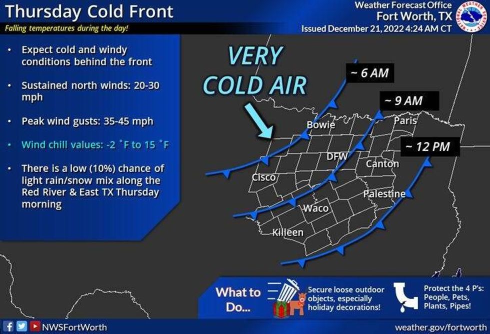
We're waking up to temperatures between 26 and 34 degrees this morning with some passing high clouds. A mix of sun and clouds today with high temperatures near 50 degrees. Wind will be light from the south.. tonight, clouds will increase out the head of the Siberian Express.. This very strong cold front will plow through the area by mid-morning tomorrow. We'll be in the low 40s at around 9:00 a.m., near 20 by noon, upper teens by 6:00 p.m. and down anywhere between 8 and 12 degrees by Friday morning. There's also a very slight chance of a few snow flurries late tomorrow morning through mid afternoon, but no accumulations are expected.
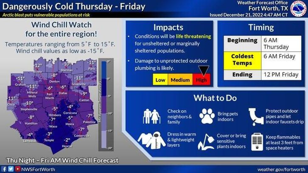
Yes the air will be cold, but when you factor in the 40 to 45 mph wind gusts during the day tomorrow, wind chill readings will approach zero, therefore a wind chill watch is in effect for tomorrow afternoon through the overnight. Please make sure you winterize your home, vehicles and make sure your pets stay warm and any friends or relatives you know that may not have heat, give them a warm place to stay.
 National Weather Service - Fort Worth
It'll stay cold Friday and Saturday. Highs on Friday will only warm into the low to mid 20s, with a northerly wind gusting to 25 mph. The wind relaxes Friday night, but temperatures will remain cold on Saturday morning with readings falling into the upper teens. Temperatures will struggle to reach the freezing mark by afternoon..
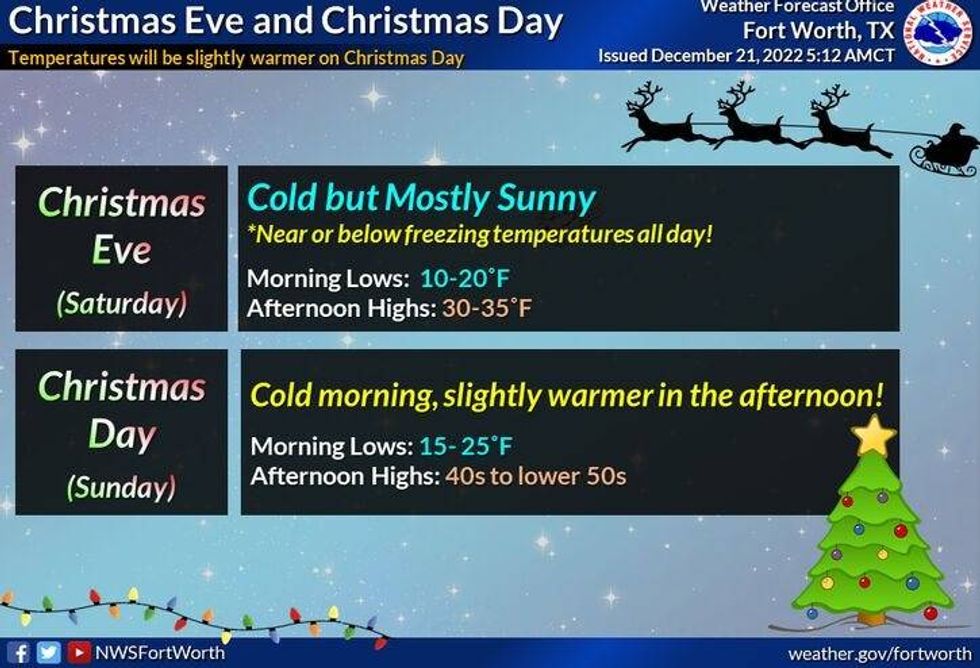
Christmas day will start off cold with low temperatures in the twenties but afternoon highs will warm to near 40°. Our warm up continues in the early next week with highs back in the fifties Monday and Tuesday.
 National Weather Service - Fort Worth
This event will be a huge shock to the body and to your pipes, but good news is, it won't last nearly as long as the winter blitz of 2021. Stay warm my friends!
Oh, and please remember to enjoy the weather when you can, it's the only weather you've got!
7-Day Headlines:
* DFW reached 56 degrees yesterday... trace of rain.
* Last relatively mild day.
* The Siberian Express arrives mid-morning tomorrow.
* A few flurries late morning through the afternoon.
* 40s early, mid 20s by noon, teens by PM commute.
* Single digit wind chills, Wind Chill Watch through Friday morning.
* Below freezing through noon on Christmas.
*Yest Rain: 0.00"; High: 56; Low: 39
*Today's Averages: High: 57; Low: 37
*Record high: 85 (2010); Record low: 10 (1983)
*December rain: 2.38"; Surplus: 0.56"
*2022 Rain: 36.68"; 2022 Surplus: 0.64"
*Sunrise: 7:27am; Sunset: 5:26pm
 National Weather Service - Fort Worth
Looking Ahead:
Today: Partly cloudy and cool. High: Near 50. Wind: South 5-10 mph.
Tonight: Increasing clouds and chilly. Low: Near 40. Wind: South 5-10 mph.
Tomorrow: Mid-morning Arctic front. Very windy and sharply colder. TEMPS: 9am 41; Noon: 24; 6pm: 18; 10pm: 15. A few snow flurries 10am-3pm. Wind: NNW 25-35, G45 mph.
Friday: Sunny, windy and cold. Low: 8-12; High: Low to mid 20s. Wind: 15-25mph.
Saturday: Morning clouds, afternoon sun. Low: Upper teens. High: Near freezing.
Christmas: Sunny and cool. High: Low 40s.
Sunday and Monday: Sunny and warmer. Highs: 50s
LISTEN on the Audacy App
Tell your Smart Speaker to "PLAY 1080 KRLD"
Sign Up and Follow NewsRadio 1080 KRLD