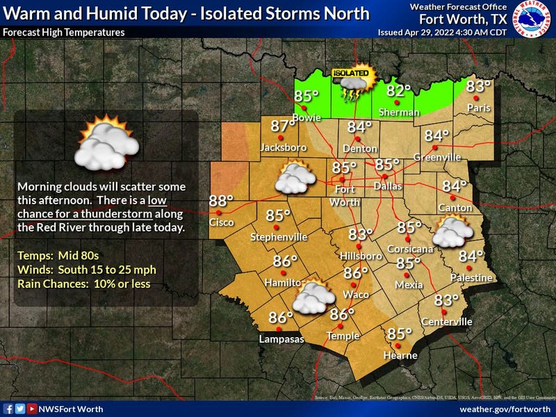

We're waking up to temperatures near 70゚, extensive cloud cover, a lot of wind, and muggy air! Nothing is showing up on radar and I'm not expecting anything until late tonight and early tomorrow morning across north Texas. Sunshine will peak out later this morning through the afternoon with highs in the mid eighties. South winds will gust as high as 35MPH.
Tonight, a large area severe storms will break out across the central plain states and extend southward into Oklahoma. A few of these storms may cross the Red River a little after midnight. As we approach daybreak tomorrow, a cold front will sag in the area. A few of these storms may survive as they move into DFW. Nothing severe is expected and coverage will not be widespread.
This weak cold front will sag south of the Metroplex tomorrow. We'll see a partly cloudy sky here with highs in the low eighties. A north wind 10 to 20MPH.
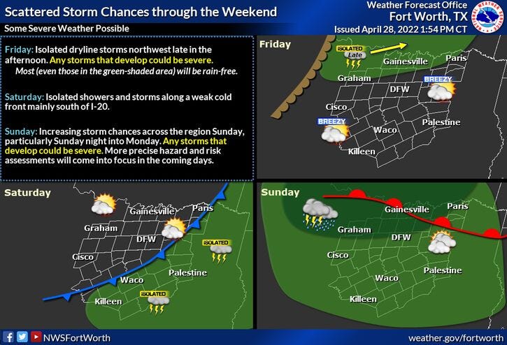
By tomorrow evening, a few storms will form along this front south of the area, but as this front lifts north overnight into Sunday morning, a few of these storms could sneak back into the area. Nothing too severe is expected.
This front will lift back in Oklahoma on Sunday, A south wind willl return with highs in the mid eighties. Then all eyes shift to the west of us late Sunday and early Monday morning.
A large area of showers and storms, some severe, will break out in west Texas Sunday late afternoon and evening. These storms will head east-northeast Sunday night into Monday morning. Latest data suggests most of the rain will be up in Oklahoma, but I can't rule out some storms drifting into the area before daybreak Monday. Isolated severe is possible with with hail and wind being the primary threats. Not everyone will see rain early Monday morning.
Monday afternoon looks OK with a partly cloudy sky and highs in the mid eighties.
On Tuesday, Wednesday and Thursday, scattered showers and storms are back in the forecast. It's still way too early to pinpoint the timing, placement, and severity of these storms. A cold front will be lingering in the area all 3 days. Stay tuned!
*Yest Rain: 0.00”; *Yest High: 82; Low: 62
*Today’s Averages: High: 79; Low: 59
*Record high: 97 (1909); Record low: 41 (1908)
* April rain: 2.54”; April deficit: 0.42"
*2022 rain: 6.77”; 2022 deficit 4.78"
*Sunrise: 6:43am; Sunset: 8:09pm
Today: Morning clouds, afternoon sun. Windy and warm. High: Low to mid 80s. Wind: South 15-25, G35 mph.
Tonight: Increasing clouds, windy and humid. Low: Near 70. Wind: South 15-25, G30 mph.
Tomorrow: Morning scattered showers and storms, afternoon sun. Late afternoon and evening scattered storms south of DFW. High: Low 80s. Wind: North 10-20 mph.
Sunday: Morning scattered showers and storms, afternoon sun. Chance of showers and storms by late evening. Some severe. High: Mid 80s.
Monday: Early morning storms, then partly cloudy and warm. High: Mid 80s.
Tuesday: Mostly sunny, warm and humid. Scattered showers and storms late. High: Mid 80s.
Wednesday and Thursday: Partly cloudy. Scattered showers and storms. High: Mid 80s.
Related

LISTEN on the Audacy App
Sign Up and Follow NewsRadio 1080 KRLD