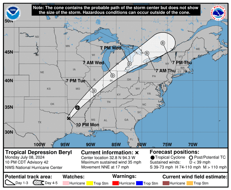
Big bad Beryl barreled into the middle Texas coast Monday morning and is now barreling through Arkansas, taking all of the inclement weather with it. 5" to 8" fell in east Texas, 8" to 12" of rain across SE Texas.
Power outages and deaths are reported across the state. Crews are working feverishly to get power restored. Unfortunately, Beryl didn't bring a lot of rain to north Texas, with only 0.09" of rain measured at DFW airport. Some of you saw a little bit more, others not a drop.
In the wake of Beryl, surface winds are from the north Tuesday morning. This has ushered in slightly drier air into north Texas, allowing temperatures to fall to near 70°. It feels quite nice out. Yesterday we only hit 86°. Today, we'll reach the low 90s with relatively dry air still in place.
 NWS
NWS
Tomorrow Wednesday looks to be a few degrees warmer with a slight chance of an afternoon or evening storm. Most stay dry.
The hottest temperatures through the week and into the weekend will be into the western United States, building into the central plains states. We'll be on the southern periphery of the upper level high so temperatures won't be too bad, but still slightly above average. Afternoon highs will reach the mid to upper 90s. Afternoon humidity levels will still be tolerable with heat index values slightly above 100°. Also, I can't rule out a few late-day showers of storms this weekend.
No changes are in the forecast through early next week.
______________________________
7-Day Headlines:
* DFW Airport reached 86 yesterday. 0.09" of rain fell at DFW Airport.
* The remnants of Beryl are in Arkansas now.
* Heating up this week into the weekend.
* Isolated late afternoon showers and storms tomorrow.
* Possible Heat Advisories by Friday.
* Isolated late afternoon showers and storms this weekend.
__________________________________________________________
*Yest Rain: 0.09"; Yest High: 86; Low: 74
*Today's Averages: High: 95; Low: 75
*Record high: 106 (1980); Record low: 61 (1905)
__________________________________________________________
*July Rain: 0.56"; Deficit:
*2024 Rain: 29.30"; Surplus: 8.23"
*Sunrise: 6:28am; Sunset: 8:39pm
__________________________________________________________
Today: Goodbye Beryl, hello sunshine. High: Low 90s. Wind: NW 10 mph.
Tonight: Clear and comfortable. Low: Low to mid 70s. Wind: Lt. Var.
Tomorrow: Partly cloudy and warm. Isolated late day showers and storms. High: Mid 90s. Wind: NE 5-10 mph.
Thursday and Friday: Mostly sunny and warm. High: Mid 90s.
Weekend: Mostly sunny and hot. A few late day showers and storms. Highs: Mid to upper 90s.
Monday: Mostly sunny and hot. High: Mid to upper 90s.
LISTEN on the Audacy App
Tell your Smart Speaker to "PLAY 1080 KRLD"
Sign Up to receive our KRLD Insider Newsletter for more news
Follow us on Facebook | Twitter | Instagram | YouTube