
Well, some lucky folks saw some rain yesterday afternoon and evening — and some of it was HEAVY! Meanwhile, others didn't measure a drop, just like DFW Airport!
Good morning, everyone, and welcome back to Monday! Fall officially starts tomorrow, but it's definitely NOT going to feel like fall just yet!
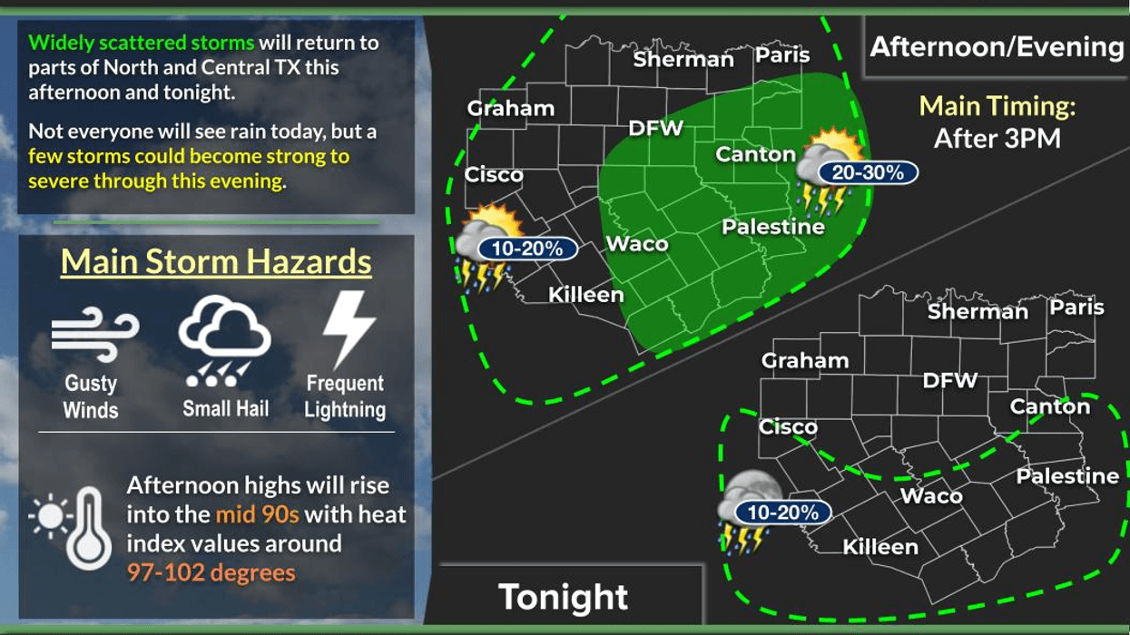
There will still be plenty of rain showing up on the radar today and tomorrow across parts of North Texas. We could see some strong storms, with perhaps one or two becoming severe with gusty winds and small hail.
I'll be tracking a slow-moving cold front today. It's not a particularly strong front, but it will slowly move through the area and become a focal point for showers and thunderstorms to regenerate across North Texas.
These storms will be slow movers, so if one happens to train over your backyard, you could easily pick up an inch or two of rain!
Temperatures today will still reach the mid-90s across the area, with heat index values around or slightly above 100°. No Heat Advisories are in place.
The front will linger around the area tomorrow, so we can't rule out a few more showers and storms regenerating during the afternoon and evening.
The bulk of the heaviest rain, however, will be farther west — especially across West Texas, the Panhandle and South Plains, where they REALLY need the rain. If you're traveling that direction Wednesday through Friday, be prepared for some potentially wet weather!
We'll start drying out again Wednesday, Thursday and Friday, with afternoon highs mainly in the low to possibly mid-90s. This weekend looks pretty much like mid-90s as high pressure builds back across the area.
So, even though fall officially starts Tuesday, it isn't going to feel like it anytime soon!
Some of the extended-range data is showing another front potentially coming through next week — which would be right on time. By late September and early October, we typically start seeing our first significant cool-downs, with highs potentially returning to the low to mid-80s and morning lows in the 60s.
In the meantime, I'll keep an eye on things for you. Stay weather aware, get indoors if storms approach, and I hope YOU see some rain today!
I'm Meteorologist Dan Bruno in the KRLD Weather Center.
Enjoy the weather when you can — it's the only weather you've got!
7-Day Headlines:
- DFW Airport hit 96 degrees on Thursday
- 52 triples this summer
- 67 days with no measurable rain at DFW
- Heat Advisories gone
- More rain chances today; weak cold front
- Slightly cooler this week, temps remaining above average
- Fall starts Tuesday
- Download our AUDACY app! Listen to KRLD LIVE at home or at work
Almanac:
- Yest Rain: 0.00”; Yest High: 96; Low: 79
- Today’s Averages: High: 87; Low: 67
- Record high: 99 (1956, 2005); Record low 45 (1983)
- September rain: 0.00”; Deficit: <1.92”>
- 2026 Rain: 22.61”; Snow: 2.4”; Deficit: <3.86”>
- Sunrise: 7:16am; Sunset: 7:25pm
Forecast:
Monday: Partly cloudy and hot.Scattered afternoon and evening showers and storms. High: Mid 90s. Wind: Shifting NE 5-10 mph.
Monday night: A few evening showers, then partly cloudy and slightly cooler. Low: Low to mid 70s. Wind: NE 5-10 mph.
Tuesday: Partly cloudy, slightly cooler. Isolated afternoon and evening showers and storms. High: Low 90s. Wind: NE 10-20 mph.
Wednesday: Partly cloudy and warm. High: Low 90s.
Thursday: Partly cloudy and hot. High: Mid 90s.
Friday: Opening Day of The State Fair of Texas. Partly cloudy and hot. High: Mid 90s.
Weekend: Partly cloudy, continued hot. Slight rain chance on Sunday. Highs: Mid 90s.
LISTEN on the Audacy App
Tell your Smart Speaker to "PLAY 1080 KRLD"
Sign Up to receive our KRLD Insider Newsletter for more news
Follow us on Facebook | Twitter | Instagram | YouTube