A significant amount of heavy rain occurred during the morning hours today, with additional heavy rain expected this evening, overnight, and again on Saturday afternoon and evening.
A flood watch is in effect for all of North Texas, commencing this evening and continuing through at least tomorrow afternoon.
Many individuals were awoken earlier than desired due to thunder, but fortunately, none of the storms were severe. The good news is that the rain is needed. The bulk of the heaviest rain is currently moving out of North Texas. A break in the rain is anticipated late morning through most of the afternoon, with occasional sunshine. Afternoon highs will reach the mid to upper 70s, accompanied by a south wind gusting up to 30 mph, making it a breezy day.
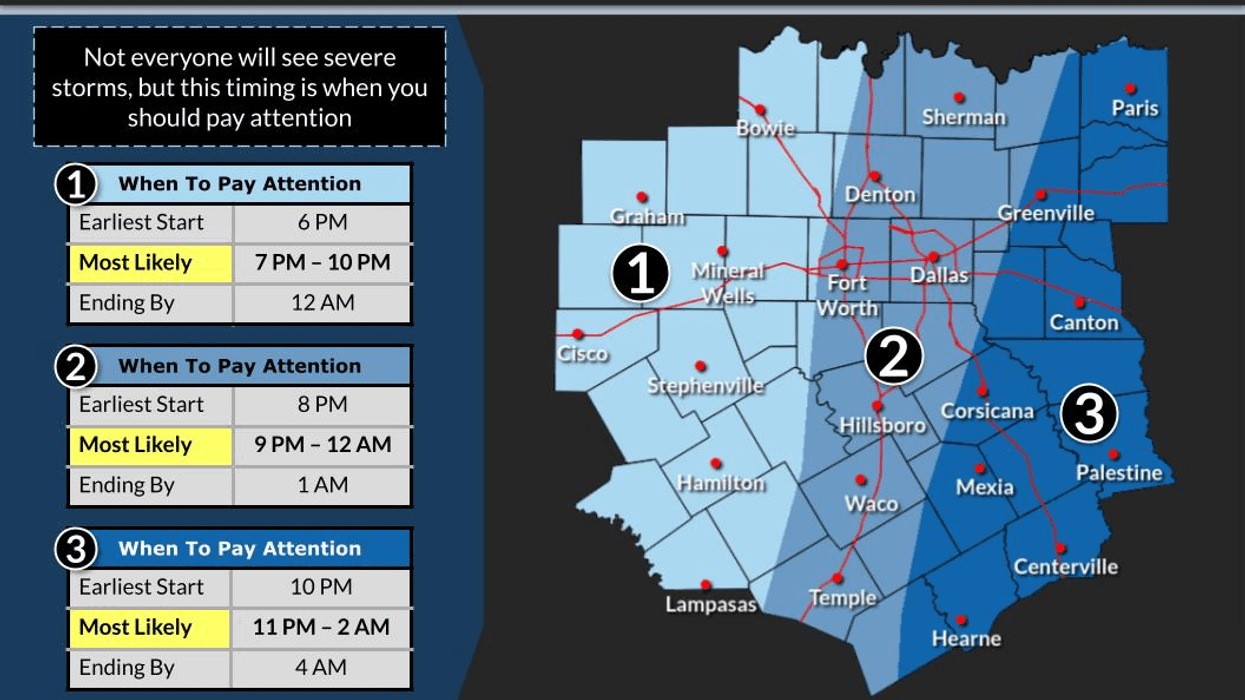
While I cannot rule out the possibility of a few strong storms entering from the south later this afternoon, the likelihood is low. A flood watch will go into effect at 7:00 p.m. this evening and continue until at least 1:00 p.m. tomorrow afternoon. These flood watches may be extended for residents south of Interstate 20 through tomorrow evening.
A large area of strong to isolated severe storms is expected to develop west of us late this afternoon, moving into the area after 7:00 p.m. Most of the rain will fall after bedtime and end from west to east before daybreak. An additional 1 to 3 inches of rain is possible on top of what was observed this morning, hence the flood watch.
A break in the rain is expected tomorrow morning through early afternoon. As the main upper-level system moves across South Central Oklahoma tomorrow, another area of heavy rain with isolated severe storms is possible just south and east of the Dallas-Fort Worth area. Widespread heavy rain will impact Central, East and Southeast Texas, with some storms becoming severe. Areas along and north of Interstate 20 may experience some rain, but the heaviest rain will remain south and east of us. This is the current forecast, but things may change as the storm system drifts farther north, including much of North Texas. Stay tuned for updates.
Conditions will improve on Sunday, with morning clouds and fog burning off, followed by sunshine in the afternoon. Afternoon highs will reach the mid-70s, making it a delightful day.
By late Monday, the first of two cold fronts will arrive. I still expect temperatures to rise into the mid to upper 70s, with no rain along the first front as it moves into the area. A second, stronger front will move into the area on Tuesday, with temperatures again reaching the mid-70s. We will start to feel the cooler air on Wednesday and Thursday, with afternoon highs in the mid-60s and many areas dipping into the 40s in the morning hours. A slow warm-up will occur after that.
Please stay weather-aware this evening for the hail, damaging wind threat, and flash flooding. Continue to monitor my page and NewsRadio 1080 KRLD AM for up-to-the-minute weather information today and tomorrow.
Try to have a good day today and enjoy the weather when you can, it's the only weather you've got!
7-Day Headlines:
* DFW Airport reached 84 on Thursday. 1.25" of rain fell overnight.
* Morning storms moving out.
* Scattered strong to severe storms this afternoon through the overnight.
* Threasts: Moderate hail, damaging wind, an isolated tornado.
* Flood Watch 7pm Friday - 1pm Saturday.
* 2" to 3: of additional rain on the way.
* MUCH cooler next week, starting Tuesday.
_________________________________________________________
*Yest Rain: 0.00"; Yest High: 85 Low: 60
*Today's Averages: High: 75; Low: 54
*Record high: 90 (2003); Record low: 34 (1917)
__________________________________________________________
*October Rain: 0.24"; Deficit:
*2025 Rain: 28.40"; Deficit:
*Sunrise: 7:40am; Sunset: 6:43pm
__________________________________________________________
Friday: Mostly cloudy and mild. Morning rain moving out. Scattered afternoon showers and storms. High: Mid to upper 70s. Wind: SSE 10-20, G30 mph.
Friday night: **Flood Watch** Widespread heavy rain; Isolated severe storms. Threats: Quarter hail, damaging wind, isolated tornadoes, 2" to 3" of rain. Low: Low to mid 60s. Wind: SSE 10-20 mph.
Saturday: Early morning rain, then more showers and storms after the noon hour. Threats: Lightning and heavy rain (0.50" to 2.00"). High: Low to mid 70s. Wind: SSE 10-15 mph.
Sunday: Morning clouds with area of fog. Mostly sunny by late morning. High: Mid 70s.
Monday: Mostly sunny and nice. Weak cold front late. High: Mid to upper 70s.
Tuesday: Mostly sunny, breezy, and comfy. 2nd DRY cold front arrives late. High: Low 70s.
Wednesday and Thursday: Sunny, windy and even cooler! Highs: Mid 60s..LISTEN on the Audacy App
Tell your Smart Speaker to "PLAY 1080 KRLD"
Sign Up to receive our KRLD Insider Newsletter for more news
Follow us on Facebook | Twitter | Instagram | YouTube