
A heightened storm threat is anticipated late into the weekend and extending into next week, with some storms expected to become severe and accompanied by locally heavy rainfall.
Currently, it's Friday and the radar is quiet, with all thunderstorm activity concentrated towards Childress and across Central and Northeast Oklahoma. These storms will not impact DFW.
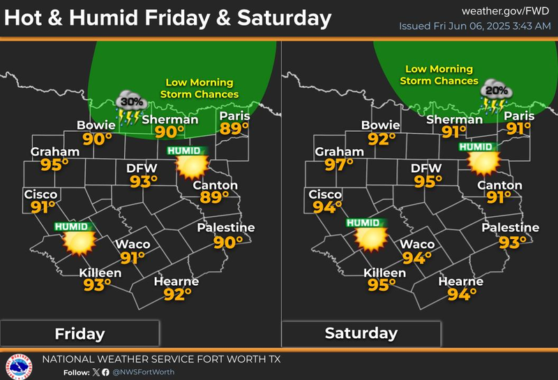
The region is waking up to a bank of clouds and very warm temperatures for this time of year, with DFW Airport recording 80°F at the 5:00 hour. Today's forecast includes sunny, warm, and humid conditions, with afternoon highs reaching the low 90s. Additional storms are expected to form in West Texas and the Panhandle late this afternoon, potentially surviving and moving through Dallas and Fort Worth in a weakened state shortly after midnight tonight. The threat of severe weather is currently not a major concern. Morning lows will dip into the upper 70s.
Saturday will be partly cloudy, hot, and humid, with afternoon highs reaching the mid-90s and heat index values around 103°F. More storms will develop in our Northwest late Saturday evening and may impact Northern counties on Sunday morning. While most of Sunday is expected to be okay, hot and humid conditions will persist, with afternoon highs in the low to mid-90s and heat index values around 103°F.
A significant change in the weather is anticipated Sunday evening, as a complex of storms forms in the high plains of the Panhandle, Western Oklahoma, and Western Kansas. These storms will move towards the region, potentially becoming severe towards midnight, with hail and wind being the primary threats, as well as locally heavy rainfall and flooding on Monday morning.
The storms will calm down by Monday afternoon, but more storms will form along a stationary frontal boundary draped over North Texas by evening, with hail and wind being the primary threats. Afternoon highs will only reach the low 80s. By Monday evening, more storms will form across North Texas, potentially becoming severe.
On Tuesday, the stationary front will lead to more showers than storms, with some potentially becoming severe, and hail and wind being the primary threats.
Days 6 and 7 of the 7-day forecast, Wednesday and Thursday, will include more showers and thunderstorms, with the greatest chance for heavy rain and severe weather anticipated south of the Dallas-Fort Worth area, into the Hill Country and Central Texas. A flooding threat may set up in these areas, with afternoon highs only reaching the low 80s each day.
The position of the stationary front next week will determine where the heaviest rain will fall. In the meantime, the weather will be closely monitored over the weekend, and it is hoped that everyone has a terrific weekend!
7-Day Headlines:
DFW hit 90 degrees on Thursday.
Warm and humid through the weekend.
A few storms Saturday and Sunday morning. Nothing severe.
Increasing storm chances late Sunday into Monday morning.
More scattered storms through Thursday, some severe.
Threats: Hail, damaging wind, flooding.
Flood Watches possible next week.
*Yest Rain: 0.01”; Yest High: 90 Low: 72
*Today’s Averages: High: 90; Low: 71
*Record high: 101 (1948, 1978): Record low: 55 (1970)
*June Rain: 0.33”; Deficit:
*2025 Rain: 18.77”; Surplus: 1.51”
*Sunrise: 6:19am; Sunset: 8:35pm
Friday: Morning clouds, some afternoon sun. High: Low 90s. Heat index near 102 degrees. Wind: South 10-15 mph.
Friday night: Increasing clouds and muggy. Low: Mid to upper 70s. Wind: South 10-15 mph.
Saturday: Decaying morning showers and storms, becoming partly cloudy, hot and humid. High: Mid 90s. Heat index near 103 degrees. Wind: South 10-15 mph.
Sunday: Scattered morning showers and storms, especially north and northeast of DFW. High: Mid 90s.
Monday and Tuesday: Showers and storms, some severe. Flooding threat. Highs: Low 80s.
Wednesday and Thursday: Showers and storms, some severe with heavy rain. Highest coverage south of DFW. Highs: Low to mid 80s.
LISTEN on the Audacy App
Tell your Smart Speaker to "PLAY 1080 KRLD"
Sign Up to receive our KRLD Insider Newsletter for more news
Follow us on Facebook | Twitter | Instagram | YouTube