Scattered strong storms this morning, a few more scattered storms this afternoon, a few more Saturday morning, and the potential for some severe storms Sunday evening on Mother’s Day. Did I mention there are storms in the forecast? 
Good morning, my friends, and happy Friday! Thank goodness it’s Friday.
We’re waking up to plenty of thunder, lightning and pea-sized hail across Collin and Denton counties this morning. Allow extra time getting to work and school in these areas. Temperatures have settled near 60° and will likely stay there until late morning before we see some sunshine develop across the area. There will be a few more scattered storms this afternoon with highs near 80°. Nothing severe is expected at this time.
A cold front will move through Oklahoma late this afternoon and evening, bringing a line of showers and storms across the Red River close to midnight. Current data shows these storms weakening before reaching DFW, but I have a feeling they may hold together. Severe weather chances look low. Temperatures will settle into the mid-60s to start your Saturday.
This cold front will remain north of the Dallas-Fort Worth area, keeping us in the warm and humid sector all day Saturday. Disturbances will stay mainly east and west of us, so I’m not expecting much rain, if any at all, on Saturday. It will be very warm, with afternoon highs in the upper 80s.
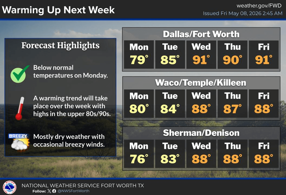
Most of Mother’s Day looks okay. Afternoon highs will be very warm, and some areas could exceed 90° as a cold front approaches late in the day. Numerous showers and storms are expected to develop and move across the area Sunday evening. Large hail and damaging winds appear to be the main threats right now. Everything should move south of DFW by midnight.A comfortably cool Monday is expected, with morning lows in the 50s and afternoon highs in the mid-70s.
A warming trend will begin Tuesday through Thursday, with low 80s Tuesday, upper 80s Wednesday, and near 90° Thursday under plenty of sunshine.
I’ll be keeping an eye on things over the next 48 hours. Keep it tuned to KRLD and my Facebook page for updates as conditions warrant.
Have a great Mother’s Day weekend, and enjoy the weather when you can—it’s the only weather you’ve got.
7-Day Headlines:
- DFW Airport hit 75 degrees on Wednesday.
- Morning scattered storms; afternoon scattered storms.
- Saturday early morning strong storms.
- Decent weather Saturday late morning -> late afternoon Mother’s Day
- Scattered SEVERE storms Mother's Day evening.
- Threats: Hail and damaging wind
- Cooler Monday, heating up towards midweek
- Download our AUDACY app. Listen to KRLD at home!
Almanac:
- Yest Rain: 0.00”; Yest High: 75; Low: 53
- Today’s Averages: High: 81; Low: 62
- Record high: 95 (1933, 2024); Record low 44 (1938)
- May rain: 0.11”; Deficit: <0.94”>
- 2026 Rain: 10.33”; Snow: 2.4” Deficit: <2.53”>
- Sunrise: 6:33am; Sunset: 8:16pm
Forecast:
Friday: Morning and afternoon/evening scattered showers and non severe storms. Threats: Lightning, small hail. High: Near 80. Wind: South 5-10 mph.
Friday night: Scattered strong storms after midnight. Threats: Lightning, small hail, gusty wind, weakening toward daybreak. Wind: South 5-10 mph.
Saturday: Morning decaying storms, afternoon storms. High: Mid to upper 80s. Wind: Variable 5-10 mph.
Mother’s Day: Scattered showers and storms towards dinnertime. Threats: Hail and wind. Evening cold front. High: Low 90s.
Monday: Sunny and cooler! High: Mid 70s.
Tuesday: Partly cloudy and seasonable. High: Low 80s.
Wednesday and Thursday: Mostly sunny, breezy and hot. High: Near 90.
LISTEN on the Audacy App
Tell your Smart Speaker to "PLAY 1080 KRLD"
Sign Up to receive our KRLD Insider Newsletter for more news
Follow us on Facebook | Twitter | Instagram | YouTube