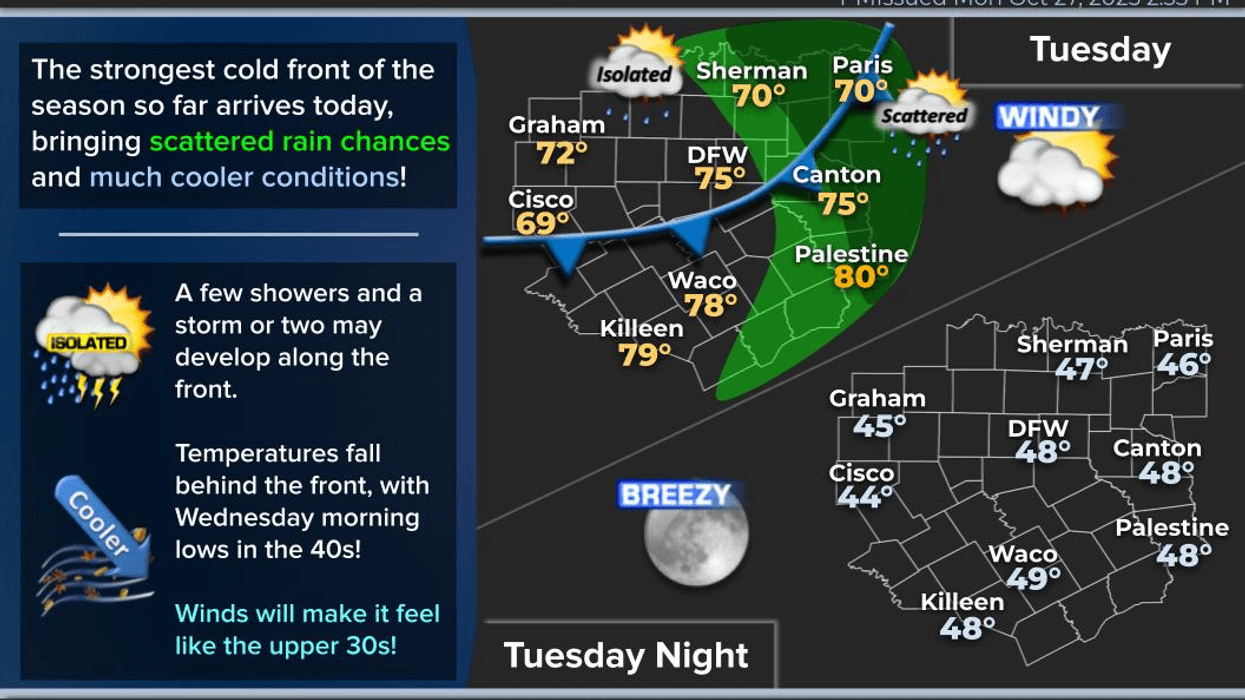
I'm tracking the strongest cold front of the fall season, which will arrive after noon, bringing strong winds, scattered showers, and sharply colder temperatures. I'm also monitoring Hurricane Melissa, expected to make landfall in Jamaica later this afternoon.
Welcome to Tuesday. We're experiencing a cloudy sky and mild temperatures, with readings mainly in the upper 60s. Nothing is currently on radar, but this will change this afternoon with scattered showers along a fast-moving cold front. The wind will shift to the Northwest, gusting up to 45 mph, and temperatures will drop from the mid-70s to the 50s by dinner time. A wind advisory will be in effect from noon today until 6:00 p.m. Wednesday.
Tomorrow morning will bring clear skies and windy conditions, with morning lows dipping into the mid to upper 40s. Wind chills will be in the upper 30s due to 30 plus mile per hour wind gusts. Sunny, windy, and cool conditions will prevail on Wednesday afternoon, with afternoon highs struggling to reach 60° and a north wind gusting up to 45 mph. Protect your plants and bring your pets indoors before bedtime on Wednesday, as morning lows will dip into the upper 30s to mid 40s, potentially leading to frost advisories north and northwest of DFW.
Thursday will be less windy with plenty of sunshine, and afternoon highs will reach the mid 60s. Still, temperatures will remain cool for this time of year. Morning lows will dip into the 40s on Friday, with afternoon highs in the upper 60s.
A nice and cool weekend is ahead, with afternoon highs in the mid to upper 60s on Saturday and low 70s on Sunday, as a weak front arrives early Saturday morning. Temperatures will warm up to the mid-70s on Monday under a mostly sunny sky.
As for Hurricane Melissa, as of 5:00 a.m. this morning, maximum sustained winds are at 175 mph, with higher gusts. It is expected to make landfall in western Jamaica later this afternoon. Melissa is the 8th strongest hurricane in the Atlantic basin, considering its wind speed. Jamaica can expect life-threatening storm surge, heavy rain, and wind over the next 12 to 18 hours. Melissa's track will continue to speed up, heading Northeast over the next 48 to 72 hours, impacting Eastern Cuba and the Central and Southeastern Bahamas. Some weakening is expected, but it will remain a strong hurricane.
Enjoy the cool down and please pray for Jamaica. Have a blessed day.
7-Day Headlines:
DFW hit 81 degrees on Sunday.
Wind Advisory Tues Noon - 6pm Wednesday.
Early afternoon cold front. Wind gusts to 40mph.
Mid afternoon showers possible.
Below average temperatures the rest of the week.
Frost possible Thursday morning.
Weak-dry weekend cold front.
*Yest Rain: 0.00"; Yest High: 81 Low: 61
*Today's Averages: High: 74; Low: 53
*Record high: 90 (1935); Record low: 30 (1925)
*October Rain: 0.24"; Surplus: 0.97"
*2025 Rain: 32.91"; Surplus: 1.86"
*Sunrise: 7:44am; Sunset: 6:39pm
Tuesday: *Wind Advisory* ** Afternoon cold front** Morning clouds, late afternoon sun. A few showers. High: Mid 70s, falling into the 50s by dinnertime. Wind: NNW 20-30, G40 mph.
Tuesday night: *Wind Advisory* Clear, windy and chilly. Low: Mid to upper 40s. Wind chills in the upper 30s. Wind: NNW 15-25, G35 mph.
Wednesday: *Wind Advisory* Sunny, VERY windy and cool. High: Near 60. Wind: NNW 20-30, G45 mph.
Thursday: Morning frost, afternoon sun. Not as windy. Cool! Low: 38-43; High: Mid 60s.
Friday: Sunny and perfect! High: Low 70s.
Saturday: Weak cold front. Passing high clouds and cool. High: Mid to upper 60s.
Sunday: Mostly sunny and awesome! High: Low 70s.
Monday: Sunny, continued nice. High: Mid 70s.
LISTEN on the Audacy App
Tell your Smart Speaker to "PLAY 1080 KRLD"
Sign Up to receive our KRLD Insider Newsletter for more news
Follow us on Facebook | Twitter | Instagram | YouTube