UPDATE 6:30 P.M.
The National Weather Service has placed Lancaster, Ennis, and Terrell under a severe thunderstorm warning until 7:30 p.m.
UPDATE 6:10 P.M.
The National Weather Service has placed Denton, Little Elm, and Corinth under a severe thunderstorm warning until 7 p.m.
The NWS has also reported Quarter size hail in Saginaw and Haslet.
UPDATE 5:50 P.M.
The National Weather Service has placed Waxahachie, Cleburne, and Corsicana under a severe thunderstorm warning until 6:30 p.m.
Elsewhere, Waco, Gatesville, and Hewitt are under a severe thunderstorm warning until 6:45 p.m.
UPDATE 5:30 P.M.
The National Weather Service has placed Fort Worth, Arlington, and Irving under a severe thunderstorm warning until 6:30 p.m.
UPDATE 4:50 P.M.
The National Weather Service has placed Gatesville, Oglesby, Evant, Dublin, Hamilton, Hico, Stephenville, Tolar, and Gordon under a severe thunderstorm warning until 5:15 p.m.
UPDATE 4:00 P.M.
The National Weather Service has placed Goldthwaite under a severe thunderstorm warning until 4:45 p.m.
UPDATE 3:35 P.M.
The National Weather Service has placed Comanche, Gustine, and Proctor under a severe thunderstorm warning until 4:30 p.m.
UPDATE 3:05 P.M.
Storms are breaking out well to the Southwest of DFW in the Severe Storm Watch area. At their current speed and continued enhancement in aerial coverage, the timeline looks to be between 6 p.m. and 9 p.m. from Granbury NE to Rockwall.
All forms of severe weather are possible. Large hail will be the main threat and an isolated tornado or two are not out of the question. A small percentage of you will be impacted by either one of these storm parameters.
A new storm or tornado watch will be issued in a few hours for the rest of North Texas.
UPDATE 2:30 P.M.
The National Weather Service has placed parts of North and Central Texas under a severe thunderstorm watch. This watch will remain in effect through 9 p.m.
We're waking up to temperatures very mild for this time of the year, with a lot of wind and cloud cover. Readings are in the low seventies! Feels more like the Texas coast outside right now.
Conditions are a little bit more favorable today than yesterday for scattered severe storms to break out by late afternoon, just west of the Dallas/Fort Worth area and move through the Metroplex between 5pm and 10pm. Only about half of you will see rain rain out of this system. This event will not be a line of storms like we've experienced over the past few events.
That being said, isolated supercells will break out along Hwy 281 (50 miles west of FTW) by mid to late afternoon. These individual cells will be capable of producing large hail and damaging wind. The tornado threat is low, but possible. If you want to leave work an hour two early today, it might not be a bad idea. Also, I think the kids will get out of school in plenty of time before the storms possibly hit your neighborhood. As usual, I will keep an eye on things and jump on KRLD if necessary. Good news...you can sleep well overnight tonight, as the storms will be east before bedtime. Afternoon highs will reach the mid eighties today with a lot of wind.
A cold front will move through the area by mid morning tomorrow and may produce a thin line of showers and storms. These storms may form right on top of us or just to our south and east. It's a close call. Either way this will be a wind threat along with some small hail. Cooler/drier air will filter in tomorrow with clearing skies by late morning. Afternoon highs will only be in the mid to upper seventies, with a north wind gusting to 30mph.
Thursday looks nice with lows in the upper forties to low fifties, daytime highs will reach the mid to upper seventies. Friday warms into the low to mid 80s.
This weekend, a cold front will be flirting with us, so temperatures may need to be tweaked down out of the 80s into the 70s and storm coverage will need to be watched as well. There could be some strong storms around, but again it's still 4 to 5 days away. I'll have plenty of time to analyze new data as it streams in.
Please stay weather aware late this afternoon through the evening hours.
*Yest Rain: 0.00"; *Yest High: 89; Low: 71
*Today's Averages: High: 76; Low: 54
*Record high: 95 (1972); Record low: 31 (1940, 1957)
* April rain: 1.33"; April surplus: + 0.36"
*2022 Rain: 5.56"; 2022 deficit: 4.10"
*Sunrise: 7:02 am; Sunset: 7:56pm
Today: Morning clouds, afternoon sun. Scattered severe storms (5pm-10pm). Wind, hail, isolated tornadoes. Windy and warm. High: Mid 80s. Wind: South 15-25, G35 mph.
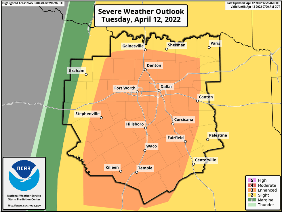 Scattered severe storms (5pm-10pm). Wind, hail, isolated tornadoes.National Weather Service
Tonight: Storms move out before midnight. Mostly cloudy, mild and windy. Low: Mid to upper 60s. Wind: South 15-25, G35 mph.
Tomorrow: Isolated morning storms. Greatest chance south and east of DFW. Cold front clears us out by afternoon. Breezy and cooler. High: Upper 70s. Wind: WNW 15-25, G30 mph.
Thursday: Sunny and nice. High: Mid to upper 70s.
Friday: Mostly sunny and warmer. High: Low to mid 80s.
Saturday: Partly cloudy, warm and windy. Slight chance for showers and storms late. High: Mid 80s.
Easter Sunday: Slight chance for showers and storms. High: Low 80s.
Monday: Partly cloudy, windy and cooler. Slight chance of showers and storms. High: Upper 60s.

LISTEN on the Audacy App
Sign Up and Follow NewsRadio 1080 KRLD