UPDATE: 10:27 PM - Wednesday 3/24
New tornado watch until 4:00 a.m. Cold front is moving through the area. It seems a little too cool for tornado development, but hail up to the size of quarters and heavy rain will be the threat after midnight to 6:00 a.m.
UPDATE: 4:50 PM - Wednesday 3/24
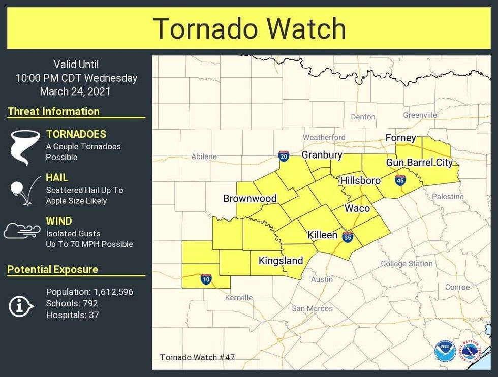
Tornado watch south of I-20 until 10:00 p.m.. This does not include Dallas and Fort Worth. Doesn't mean you need to stop being weather aware. An isolated tornado still not out of the question, along with some very large hail this evening. @KRLD is monitoring.
 NWS
NWS
UPDATE: 11:30 AM - Wednesday 3/24
Parts of north Texas have been bumped up to a level 3 out of 5 (Enhanced risk, orange) for large hail, damaging wind, and isolated tornadoes.
The greatest chance for hail bigger than quarters across DFW area will be between 6:00 p.m. and 10:00 p.m.
A slight tornado threat in orange shaded area, then we'll get a 2 to 3 hour break, then heavy rain, a lot of noise, and small hail will be the threats from around 1:00 a.m. to 7:00 a.m.
There may also be some flash flooding in some areas, especially just South and East of the Dallas Fort Worth area. Some areas may pick up 3 to 4" of rain before all is said and done.
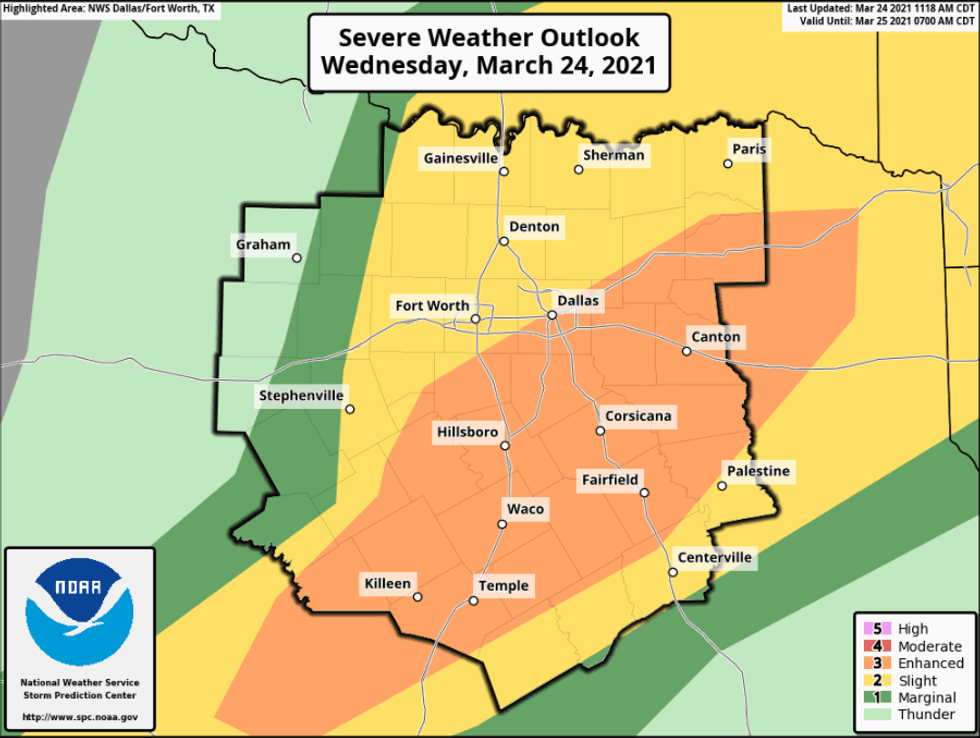 Severe Weather Outlook 3/24/21@NWSFortWorth
Tune to NewsRadio 1080am KRLD starting later this afternoon through the evening hours for updates as conditions warrant.
Severe weather season is upon us and we have another threat for hail wind and isolated tornadoes later this afternoon through Thursday morning. The greatest threat for severe weather will be from 4:00 p.m. to midnight. I'll be keeping one eye open as usual.
Before the bad weather moves in, you'll enjoy cool temperatures this morning and mild readings this afternoon... as clouds increase from southwest and northeast. Afternoon highs will reach the mid to upper 70s.
Our weather improves tomorrow through the weekend. You'll enjoy plenty of sunshine. Seasonable temperatures are expected tomorrow, with warmer temperatures on Friday and Saturday.
There's a very slight chance of a shower early Sunday morning as a cold front passes through the area, but most stay dry. Temperatures will be a bit cooler on Sunday.
By Monday, new data now suggests that a chilly rain may fall. Sunshine and warming temperatures will return on Tuesday.
IMPORTANT:
With severe weather approaching later today, now is a good time to go out and buy you a weather radio. This will come in handy in the middle of the night, or if you lose power or satellite television. Please make sure you know the different ways to receive warnings when they are issued. Also, when you hear outdoor warning sirens going off, make sure you're indoors and start to gathering information as fast as possible.
NOTE: The tornado threat is low this evening, but it's slightly higher then the last event due to warmer temperatures and time of day. I will jump on KRLD as conditions warrant later this afternoon through the evening.
Lastly, please download the radio.com app, search KRLD and click on the heart to favorite us. You can listen to us 24/7 any time, anywhere.
*Yest Rain: 0.00"; *Yest High: 74; Low: 48
*Today's Averages: High: 71; Low: 49
*Record high: 89 (1929, 2018); Record low: 30 (2006)
*March rain: 2.43"; March deficit: .019
*2021 Rain: 5.50"; 2021 deficit: 1.91
*Sunrise: 7:26am; Sunset: 7:43pm
Today: Sunny, breezy and mild. Increasing storm chances by late afternoon and evening. Isolated severe. Level 2 out of 5 (Wind, hail, isolated tornadoes). High: Mid to upper 70s. Wind: SE 10-20, G25 mph.
Tonight: Showers and storms a good bet, especially after midnight. Isolated severe (wind and hail). Low: 48-52. Wind: North 10-20 mph.
Tomorrow: Morning showers and isolated storms, then decreasing clouds. High: Upper 60s. Wind: NW 10-20, G25 mph.
Friday: Sunny, breezy and warmer. High: Mid 70s.
Saturday: Sunny and a bit warmer. High: Low 80s.
Sunday: Morning clouds, afternoon sun. Cooler. High: Mid to upper 60s.
Monday: Mostly cloudy. Chance of showers. Cool. High: Low 60s.
Tuesday: Mostly sunny and windy. High: Near 70.