A large area of high pressure in the upper levels of the atmosphere will continue to grip the Eastern two-thirds of the nation all this week and into the upcoming weekend.
We're waking up to temperatures near 80 degrees, with a south wind gusting to 25 mph. If there's any good news on the horizon, the heat advisories have been shifted east of the Dallas-Fort Worth area, temporarily, but temperatures will still be well above average for this time of the year over the next seven days.
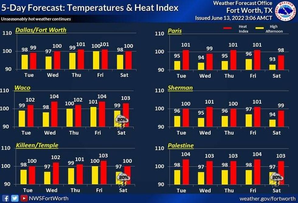
Daytime humidity levels will drop off just a little bit this week, but it's still going to be hot. The record high for today is 102 degrees and we'll come close to tying that record, but heat index values will be a little bit lower, but still brutal. It'll feel more like 107° today. More of the same for the rest of the week and into the weekend, with daytime highs near 100 degrees, heat index values will be close to 105 degrees through the period.
There will also be a little bit of some upper-level Saharan dust overhead, so that will filter out a little bit of the sunshine.
Please limit your outdoor activity during peak heating hours, especially those of you that suffer from respiratory problems. Other things you need to remember, make sure your pets have a cool place to stay and please check the backseat of your vehicles before leaving them. Check for kids and pets. Temperatures in your vehicle can exceed 130 degrees during peak heating hours in a short period of time.
A weak cold front may back into north Texas this weekend, giving us a very slight chance of a late day shower or storm, but chances are very very slim.
Stay cool and hydrated my friend and remember to enjoy the weather, when you can, it's the only weather you've got.
___________________________________________________
 NWS
NWS
7-Day Headlines:
* Yesterday's high at DFW: 102 degrees.
* No Heat Advisory today for DFW, but still hot.
* Heat Advisories just east of DFW.
* Near record high (102 degrees, 1912,1924) today.
* Saharan Dust.
* Near 100 all week long.
* Slight rain chance this weekend.
* Summer arrives in 8 days.
_________________________________________________________
*Yest Rain: 0.00"; *Yest High: 102; Low: 80
*Today's Averages: High: 91; Low: 72
*Record high: 102 (1912, 1924); Record low: 59 (1979)
_________________________________________________________
* June rain: 2.64"; June surplus: +1.07"
*2022 rain: 12.41"; 2022 deficit ">
*Sunrise: 6:19am; Sunset: 8:37pm
Today: Heat Advisory "EAST"of DFW...Partly cloudy, windy, hot and humid. Near record high (102 degrees). High: 100-103. Heat index 105+. Wind: South 15-25, G30 mph.
Tonight: Fair, breezy, warm and muggy. Low: Near 80. Wind: South 15-25 mph.
Tomorrow: Sunny, hot, breezy and humid. High: Near 100. Heat index ~105. Wind: South 15-25, G30 mph.
Wednesday - Friday. Sunny, breezy, and hot. Highs: 97-101. Heat index ~105 degrees.
Weekend: Mostly sunny and continued hot. Slight chance of a late day shower or storm. Highs: Upper 90s.

LISTEN on the Audacy App
Sign Up and Follow NewsRadio 1080 KRLD