


More precipitation is expected in North Texas, but it will conclude in time for the weekend. As a result, numerous lawn mowers will be in operation this weekend, as the sun reappears and temperatures remain slightly below average.
Good morning, and happy almost Friday. We are waking up to partly cloudy skies and pleasant temperatures for this time of year. Most areas are experiencing temperatures near 60 degrees. The radar is currently quiet, but showers will begin to develop to our southwest by mid-morning and move in our direction through the afternoon hours. The precipitation will be light, with most areas receiving less than a quarter of an inch. Slightly higher totals are expected south of Interstate 20. Temperatures will remain cool for this time of year, with highs struggling to reach the mid-60s. The north wind will continue at 10 to 20 mph.
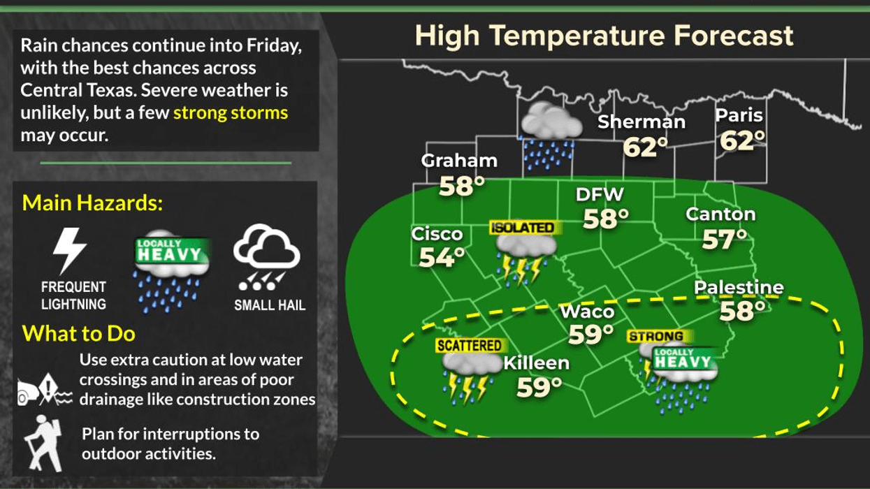
I am tracking our next storm system, which is currently moving through western Mexico. This system will move across central Texas tomorrow, bringing widespread moderate to heavy rain and thunderstorms to all of North Texas. The rain is expected to begin by the time you leave for work Friday morning. Please ensure you have an umbrella, and feel free to enjoy the rain if you wish. Rainfall totals will range from 1 to 2 inches across Dallas and Fort Worth, with totals exceeding 2 inches south of Interstate 20, where thunderstorms are possible.
I am concerned about potential flooding, particularly in areas that have experienced rain over the past few days. A flood watch may be issued for areas south of I-20. Time will tell. Temperatures will remain in the 50s throughout the day, with a north wind at 10 to 20 mph. It will be a cool and raw day, which is unusual for early May.
Fortunately, all the rain will have moved east of our area by Saturday morning, just in time for the weekend. Temperatures will be chilly, with readings in the mid to upper 40s. Plenty of sunshine is expected, with highs in the low to mid-70s on Saturday afternoon.
The pleasant weather will continue through Sunday and early next week, with a warming trend. Highs will reach the mid to upper 70s on Sunday, near 80 on Monday, and return to the mid to upper 80s by Tuesday and Wednesday. There is a possibility of additional showers entering the picture late Tuesday evening, but this is still uncertain. Please prepare for significant rain tomorrow. Enjoy the upcoming weekend and the weather when you can, it's the only weather you've got!
7-Day Headlines:
- DFW Airport hit 69 degrees on Wednesday.
- Scattered showers today
- Moderate rain all day Friday, heaviest south of I-20
- Threats: Lightning, areas of flooding
- Highs in the 50s on Friday
- Sunshine returns this weekend, highs in the 70s
- Warming next week
- Download our AUDACY app. Listen to KRLD at home!
Almanac:
- Yest Rain: 0.02”; Yest High: 69; Low: 60
- Today’s Averages: High: 79; Low: 59
- Record high: 95 (1928); Record low 35 (1903)
- April rain: 5.01”; Surplus: 1.92”
- 2026 Rain: 10.17”; Snow: 2.4” Deficit: <1.93”>
- Sunrise: 6:41am; Sunset: 8:10pm
Forecast:
Thursday: Cloudy and cool. Areas of showers after 10am. Nothing severe. High: Mid 60s. Wind: North 10-20 mph.
Thursday night: Cloudy, breezy and cool. Areas of showers. Low: Mid to upper 50s. Wind: ENE 10-15 mph.
Friday: Cloudy, breezy and chilly. Widespread rain with some thunder. Heaviest south of 1-20. Nothing severe. Flooding a concern by evening. 1.00” to 3.00” possible. Heaviest south of I-20. High: Falling through the 50s. Wind: North 15-25 mph.
Saturday: Morning clouds, afternoon sun. Comfortable! High: Low 70s.
Sunday: Clear and beautiful! High: Mid to upper 70s.
Monday: Partly cloudy and warmer. High: Near 80.
Tuesday and Wednesday: Partly cloudy, breezy and warm. High: 88-92.
LISTEN on the Audacy App
Tell your Smart Speaker to "PLAY 1080 KRLD"
Sign Up to receive our KRLD Insider Newsletter for more news
Follow us on Facebook | Twitter | Instagram | YouTube


