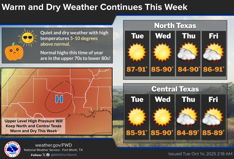

We have been experiencing a prolonged period of benign weather for nearly three weeks, with no rainfall recorded at DFW Airport. This trend is expected to persist for an additional seven days or longer. One certainty is that above-average temperatures and below-average precipitation will continue for the foreseeable future.
Good morning, ladies and gentlemen. I hope your Monday was exceptional. Mine was indeed. Thank you for inquiring. We are waking up to temperatures in the mid-60s to near 70°F once again under clear skies. There is no precipitation on the radar, and none is expected until possibly this Saturday. I will elaborate on this later. Today will be sunny and beautiful, with afternoon highs in the upper 80s.
The upper-level ridge of high pressure will maintain its grip on the area through the end of the week. Afternoon highs will approach 90°F, while morning lows will range from 65°F to 70°F. Expect more of the same.
A powerful storm system is currently entering California and will ride the ridge to the north of us through the week and into the northern plains states this weekend. It will drag a weak front through the area towards Saturday evening, leading to scattered showers and storms in Oklahoma. Some of these storms will build back into North Texas by Saturday evening. Currently, if I were to draw a line demarcating areas that will receive rainfall, it would extend from Sherman to McKinney to Waxahachie and points east, with the highest coverage and potential for strong storms in East Texas, Arkansas, and northern Louisiana into Sunday. Areas west of this line will not receive any precipitation.
Temperatures on Sunday will be slightly cooler, with afternoon highs in the low to mid 80s with ample sunshine. A north wind will blow at 5 to 15 mph. Winds will rapidly shift to the south on Monday, with highs returning to the upper 80s. These warm temperatures will persist at least through the middle to end of next week before our next system may impact the area towards the following weekend. This system may be slightly stronger. Stay tuned.
I would like to express my gratitude to everyone for listening to KRLD and following my Facebook page. Your support means the world to me! Enjoy the weather when you can y'all, it's the only weather you've got.
7-Day Headlines:
DFW hit 89 degrees on Monday.
Upper level high dominates all week.
No rain at DFW for the past 18 days.
A warm and dry week ahead.
Above average temperatures.
Cold front late Saturday, slight rain chance, cooler Sunday.
*Yest Rain: 0.00”; Yest High: 89 Low: 70
*Today’s Averages: High: 79; Low: 58
*Record high: 99 (1910); Record low: 40 (1977)
*October Rain: 0.00”; Deficit:
*2025 Rain: 28.16”; Deficit: 0.65”
*Sunrise: 7:33am; Sunset: 6:55pm
Tuesday: Mostly sunny and warm. High: Upper 80s. Wind: East 5-10 mph.
Tuesday night: Clear and pleasant. Low: 65-70. Wind: E 5-10 mph.
Wednesday: Sunny and warm. High: Upper 80s. Wind: E 5-10.
Thursday and Friday: Mostly sunny, continued warm. Highs: Upper 80s.
Saturday: Increasing clouds, continued warm. Slight chance of showers and storms by late evening. Weak cold front. High: Near 90.
Sunday: Sunny and slightly cooler. High: Low to mid 80s.
Monday: More of the same. Sunny and warm. High: Mid to upper 80s.
LISTEN on the Audacy App
Tell your Smart Speaker to "PLAY 1080 KRLD"
Sign Up to receive our KRLD Insider Newsletter for more news
Follow us on Facebook | Twitter | Instagram | YouTube