Do you enjoy roller coasters? Are severe weather conditions a source of fear for you? Do you prefer temperatures in the 40s and highs in the 60s? Over the next 7 to 10 days, North Texas can expect a diverse range of weather conditions. I will provide a detailed breakdown below.
As we return to our daily routines, I hope you had a pleasant weekend. Saturday was somewhat noisy, with only a quarter inch of rain recorded at DFW Airport, while other areas experienced more or less precipitation. Sunday, however, was exceptionally beautiful, with afternoon temperatures reaching 76 degrees, just one degree below average for this time of year. This marked the end of our 5-week streak of above-average temperatures.
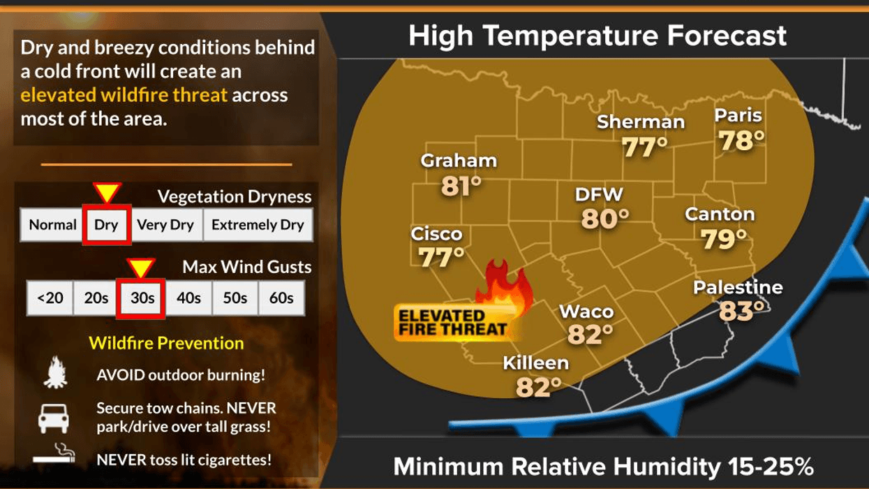
This morning, temperatures range from 47 to 61 degrees, depending on your location and wind conditions. Enjoy this brief period, as temperatures are expected to rise significantly today. South-southwest winds with gusts up to 40 mph will bring warm air from the high plateaus of West Texas into North Texas. It would not be surprising to see temperatures reach 90 degrees at DFW Airport today. Additionally, please be aware of the high grass fire danger in areas west of Fort Worth today. Wind may gust to 40mph this afternoon.
Before midnight tonight, our next cold front will arrive, bringing dry conditions. Temperatures will dip into the 50s for your Tuesday morning commute, with afternoon highs reaching the upper 70s, close to average for this time of year. North winds blowing at 10 to 20 mph will create another high grass fire danger day across North Texas. Please keep this in mind and extinguish any lit cigarettes in a half-filled bottle of water inside your vehicle.
Later this evening, around bedtime, our next cold front will move through the area, bringing no rain. You can expect temperatures between 53 and 58 degrees tomorrow morning, with north winds blowing at 10 to 20 mph, creating a chilly atmosphere.
Tuesday is expected to be sunny and beautiful, with afternoon highs reaching 78 degrees. The grass fire danger will once again be very high.
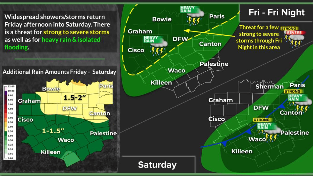
From Wednesday to Sunday, temperatures will range between 80 and 85 degrees, with the warmest temperatures expected over the weekend. During this period, a couple of upper-level disturbances will pass through the South Central Plains states. The first disturbance will bring a few scattered strong storms to our area on Thursday evening. A stronger system will drag the dry line through the area late Friday into early Saturday morning, which is the time frame I will be monitoring for potential severe weather across the area.
Please stay tuned to NewsRadio 1080 KRLD AM throughout the week for updates on timing, severity, and rainfall totals. No major cold fronts are expected to impact our area during this time frame. However, next week's forecast looks entirely different.
Thank you for your attention, and I hope you have a great day today. Enjoy the weather when you can folks, it's the only weather you've got!
7-Day Headlines:
* DFW Airport reached 76 on Sunday. 0.24" of rain on Saturday.
* VERY warm today. Grass fire danger west of Interstate 35W.
* DRY cold front tonight.
* High grass fire danger Tuesday. Cooler.
* Above average temperatures through the weekend.
* Strong storm threat late through early Saturday.
*Yest Rain: 0.00"; Yest High: 76 Low: 59
*Today's Averages: High: 77; Low: 56
*Record high: 95 (1934); Record low: 33 (1989)
*October Rain: 0.00"; Deficit:
*2025 Rain: 28.16"; Deficit:
*Sunrise: 7:37am; Sunset: 6:48pm
Monday: Mostly sunny, very windy and warm. Grass fire danger west of Fort Worth. High: Near 90. Wind: SSW 15-25, G40 mph.
Monday night: Clear and cooler. Late evening DRY cold front. Wind: NNE 10-20 mph.
Tuesday: Sunny breezy and pleasant. Grass fire danger across North Texas. High: Upper 70s. Wind: NNE 15-25 mph.
Wednesday: Mostly sunny and comfortable. High: Low 80s.
Thursday: Partly cloudy, breezy and pleasant. Isolated late day strong storms. High: Low 80s.
Friday: Partly cloudy and muggy. Scattered late day and evening strong storms. High: Low 80s.
Saturday: Early morning showers and storms, clearing breezy and mild. High: Low 80s.
Sunday: Mostly sunny and pleasant. High: Mid 80s. BIG changes next week.
LISTEN on the Audacy App
Tell your Smart Speaker to "PLAY 1080 KRLD"
Sign Up to receive our KRLD Insider Newsletter for more news
Follow us on Facebook | Twitter | Instagram | YouTube