As anticipated, the rain moving through North Texas during the early morning hours did not intensify into severe weather. Most areas received at least a half inch of rain, and this precipitation will continue to move out of North Texas throughout the morning hours.
Good morning, everyone. It is almost Friday again. Hopefully, your morning is progressing smoothly as you pour your first cup of coffee and read this forecast discussion. As mentioned earlier, the rain will exit the area over the next couple of hours, giving way to clearing skies from west to east. Temperatures are currently in the mid to upper 60s, and we expect to warm into the low to mid 80s today as south winds pick up and gust up to 30 miles per hour. No rain is forecasted for the remainder of the day.
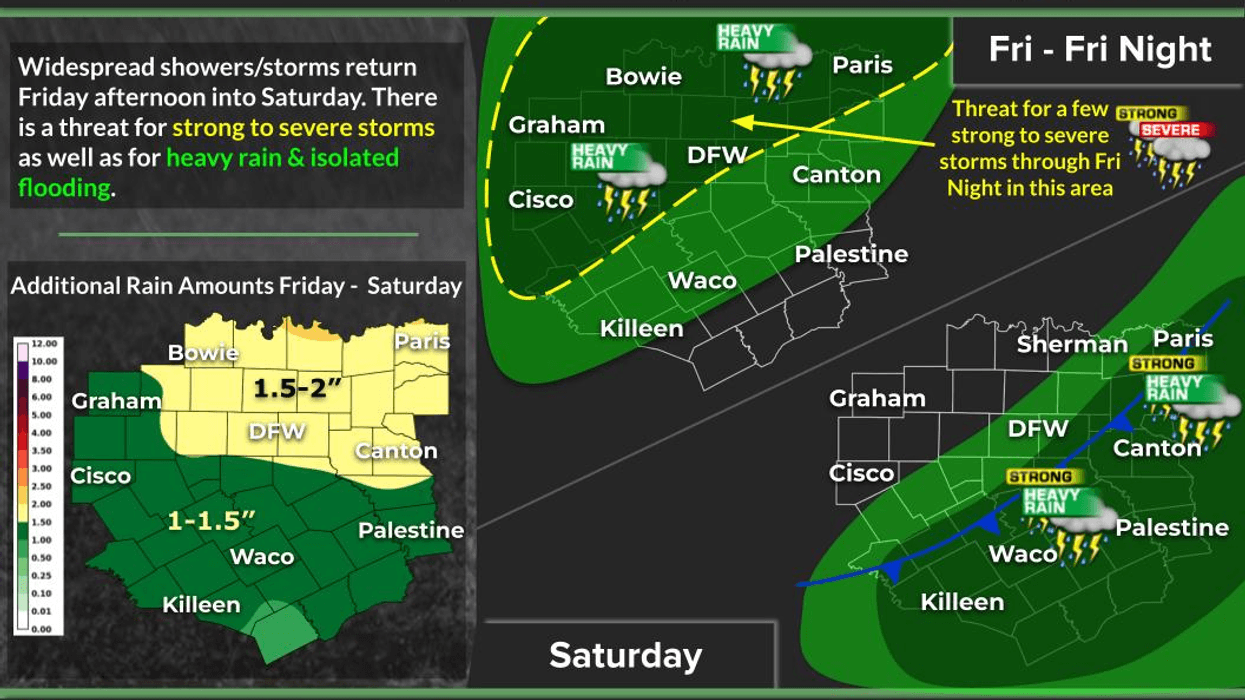
Clouds will increase overnight tonight as temperatures drop into the mid to upper 60s. It is advisable to have your umbrella handy on Friday, as showers and storms will develop to our southwest by early afternoon and spread across the area during the mid and late afternoon. There is a possibility of a few wind warnings and an isolated tornado threat to the west and northwest of the Dallas-Fort Worth area through late afternoon and early evening. This may impact your commute home from work and school on Friday. Afternoon highs may reach the low 80s, depending on cloud cover.
There will be a brief respite from the rain on Friday night, but by early Saturday morning, a cold front will rapidly approach from the northwest, bringing a large area of showers and storms. Isolated severe weather is possible toward the Red River early, followed by general heavy rain throughout most of Saturday morning. Some areas may receive an additional two to three inches of rain on top of what fell earlier this morning, leading to potential flooding concerns, especially near creeks, streams, and rivers.
The cold front is expected to arrive by mid-morning Saturday, with temperatures near 70°F, gradually falling through the 60s during the day. Rain should move south and east of us by afternoon, giving way to a cloudy, windy, and cool day.
On Easter Sunday morning, temperatures will be in the low 50s, with a north wind gusting up to 20 mph and considerable cloudiness overhead. If we are fortunate, we may see a glimpse or two of sunshine by late afternoon. Temperatures will remain on the cool side, with highs struggling to reach 65°F. Improving weather is expected Monday through Wednesday of next week, with highs in the mid to upper 70s and lows in the upper 40s to low 50s.
Have a great day today and enjoy the weather when you can, it's the only weather you've got.
7-Day Headlines:
- DFW Airport reached 87 on Thursday
- Rain moving out this morning, mid 80s today
- Scattered strong and severe storms return Friday afternoon
- Threats: Large hail, damaging wind, isolated tornadoes
- Strong storms produce heavy rain the first half of Saturday.
- Saturday morning cold front
- Cloudy and cool for Easter
Almanac:
- Yest Rain: 0.00”; Yest High: 87; Low: 69
- Today’s Averages: High: 74; Low: 52
- Record high: 94 (1918); Record low 32 (1936)
- March rain: 2.92”; Deficit: <0.48”>
- 2026 Rain: 5.16”; Snow: 2.4” Deficit: <3.53”>
- Sunrise: 7:13am; Sunset: 7:50pm
7-Day Forecast:
- Thursday: Morning showers, becoming partly cloudy and warm. High: low to mid 80s.Wind: South 15-25, G30 mph.
- Thursday night: Increasing clouds, windy and mild. Low: Mid to upper 60s. Wind: South 15-25, G30 mph.
- Friday: Morning clouds, some afternoon sun. Scattered storms by 3pm. Isolated severe, especially west and north of DFW. Threats: Hail, wind and isolated tornadoes. Windy and warm. High: Low 80s. Wind: South 10-20, G30 mph.
- Saturday: Morning cold front, showers and strong storms are a good bet. A few may be severe NE of DFW. Heavy rain moves SE of DFW after 1pm. Staying cloudy, becoming windy and cooler. High: 70 early, falling into the 60s.
- Easter Sunday: Mostly cloudy and cool. Low: Low 50s. High: Mid 60s.
- Monday: Partly cloudy and beautiful. High: Low 70s.
- Tuesday and Wednesday: Partly cloudy and pleasant. High: Mid 70s.